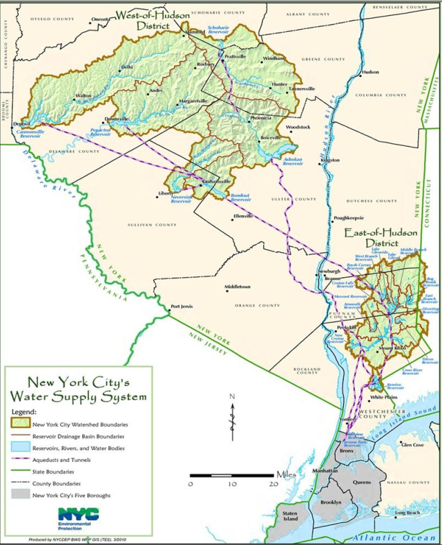
Cannonsville Dam is the westernmost dam in NYC's water supply, and it captures water from the Delaware River, which flows through Trenton, NJ and Philadelphia, PA. "Placed into service in 1964, Cannonsville Reservoir was the last of New York City’s 19 reservoirs to be built. Water diverted from Cannonsville Reservoir for drinking water enters the West Delaware Tunnel and travels 44 miles to the upper end of Rondout Reservoir. From there, it is carried in the 85-mile-long Delaware Aqueduct. Water is released downstream from Cannonsville Reservoir under the terms of the 1954 U.S. Supreme Court Decree, and a flow program, known as the Flexible Flow Management Program, agreed upon by New York City and the states of Delaware, New Jersey, New York and Pennsylvania. All other reservoirs in the city’s Delaware System have continued to meet their downstream release requirements under the Flexible Flow Management Program while the condition at Cannonsville is repaired." [Aug 2] It holds an eighth of the system's water supply. [NYtimes]
 |
| Cannonsville Public Meeting, page 3 |
 |
| New York City Department of Environmental Protection |
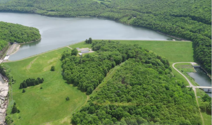
(When this photo was taken, I wonder if the river release was kept low to deliberately fill the reservoir to test the spillway or if there was a spring season wet enough to cause the overflow.)
 |
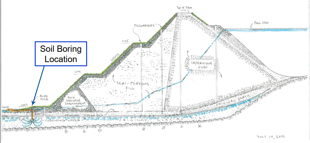
| Cannonsville Public Meeting, page 4 |
 |
| Cannonsville Public Meeting, page 5 |
 |
| Cannonsville Public Meeting, page 8 |
 |
| Cannonsville Public Meeting, page 10 |
They have also released the inundation map to the public even though it is marked "FOR OFFICIAL USE ONLY - NOT FOR DISTRIBUTION." This map indicates the impact of the worse case scenario of a breech with a full reservoir. It is not surprising that the whole town of Deposit would be under water. It is surprising that several blocks and bridges in Philadelphia would also be under water.
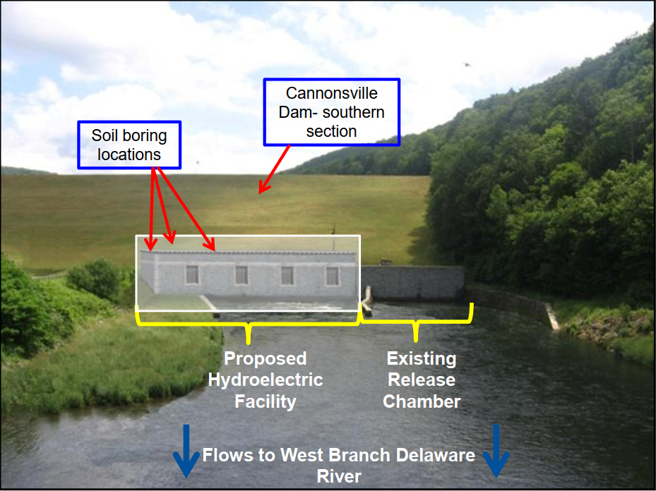
The photo below shows the water turbulence in the release chamber caused by the maximum release flow and the turbid water to the left caused by the aquifer puncture by the boring hole. You can see a relief-well drilling rig on the upstream side of the road at the base of the dam.
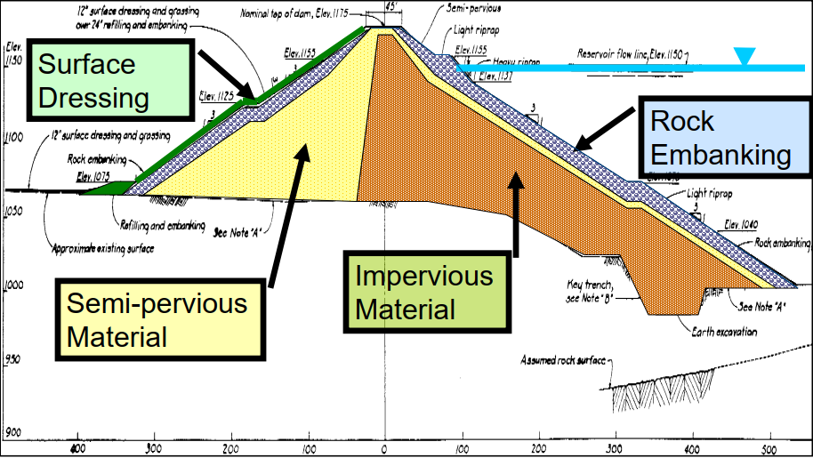
The repair has two stages. The first is to drill relief wells upstream with proper screens and casings so that clean water will flow through the rock embankment. These clean holes will relieve the pressure on the dirty holes and stop the release of sediment into the river. The second stage is to grout the soil sample holes and then drill grout holes around the dirty holes to create a grout curtain with pressurized grout. [July 23]
 |
| nyc.gov Flickr |
 |
| nyc.gov Flickr One of the two rigs drilling the relief wells. |
Four relief wells were enough to stop the turbid flow, and outflow rates started to shift to normal rates on July 29. In this case, normal was zero for drinking water because they switched to other reservoirs for drinking water to reduce the rate this reservoir was being drained. The river flow was reduced from 1500cfs to 500cfs between Aug 2 and Aug 5 per the advice of fisheries biologists. Inflow was 300cfs. At the time of the July 23 presentation, the water level was 1141.97' with 47.2 billion gallons of warm water and 37.5 BG of cold water. As of Aug 2, 25 BG of cold water remained. (I never found information on how much warm water was left. Nor if the water intake has inlets at different levels to control the temperature of the water that is released.) [Aug 2]
The second stage of repairs was finished Aug 21. Now they will gradually close the relief wells and verify that the dam's instrumentation shows values returning to levels comparable to what they were before the test bore holes were drilled. [Aug 26]
After two weeks of monitoring the instrumentation and the flow in the river, the repairs have been declared successful. The reservoir is expected to fill to normal capacity by late Spring, 2019. [Sep 17]
 |
| nyc.gov Flickr "This photo shows the cloudy discharge downstream of the dam just a few days after it was discovered." [It also shows the turbulence in the release chamber with a high release rate. In hindsight, the dam was not in danger and they did not need to release the water. But it makes sense that when there is a sign of trouble that they would drain first and think second. Nonetheless, it did take a week before they decided to start draining the reservoir even though it was close to capacity because of a wet June. [NYtimes]] |
 |
| nyc.gov Flickr "This photo shows the cloudy discharge after one relief well was installed and pumping. The discharge was reduced, but some remained along the grass and the stone abutment near the middle of the photo." |
 |
| nyc.gov Flickr "This photo shows the same area downstream of the dam on Aug. 7, after the cloudy discharge was successfully halted by the relief wells. Notice the water is so clear that rocks on the river bottom can be seen easily." |
No comments:
Post a Comment