(
Satellite)
This article has a lot of construction photos.
 |
usbr
"At the time of its completion, the dam was the fourth largest concrete dam and the fourth highest concrete dam in the United States." |
Bureau of Reclamation
posted two photos with the comment:
We’re taking it back to the 1950s! The first photo shows Hungry Horse Dam and Powerplant shortly after construction. The second captures the same view today—surrounded by lush Montana wilderness and still standing tall.
Located in northwestern Montana, Hungry Horse Dam helps generate clean hydropower, manage floods, and deliver water to communities throughout the Columbia River Basin.
📍 Completed in 1953
📏 564 feet tall
⚡ Powering the West, then and now.
.jpg) |
| 1 |
.jpg) |
| 2 |
Montana Historical Society
posted two photos with the comment:
The construction folks and the Bureau of Reclamation were pretty proud when they poured the 2,000,000th yard of concrete into Hungry Horse Dam southeast of Columbia Falls in northwestern Montana.
But it took 3,086,200 cubic yards of concrete to complete the 564-foot-tall dam, which "has a variable-thickness concrete arch structure with a crest length of 2,115 ft," according to the BOR. "The spillway is the highest morning-glory structure in the world. Water cascading over the spillway rim drops a maximum distance of 490 feet. The capacity of the spillway is 50,000 cubic feet per second, and the reservoir has a total capacity of 3,468,000 acre-feet."
It was built between 1948-1953 on the south fork of the Flathead River.
First photo courtesy of Imagine IF Libraries in Flathead County. The second is courtesy of the BOR.
Nick Sheedy: She backs up one cubic mile of water.
 |
| 1 |
 |
2
[Does the morning-glory spillway empty out of the square chute that is this side of the valve house? If so, why don't I see some water coming out? We can see water going into the spillway at the left side of the photo.] |
 |
| NBC, Jun 15, 2022 |
 |
| NBC, the implication is that this is the impact downstream with an output of 20 kcfs. |
 |
Photo via usbr-history
"View of Hungry Horse Dam "glory hole" spillway, passing 30,000 cubic feet of water per second -- [total capacity?] about 225,000 gallons per second. August 7, 1953." |
 |
Photo via usbr-history
"Telephoto view from point downstream on north side of canyon showing Hungry Horse power plant area. At left are the three 96' river outlet tubes, in center foreground is site of valve house. October 11, 1950." |
Bureau of Reclamation posted three photos with the comment: "In February 1950, Clyde Spencer, chief construction engineer of the Hungry Horse Project in northwest Montana, made a pivotal change to the design of the power plant. Originally planned to be constructed entirely of reinforced concrete, Spencer switched the plant’s structure to steel. This decision allowed work to continue during cold weather when pouring concrete was not possible. Upon its completion in 1952, the plant stood as the tallest building in western Montana at 150 feet [45.7m]."
 |
| 1 |
 |
| 2 |
 |
| 3 |
 |
Photo via usbr-history
"View showing the first of three ring follower gates being installed at Hungry Horse Dam to control flow of water through the 96" outlet tubes. October 2, 1950." |
I don't understand some of the facts in this list. For example, I don't see any gates on the morning glory spillway. And does the "transmission" figure mean that they can deliver only 3/4 of their capacity to the grid so that they can never run at 428mw?
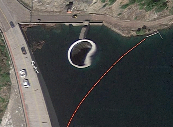
When I read about a morning glory spillway, I looked for it. I was surprised that it was so distorted. It should be a perfect circle. I fired up Google Earth to find a good image. I could not. Every image was distorted, although not as bad as this one. The distortion changed from image to image. I've looked at a lot of satellite images over the years and have never noticed distortion that was this bad for a stationary object.

.jpg)
.jpg)


.jpg)


No comments:
Post a Comment