Tuesday, September 8, 2015

CM&G: Illinois, Iowa & Minnesota Railway and Chicago, Milwaukee & Gary Overview

(Update: AJ Grigg blog)

Meghan Bannon Langan posted, cropped
Thank you for adding me to the group! This is the photo that brought me here. It was given to me with a box of my 2nd great grandfather's photos (Henry Elmer Watkins). He worked for the EJ&E. I'd love if he was the man in the white shirt in front, but I dont know for sure. I've become fascinated by the Gary line and look forward to looking through your posts and pictures.
Brian Keith Landis Picture is taken in Rockford ,Illinois
[The comments provide more photos about the railroad.]

Wayne DeMunn posted
This is an overlay of the Gary Line over the modern map of north-eastern Illinois showing the major highways of today. Other railroads are shown in a lighter shade of black. Thanks to Gene Shields for sending this one in.
Illinois, Iowa and Minnesota Railway was created in 1904. It was renamed Chicago, Milwaukee & Gary Railway (CM&G) in 1908. It was leased by the Milwaukee Road in 1922 and purchased by Milwaukee in May, 1930. (Abandoned Rails)  The railroad had two segments Rockford-Aurora and Joliet-Momence with trackage rights on the EJ&E to run between Aurora and Joliet.

One motivation for this post is that there has been quite a bit of activity on Facebook lately concerning "The Gary Line." Another motivation is that the Milwaukee Road used it to access its route to coal fields, the Chicago, Terre Haute & Southeastern.

Richard Mead commented on a post

The CM&G has its own Facebook group --- The Gary Line Remembered. It is easy to follow the route south of Joliet because it was converted to the Wauponsee Glacial Trail. A discussion concerning a photo of the Joliet depot determined that the yard is north of this trail terminus where Joliet Auto Parts is now located. If you access the link in the caption of the map, you will see there is some controversy as to where the northern part of the CG&M was located. (Update: I mapped how the EJ&E+CG&M got to Aurora when I researched an EJ&E Bridge in Aurora.)

The two pictures of the Peotone Trestle have now been moved to their own posting.

Pictures of the junction tower in, and an aerial photo of, Manhattan, IL where the CM&G crossed the Wabash Railroad.

Paul Grueger added some photos concerning the equipment.

Update: Pictures of Gary Line "footprint" in Rockford, IL      Wilton Center and Andres, Illinois, 8-28-77

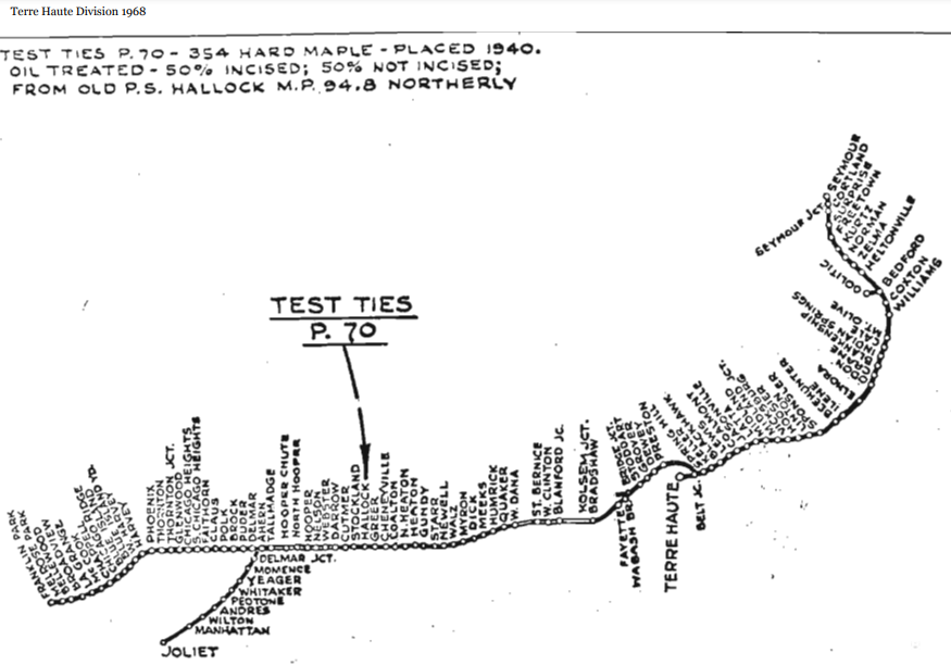
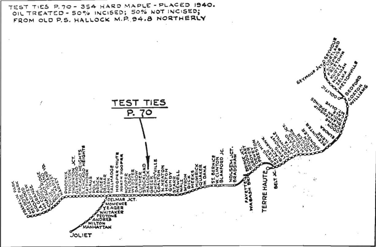
A 1968 track profile (pp6-13) of the CTH&SE includes details of the southern CM&G segment that was retained to help connect the Indiana segment with its mainline.
In the 1944 map below, Milwaukee had already abandoned the connection between Rockford and Kirkland because they had other routes in this area.
Bill Molony posted
This 1944 company issued map shows all of the Milwaukee Road's track and trackage rights in Illinois and Indiana at that time.


Paul Krueger posted
Here is a map of the proposed CM&G route to Gary, as of about 1908. This was shortly before they built to Delmar.
[This explains the "Gary" in the CM&G name.]

Since Wayne DeMunn posted in a public group, please follow the link because the comments contain a lot of historic pictures of DeKalb, IL including CM&G buildings.

Michael Maitland posted two images with the comment: "Interesting to see how railroads built belts around Chicago to expedite traffic.  Not sure of the purpose or success of the Milwaukee to do this.  Have traced out the line and found ROW still in existence.  What kind of traffic did this line see?"
Paul Krueger: The CM&StP gained control of the CM&G early in 1922 and acquired full ownership in 1930. They bought the line to improve access between the coal fields located on the CTH&SE which it acquired at the same time and became the Terre Haute Division. For a few years, there was an interdivisional train run between West Clinton on the Terre Haute Division and Savanna on the D&I Division that primarily hauled coal west and empties east. They used trackage rights between Aurora and Joliet on the EJ&E. The MILW abandoned the line between DeKalb and Aurora in 1947, along with the EJ&E trackage rights. Kirkland-Rockford was formally abandoned in 1930. Momence to Joliet was abandoned in 1978. I don't have the DeKalb branch abandonment date handy, but it was about the same time. There's pretty much nothing left of the CM&G except some industrial track in Rockford, Manhattan, and maybe Momence. Parts of it have become trails.
1

2

I normally don't include rolling stock, but this railroad is so rare that I could not pass this up.
Bill Molony posted
Jimmy Fiedler It's a old boxcar
Bill Molony This photo is of two newly delivered Chicago, Milwaukee & Gary cabooses, circa 1910. At that time, the CM&G carried passengers and express package service on their freight trains, and these cars were designed to accommodate those services.
Bill Molony The Chicago, Milwaukee, St. Paul & Pacific Railway (the Milwaukee Road) began operating the CM&G in 1922 under a lease agreement, and acquired ownership of it in 1930. The former CM&G line between Joliet and Delmar Junction was abandoned in 1978.

Note that this map was the proposal, not what actually got built.
Newspapers [Janesville Daily Gazette, 29 Sep 1905, Page 1] (source)
Jeff Kehoe Interesting, especially that planned route between Aurora and Joliet that does NOT appear to use EJ&E trackage rights.
Paul Krueger They always planned to build their own route between Aurora and Joliet.
Bill Molony posted
This is the listing for the Chicago, Milwaukee & Gary Railway Company from the June, 1922 edition of the Official Guide of the Railways.
The Illinois, Iowa & Minnesota Railway Company was built in 1904 and 1905 from Rockford in Winnebago County to Aurora in Kane County and from Joliet to Delmar in Kankakee County.
The II&M, by a contract dated February 21, 1905, secured overhead trackage rights between Aurora and Joliet over the Elgin, Joliet & Eastern Railway.
In June 1908, the II&M changed its name to the Chicago, Milwaukee & Gary Railway Company.
In January, 1922, the Chicago, Milwaukee, St. Paul & Pacific Railway Company began operating the CM&G, and on April 1, 1930, acquired ownership of the CM&G.
The former CM&G line between Joliet and Delmar was completely abandoned by 1980..
From the archives of the Blackhawk Railway Historical Society.

BRHS posted a different shade of this timetable
The Chicago, Milwaukee & Gary Railway Company's page, from the June, 1922 edition of the Official Guide to the Railways.
The CM&G had come under the control of the Chicago, Milwaukee & St. Paul Railway Company earlier that same year..
Note that the CM&G was still operating mixed (freight and passenger) trains at that time.

Richard Fiedler posted
1911 I believe. It came from a partial Official Guide I picked up today.
Jeff Kehoe: What that map was is "wishful thinking."
  
Track Profile

Some of Peter Zimmermann's comments on his posting document the abandonment:
The portion from Kirkland Junction to Rockford that was abandoned in 1930 is not easy to find, Kirkland to De Kalb [the last segment to go] in 1980 much easier than it. Aurora to De Kalb, part of that is a trail too. Joliet to Delmar Junction not too hard to see in spots of course.
A Flickr album of 56 photos (source)

Monday, September 7, 2015

Distributed Power Unit (DPU)

Many BNSF freight trains that I have watched had locomotives at the rear as well as at the front. Some trains even have locomotives in the middle. A remotely controlled locomotive is called a Distributed Power Unit or DPU. DPUs allow pulling longer trains with more horsepower without putting too much stress on the car couplers.

Someone asked on Facebook how a DPU (Distributed Power Unit) works. Some of the comments were particularly informative:

Jason Smith Here's what EMD says about distributed power:
Theory of Operation
Integrated Distributed Power (IDP) allows locomotives to be distributed throughout the train, which allows more locomotives to pull longer trains without separation from overpowering. ID
P allows locomotives not connected directly in consist to be controlled by the lead-controlling unit.
IDP enables the control of remote locomotive consists via radio messages, which emulate the normal 27 pin trainline connection between the locomotives.
The operator can control the remote consists in two modes: synchronous and independent. While operating in synchronous mode, the remote consists mimic the lead consist for throttle or dynamic brake requests. While operating in independent mode, the remote consists are controlled separately from the lead consist for better control over varying track profiles.
EMD LSI Integrated Distributed Power system is designed to provide synchronous and independent control to up to six locomotive consists located at points along the train, used in addition to the lead locomotive.
The system enables control of the remote units through command signals transmitted over a radio link from the lead unit. Operation of the system is such that several trains equipped with Integrated Distributed Power (IDP) can operate at the same frequency and within radio range of each other.
Advantages of Integrated Distributed Power
• Initial charging time of the train’s air brake system is significantly reduced;
• Brake applications and releases are quicker than in conventional consists, resulting in a shorter stopping distance (up to 30% faster);
• Power efficiency and overall tonnage capabilities are enhanced through synchronous and independent control of the motive power at multiple locations;
• More rapid acceleration and deceleration of the train is possible;
• IDP provides improved control of slack action, which reduces damage to cars, couplings and lading;
• IDP enables long trains to achieve and maintain higher speeds for faster, smoother runs and improved scheduling


Jason Smith Here's an old notice from work showing how BNSF determines dp usage on trains in certain subdivisions: February 18, 2010 ALL OPERATIONS MANAGEMENT MGMT. INSTRUCTION No. 130 TO ALL CONCERNED, SUBJECT: DP Power and Placement Requirements - Manifest Trains Below are Distributed Power locomotive requirements and placement guidelines based on total train tonnage and grades. Minimum DP remote power requirements applicable to DP manifest trains operating on the: Lampasas, Phoenix, Seligman, Thayer North, and Wichita Falls subdivisions Trailing Tonnage | Minimum DP Power Requirement and Placement 8,450 - 11,000 tons | 1 DP remote locomotive (8 RPA) on rear or cut in. 11,001 - 13,000 tons | 2 DP remote locomotives (16 RPA total) either as a single DP remote consist of 16 RPA or as two separate DP remote consists with one locomotive (8 RPA) each. 13,001 - 15,000 tons | 3 DP remote locomotives (24 RPA total) either cut in as a single DP remote consist or separated as two DP remote consists. Minimum DP remote power requirements applicable to DP manifest trains operating on the: Birmingham, Ft Worth, Ft Scott, Galveston and Thayer South Subdivisions Trailing Tonnage | Minimum DP Power Requirement and Placement 10,000 - 15,000 tons | 1 DP remote locomotive (8 RPA) on rear of cut in. 15,001 - 17,000 tons | 2 DP remote locomotives (16 RPA total) either as a single DP remote consist of 16 RPA or as two separate DP remote consists with one locomotive (8 RPA) each. 17,001 - 19,000 tons | 3 DP remote locomotives (24 RPA total) either cut in as a single DP remote consist or separated as two DP remote consists.

Jason Smith RPA in the above means rated power axle. For example, a GP30 has 4 RPA while an ES44C4 has 8 RPA.


Sunday, September 6, 2015

CTH&SE: Milwaukee's Chicago, Terre Haute & Southeastern Railway Overview

(This is a complete rewrite to take advantage of the map below.)

(Trainwatcher's Guide spelled this "Chicago, Terre Haute & South Eastern" with an abbreviation of CT&SE.)

Terre Haute Division Track Profile via Track Profiles

The Chicago, Terre Haute & Southeastern (CTH&SE) is the route in this map that goes south from Chicago Heights. It gained access to the Chicago market by connecting to the B&OCT in Faithhorn, IL and using trackage rights to North Harvey Junction. They also secured trackage rights on the IHB from North Harvey to Franklin Park. The purpose of the railroad was to bring coal from Southern Indiana to the Chicago area. Since it was built relatively late as far as railroad building was concerned, it skipped major towns so that it did not have to clutter up its tracks with passenger trains, prolonged reduced speed limits, and local freights.

Milwaukee's coal supply from its branch to Cherry and Oglesby was not enough to meet its needs during WWI. So in 1921 it leased the entire 298-mile CTH&SE for 999 years. (It bought it in 1948. [AbandonedRails])

In 1930 it acquired the CM&G/II&M that ran between Rockford and Delmar and connected with its mainline in Kirkland. Note only did this allow them to cancel their trackage rights on B&OCT and IHB, I'm sure this route was much less congested.


Bill Molony posted, cropped
1944
Bill posted again
Stuart B. Slaymaker Odd that Faithhorn wasn't shown. BIG frame Milwaukee Road depot, roundhouse, turntable, train order station. Fair sized yard. In the 1944 employees timetable, it had every letter in the alphabet, next the the name. Wish I still had that ETT!!!
Stuart Pearson THANKS FOR SHARING BILL! I once saw a Milwaukee Road 2-8-2 Mikado taking on Coal just South of the Washington St. Crossing of "The J" in Joliet. I was in a Car, and without my Camera so NO PIX~~DARNIT!

Bill Molony posted a 1920 Map
The Chicago, Terre Haute & Southeastern Railway Company of Illinois was Incorporated on November 30, 1910. The principal purpose of the CTH&SE was to bring southern Indiana coal to the Chicago area.
The CTH&SE was leased on June 15, 1921 to the Chicago, Milwaukee, St. Paul & Pacific Railroad for 999 years. The lease, however, lasted for only 27 years; The Milwaukee Road completely absorbed the CTH&SE in 1948.
The Milwaukee's former CTH&SE line between Chicago Heights and Terre Haute was abandoned in 1979. 
This original CTH&SE map is dated 1920.

Bill Molony posted
This map of the Chicago, Terre Haute & Southeastern Railway is dated 1920.
The Chicago, Terre Haute & Southeastern Railway Company of Illinois was chartered on November 30th, 1910 and was conveyed to the Chicago, Terre Haute & Southeastern Railway Company on December 22nd, 1910.
It was leased June 15th, 1921 (effective July 1st, 1921) for 999 years to the Chicago, Milwaukee & St. Paul Railroad (the Milwaukee Road).
The Milwaukee Road purchased and absorbed the road in 1948.
From the Blackhawk collection.
Alan Buck: Westport IN was the easternmost point of any western US railroad. Good piece of trivia!
Tony Creamer: Alan Buck It even beat out Pensacola, FL on the BN, which is kind of wild.
Bill Edrington: Alan Buck - Any idea whether Westport was the end of the line intentionally, or whether they just got that far and the money ran out? Other than making a connection with the Big Four, I never could understand...why Westport?
Tony Creamer: Bill Edrington I think the original idea was to make money bringing southern Indiana and southern Illinois coal into Chicago, and then someone thought maybe they could make more money hauling that coal to Cincinnati as well. They were always struggling, so yeah, they probably ran out of money--again. MILW buying them was an 11th hour save that was a pleasant surprise to their creditors, who all expected to lose everything they had invested in the CTH&SE.
Grayson Warbritton: Bill Edrington per Ghost Railroads of Indiana the line was originally the Evansville and Richmond to build a route between Elnora and Richmond IN. The E&R was sold to John Walsh who incorporated the Southern Indiana Railroad but was never continued as the Southern Indiana completed their route to Terre Haute. Eventually the Southern Indiana became a part of the Chicago, Terre Haute, & Southeastern which was eventually made part of the Milwaukee Road. The Westport branch would thus languish as a planned through route but died as a stubbed branch of a plan never fulfilled.
Bill Edrington: Grayson Warbritton - Thank you! John Walsh was also the guiding force behind the Illinois Southern Railroad, which eventually became part of the Missouri-Illinois. He planned to build an extension of that line from Salem, IL to Terre Haute, and that never saw the light of day either. Evansville to Richmond is interesting, as it would have tied into the Panhandle (PRR) at Richmond, and the PRR never did serve Evansville.

Bill posted again.
Scott A. Robinson I like the annotation of COAL FIELDS...they knew what the cash cow was.
Kevan Davis they paid too much for it.
Richard Fiedler Just a coal conveyor bypassed most every town of importance.
Robert Payne Following the track North of the coal fields on the Illinois side on Google maps, Many, if not all, of the towns along the line are completely gone. My great grandfather was a dispatcher for the Illinois Central in Rossville, IL, North of Danville, IL. I tried to find the towns KNOWLES and JOHANNOTT, No signs of them on Google Maps, but the track is still there and is being used. Thanks for sharing.
Bill Molony Those designated locations along the CTH&SE in Illinois were not actual towns or municipalities; most of them were just grain elevators or other railroad clients.

Christian Goepel posted with lower resolution but better exposure

BRHS posted
The Chicago, Terre Haute & South Eastern Railway Company was completed in 1907 as a means of reaching the coalfields of southern Indiana.
On July 1st, 1923, the Chicago, Milwaukee, St. Paul & Pacific Railway Company (the Milwaukee Road) leased the entire lines of the CTH&SE Railway Company, about 298 miles between Chicago Heights, Illinois and Westport, Indiana, and on the same date secured trackage rights from the Indiana Harbor Belt Railroad from Franklin Park to north Harvey;
It also uses trackage rights over the Baltimore & Ohio Chicago Terminal Railroad from North Harvey to a point south of Chicago heights under an agreement on August 1st, 1913.
The Milwaukee Road completely absorbed the CTH&SE Railway Company.in 1948.

Alan Follett The CTH&SE was probably the only line-haul railroad serving Chicago that never operated passenger service into the city. They did run a limited amount of local passenger service at the south end of the line, out of Terre Haute, which lasted well into the Milwaukee Road era. And I know of at least one occasion in the 1960's on which a C&EI Hummingbird detoured over the line.
Mark Fuller Alan Follett if no passenger service, what do the white dots and circles represent along the route in red? Local freight pickup?
Alan Follett Yes, I'm sure CTH&SE had freight service, and probably physical stations, at these points.

Bill Edrington Three of the so-called “granger” roads bought and/or built lines that connected their systems to the coalfields of the Illinois Basin, which includes the southern Indiana mines. In addition to the Milwaukee’s acquisition of the CTH&SE, there was CNW’s Southern Illinois Division, which ran from Nelson, IL via Peoria and South Pekin to CNW’s own mines around Benld, IL (and eventually linked up with the Litchfield & Madison to reach St. Louis); as well as the CB&Q’s Beardstown Division, which served a number of mines south of Centralia and fed coal to the Q system as well as to its parents GN and NP.
Dennis DeBruler The C&NW branch that still goes from DeKalb to Troy Grove used to go all the way to some coal mines on the east side of Spring Valley.
John Iwanski Milwaukee Road’s (and later the Soo Line’s) Latta subdivision. http://sooline.railfan.net/photos/santucci/latta2.html

Bill posted the map again
Jeff Toppen: Is the Chicago and eastern Illinois the same tracks?
Bill Molony: No. The Chicago, Danville & Vincennes Railroad was completed in 1870 and provided direct service between Chicago, Danville, Evansville and St. Louis. In 1881, the Chicago, Danville & Vincennes was consolidated with two other railroads to form the Chicago and Eastern Illinois. The Chicago, Terre Haute & Southeastern was built in 1917, east of and parallel to the C&EI.
Alan Follett: On at least one occasion in the Sixties, the northbound C&El Humming Bird (probably by then combined with the Georgian) detoured over this line. Some railfan friends returning from New Orleans scored unexpected rare mileage that day.
Jim Gordillo: All tracks in the southern end have been pulled east of Crane Naval Base, which is still served by INRD as far as I know. The 13 mile stretch from Bedford to Williams is a rail trail.

Richard Koenig posted:
Hello knowledgeable group: does anyone know if trains on the Southeastern were called north-south or east-west? Considering the general thrust of the CMStP&P, I would not be surprised if it's the latter, despite it feeling off-base within the state of Indiana.
North and south
Extra 201 and extra 204

This map shows both access routes abandoned because Milwaukee switched to using trackage rights on the NYC's Kankakee Belt between Danville, IL and Northwest Indiana in 1979. [AbandonedRails] You will sometimes see reference to Milwaukee using the Egyptian Line north of Danville. The Egyptian Line is a superset of the Kankakee Belt and includes the Big Four route that went from Danville to Cairo, IL. So both terms are reasonable for the segment north of Danville.

Bill Molony posted
This map shows the route of the abandoned MILW-CTH&SE route, with stops at Faithorn, Claus and Judy in Will County and Polk, Brock, Puder, Wilkstrom, Delmar Junction and Ahern in Kankakee County.
None of these places were municipalities; they were just the names that the railroad gave to those locations.


Some history of the route before Milwaukee bought it. The November, 1910, incorporation of CTH&SE took over the properties of the Southern Indiana and the Chicago Southern, which were in the hands of receivers and sold to the new company under foreclosure. 90% of the freight on this line was coal. [AbandonedRails] In OldMilwaukeeRoad (search for Terre) we learn that the Milwaukee Road had trouble getting coal from distant mines during World War I. That is why President Byram leased the CTH&SE --- to ensure reliable access to coal fields. Note that the 1920 map also shows the coal fields that this railroad accessed.

Milwaukee itself was not the only market for coal in northern Illinois. ComEd had over a handful of coal-burning power plants in Chicago alone. But I don't know how many of them were served by Milwaukee. There were also a lot of retail coal companies because homes and businesses were still heated with coal. Below are two views of coal silos next to Milwaukee's Chicago & Evanston Branch that ran next to Wrigley Field.

DeBruler
DeBruler
This railroad is the first major omission I have encountered in my 1928 Railroad Atlas. It does not have the route from Chicago Heights to Terre Haute. It does have the route from Terre Haute to Westport. But not any of the branches off that route. Note that the railroad went through Bedford, IN. I wonder if this railroad also served some of the limestone/dolostone business in the area.

Milwaukee Road Map from Wikipedia
The thick red lines show what was still operated by the Canadian Pacific when they took control of the SOO in 1990, which had bought parts of the Milwaukee Road in 1985. Note CP included the part of CTH&SE that was not abandoned in 1979. The 26-mile eastern segment from Seymour to Westport had already been abandoned in 1961 [AbandonedRails]

CP Interactive Map
But when I accessed CP's interactive map in September, 2015, that part no longer appears on the map. In Bridge Hunters, I learned that CP sold it to Indiana Rail Road (INRD) in 2006. According to a comment by Brian Gray in Abandoned Rails, the segment from Bedford west to Crane Naval Depot was gone by 2012. A comment by Renfe Mikado indicates "The line from Walz (Danville, Illinois) north to Hooper Illinois (a grain elevator east of Beaverville, Illinois) is still in operation as part of the Kankakee, Beaverville and Southern. North of Hooper it is entirely gone all the way up to Thornton. From Danville south, it is entirely gone all the way through what was Hulman Street Yard in Terre Haute."


Randy Allard posted
Milwaukee Road caboose bringing up the rear of a southern Indiana bound freight crossing 165th street in Hammond, Indiana.
[This would be after 1979 when they abandoned their own route and used NYC's "Kankakee Belt
" to get to Danville, IL.]

Comments concerning when Milwaukee used the Egyptian Line to Danville. The answer seems to be 1979-89. One of the comments explains the INRD purchase from CP:
Chris Thompson The Milwaukee is in service from Fayette (terre haute) to Crane, IN, a distance of 70.1 miles. Everything from Crane to Bedford was removed by Indiana Rail Road in summer of 2010.
The old yard, diamond crossing, station, 1973-built direct connection to the L&N (ex-Monon) is all still in place in Bedford, but inactive and in some places, impassible, as the local scrapyard covered the track to expand their facility. This scrapyard was the last remaining customer in the area.
After CP sold the Latta sub to INRD in 2006, there was some legacy traffic, but most of that dried up by late 2008. There is still freight from the CP that reaches Louisville, brokered by Consolidated Grain & Barge Co. and it routes CP-Chicago-INRD-Indianapolis-LIRC-Louisville to reach its destination.
Eric Berg It remains "Out Of Service" due to the language in the trackage rights agreement with the Milwaukee Road, which the Canadian Pacific retains....the NS does not have to maintain it, however, the line must remain available in case there would be a use for it again by the CP per the agreement.

INRD got trackage rights over CSX/C&EI from Terre Haute to Chicago.


James Boudraux posted

Kenneth Jackson posted
Map showing the "Southeastern". Original is hanging in Spring Hill Tower.
Morgan Davis The Madison line is an interest of mine.
Kenneth Jackson On my bucket list to see the Madison Railroad. Specifically the grade.
[I can't figure out where the Madison line was.]

safe_image for The Milwaukee Road in Southern Indiana

Saturday, September 5, 2015

Smithland Hydro Project

20150730 3675c
Photo from C.J.Mahan
This is one of the pictures I took of the Smithland Lock and Dam. When I noticed the red crane on the other shore, I did some research. It is part of AMP's Smithland Hydro Project that has been under construction since 2010. It is nice that high-flow, low-head turbines have been developed for run-of-the-river hydroelectric generating units. In this case, bulb/pit turbines made by Voith Hydro. This plant should be able to extract 72 MW from the dam's 22-foot head.

AMP has construction photos for its hydro projects. (Scroll down to find the Smithland albums.) The contractor, C.J.Mahan, also has construction pictures for this project. Although I don't know how long they will be the featured project and if they will be accessible in the future.

Update:
Satellite image captured 20160124
Still the same 20170321
20180622: The image is the same, but the label has been changed to Collier Electric.

Friday, September 4, 2015

Smithland Locks and Dam on the Ohio River

US Government, that is the highest propwash I have ever seen
Driving north on US-45 through Brookport, IL, I saw a sign indicating a right-turn would take me to Smithland Locks and Dam. So I turned. But after driving several miles and having no clue how far away it was, I turned around and continued home. When I got home, I studied a map and decided that it was feasible to see it if I then continued north rather than backtrack. So after my second trip across the Blue Hummer Bridge, I headed east from Brookport. There was another sign at New Liberty indicating the needed left-hand turn. And then a sign at Smithland Dam Road indicating where I needed to turn right.
Photo from US Government
After driving down that road for a bit, we noticed a little "Authorized Personnel Only" sign hanging under another sign. The road was narrow with no shoulder, so I wasn't going to try a multi-point turn, and I continued to the dam. But the dam has no visitor center, and it has a fence around everything. Thus this posting uses some government pictures instead of mine. (In retrospect, the first "No Authorized" sign might have been for a side road. Nonetheless, the dam is very visitor unfriendly.)

This dam was authorized in 1965 and became operational in 1980 to replace Dams 50 and 51. It has two 110x1200-foot locks. "This was the first structure of this size on the Ohio River and was then the world’s largest twin navigational locks system." (ACoE) Its eleven 36x110-foot Tainter gates create a pool differential of 22 feet.

Copyleft: cropped from a Chris Light photo
Voyages of Annie
The photo on the right comes from a blog that has gone on my "to read" list.

Neat aerial pictures of the dam being flooded: 2010, note that the river is still open to traffic; April 2011; and May 2011.

I include my pictures to document how visitor unfriendly this dam is. They were all taken from the van because of the bad vibes the place exuded. (Dresden Dam does not have a formal visitor center either. But it has two layers of fencing and a "Visitors Welcomed" sign at the open gate in the outer layer that allows you to get close to the lock.)

As I was still on the approach road, I took the following picture.

20150730 3675c

Note the crane on the other side of the river. It would be part of the hydroelectric facility that has been under construction since 2010.

When I arrived at the fence, I took the following upstream and downstream pictures. I didn't take a picture to the front out of the windshield because it was just some buildings.


As a consolation prize, I did catch a deer that was leaving the road as we left.
Michael Haynes posted
4 - 4000’s at Smithland Dam 1978

Michael Haynes posted again
Hal Williams Best crane I ever operated.
Matt Mohd Ji Yap.....4000W with #22.
Michael Haynes Matt Mohd Ji and 4000 with #17 tubular boom.
Matt Mohd Ji Theres another mani behind that 170" boom.

Jeff Kelly posted
Southbound

Jeff Kelly posted