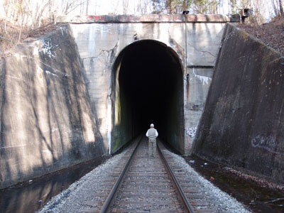
North Portal: (
BridgeHunter;
Satellite)
The tunnel goes under the Cumberland Mountain. The state border follows the ridge of the Cumberland Mountain.The north portal is in Kentucky whereas the south portal is in Virginia.
 |
| Bob Lawrence photo via TheTunnelDiaries-N via BridgeHunter, License: Public domain: Released by author |
The Aug 2022 issue of Trains is dedicated to railroading in Virginia. It includes an article that lists 25 "venerable places." #1 on that list was Hagans Switchback. I was shocked that a Class I railroad was using a switchback. (In the 1800s, switchbacks were common for logging railroads or for Class I railroads to get over a mountain until they got a tunnel dug through the mountain.) While looking for a topo map that shows the switchback, I found the tunnel that is just north of it
 |
| 1977 Middlesboro Quad @ 100,000 |
A train going geographically South through the tunnel would stop before hitting the dead end just south of US-58. It would then shove backwards up the curved track to the West and stop before it hits another dead end. It then continues East on a route along the Cumberland Mountain. My 2004 SPV Map shows that the route along the Cumberland Mountain that was west of this switchback was abandoned by Seaboard Systems. But CSX still owns this L&N route east to Stone Gap, VA. Note that the route heading East goes over the south end of the tunnel.
A photoshopped image showing one train going over another.
This cut on the south end probably looks fresh because CSX expanded the track to handle 110 car trains in 2010. [
csx]
And that expansion would explain the fresh-looking ballast on the west end.
Before expansion on the south side.
 |
| Global Earth, Oct 2008 |
Construction of the west end expansion.
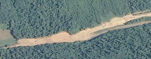 |
| Google Earth, Aug 2010 |


No comments:
Post a Comment