Locks: (
HAER;
Satellite, 332 photos)
Erie Canal Discovery Center: (
Satellite, 365 photos)
Erie Canal Overview
While studying
a steel+uranium+thorium mill, I noticed that a town named Lockport does have locks. And when I saw that it had flights of five historic locks and of two modern locks, it occurred to me that this must be where the Erie Canal crossed the
Niagara Escarpment. The flights raise the canal 60'.
The two modern locks were installed during a reconstruction in 1909-18. [
ErieCanal-1 photo caption]
 |
Photo by Edwin Polster via NYheritage
Also, ErieCanalway
"The Lockport Flight was one of the most challenging parts of the canal to build. The staircase of five sets of locks was blasted through the solid rock of the Niagara escarpment. The locks lift and lower boats 49-feet." |
A different exposure.
 |
Erie Canalway National Heritage Corridor posted
The Lockport Flight was one of the most challenging parts of the canal to build. The staircase of five sets of locks was blasted through the solid rock of the Niagara escarpment. The locks lift and lower boats 49-feet [15m]. #TBT #throwbackThursday 📸: Lockport Flight ca. 1880 |
 |
Sukini Ni posted
I have a lot of old postcards. 35 Years collecting. I have never seen this card. |
 |
Hudson River Lightkeeper commented on the above post
c1836 |
 |
Niagara History Center posted
This is an early image of the village of Lockport c.1836 before the Locks were enlarged in 1842. There are several similar but slightly different versions of this image. The first is dated 1830 and “Drawn from Nature” by W. Wilson which appeared in the History of the New York State Canal System published in 1906. Another, almost identical image, is a lithograph by J. H. Bufford which was based on Wilson’s drawing. It is dated 1836. This image is from the 1878 History of Niagara County and is labeled Winsor Del. It is based on the Wilson drawing but a key has been added to identify some of the buildings in the picture. |
Niagara History Center posted two images with the comment: "
An old stereopticon image of the Locks from about the 1870s. Stereopticons were the ViewMasters of the 19th century. A view of the Locks from a different perspective sometime after 1902 but before 1913."  |
| 1 |
 |
| 2 |
 |
Schoharie Crossing State Historic Site posted
The primary challenge in constructing the 363-mile-long Erie Canal was overcoming a total elevation change of 568 feet between the Hudson River and Lake Erie. This was accomplished through an ingenious system of 83 gravity-fed locks and 18 aqueducts. Canal locks function as "water elevators" for boats, using the natural force of gravity to raise and lower water levels in a controlled chamber. A boat enters the lock chamber through one set of gates. That gate is then closed, sealing the vessel inside. Valves are opened, allowing water to flow either into the chamber from a higher elevation to raise the boat, or out of the chamber into a lower section to lower it. The entire process is powered by gravity; no pumps were used in the original design. Water from the higher level naturally seeks its own level, flowing into or out of the lock until it matches the desired elevation. The original locks could manage an elevation change of about 10-12 feet each. To navigate larger vertical changes, engineers built sequences of locks, like a staircase. The most significant single obstacle was the Niagara Escarpment near present-day Lockport, a 70-foot cliff face. A former schoolteacher and mathematician named Nathan Roberts designed a solution. Using double set of five interconnected locks built side-by-side, allowing simultaneous up and down traffic. This "Flight of Five" was an engineering marvel and a major tourist attraction, giving the town its name. Image: postcard of Lockport, NY - Waterways Post Card Collection of Thomas T. Surprenant: Erie Canal, Graduate School of Library and Information Studies--Queens College (CUNY), New York, New York. |
 |
Erik Nordberg updated
This week’s cover is from a 1905 vintage postcard depicting the “flight of five” locks on the Erie Canal in Lockport, New York. They were refurbished and reopened in 2014 and give daily tours and weekly demonstrations of how they were designed to carry canal boats over the Niagara Escarpment.
[Erik provided five links to more information in the comments.] |
.jpg) |
LockportCave
[A reminder that the old barges needed a towpath along the canal. I noticed that on Google Maps the towpath is now the Empire State Trail.] |
 |
Gil Eaton posted
Life along the Erie Canal... Lockport 😎 |
 |
Gil Eaton posted
Life along the Erie Canal... Lockport 😎 |
Hudson River Lightkeeper
posted four images with the comment: "Celebrating 200 Years of the Erie Canal 1825-2025. Lockport"
 |
1
Hudson River Lightkeeper posted
Canal Favorites - Lockport
Blake Leibeck: what does it say on the building on the left side? Home of Wheatlet? what is that? I couldn't find any info on such a thing. Hudson River Lightkeeper: Blake Leibeck Wheatlet was a popular 19th-century wheat-based breakfast cereal introduced in 1885 by the Franklin Mills Company in Lockport, New York. Marketed as "All the Wheat that's Fit to Eat," it was developed by Charles E. Dickinson and produced in a historic four-story stone mill. |
 |
| 2 |
 |
| 3 |
 |
| 4 |
The southern flight has been replaced by two larger locks for the New York Barge Canal.
 |
HAER NY,32-LOCK,14A--7
7. OVERALL VIEW LOOKING SOUTHWEST TAKEN FROM RAILROAD BRIDGE LOOKING AT THE OLD AND NEW CANAL LOCKS. NOTE THE PINE STREET BRIDGE CROSSING OVER BOTH SETS OF LOCKS. - New York State Barge Canal, Lockport Locks, Richmond Avenue, Lockport, Niagara County, NY
"The historic flight is locks #67-#71. The New York Barge Canal flight is locks #34 & #35." [LocksDistrict] |
Niagara History Center posted two photos with the comment: "Photo of a boat locking through showing the need for an enlarged Erie Canal and locks to accommodate larger vessels. The other photo is from c.1930 showing the new and old Locks side by side."
 |
| 1 |
 |
| 2 |
 |
Gil Eaton posted, cropped
Life along the Erie Canal... Lockport 😎 |
 |
Satellite
The powerhouse near the bottom middle has a generator capacity of 4.867mw, but it has an effective capacity of 3.4mw because of the flow constraints. Average annual production is 10.8gwh. The canal is drained during the winter months. [LowImpactHydro]
The little green roofed building at the foot of the locks is the Locks District Museum. It was the original powerhouse. |
 |
Sue Wichers posted
Taken around 1920 by my grandparents (probably their honeymoon). Lockport, NY - locks 34 & 35.
[Actually, it is #34, #67 and #68.] |
Jake Jablonski
posted two photos.
David Schug: Was at 34/35 today myself.
PD Cappola: May 19 opening.
 |
| 1 |
 |
| 2 |
Ed Greenberg
posted four photos with the comment: "Some more photos from Lockport this weekend."
 |
| 1 |
 |
| 2 |
 |
| 3 |
 |
| 4 |
Photo 1 above shows the metal grid that they replaced with what looks like concrete slabs in this photo.
 |
1 of 8 photos posted by Gil Eaton
Life along the Erie Canal... Lockport. The old metal grid bridge couldn't handle the weight of some of the Canal Corporation heaviest equipment needed for Lock maintenance. Therefore the Corporation designed, built and is currently installing a new precast concrete bridge, all in house. From the look of it, excess weight will no longer be a issue. 😎 |
The 60' rise in the Niagara Escarpment presented a major engineering problem during the construction of the original Erie Canal (1817-25). It was solved by Nathan S. Roberts, who designed a double set of five combined locks; one for ascending traffic heading east and another for descending traffic heading west. Each lock was 90' X 15' and had a lift of 12' (an original drawing can be found at the Lockport Library), These locks helped to create the focal point for the development of the future city of Lockport.The first enlargement of the Erie Canal took place between the years 1836 and 1862. The engineer in charge was Thomas Evershed. At this time the canal prism was extended and the locks at Lockport were increased from their original size to 110' X 18'. This allowed an increase in the tonnage of canal boats from seventy five to two-hundred-forty.
From the years 1909 to 1918 the Erie Canal was modified to become the New York State Barge Canal. The southern tier of the locks at Lockport were removed and in their place was constructed a set of two electric lift locks. These concrete locks with steel gates were 310' X 45' X 12' and had a combined lift of 49'. The miter gates of the northern tier of locks were removed so the locks could be used for the passage of surplus water.
The above scene a month earlier, but with the gates closed.
.jpg) |
Gil Eaton posted
Life along the Erie Canal... Lockport 😎 |
 |
Gil Eaton posted
Life along the Erie Canal... Lockport 😎 |
The above views were on the north (old) site of the flight. The following view is on the south (new, about 1915) side of the flight.
 |
Danton Coulson posted
Between locks 34/35 and the flight of five beneath this grassy area is buried the remains of the east bound locks on the enlarged canal. beneath that is buried the original flight of five from Clintons Ditch. |
 |
| 1 |
 |
| 2 |
 |
John Kucko Digital posted
Footbridge on the Move: Amazing morning here in Lockport, NY along the Erie Canal. Barge one, transporting the pedestrian bridge to Buffalo and Ralph Wilson Park there, passing through the locks, then continuing to Buffalo. |
Construction of the 2-lock flight was started in 1909 when electric power was still rather new. These locks helped develop technology that was used in the Panama Canal.
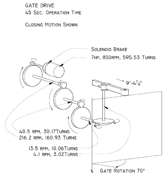
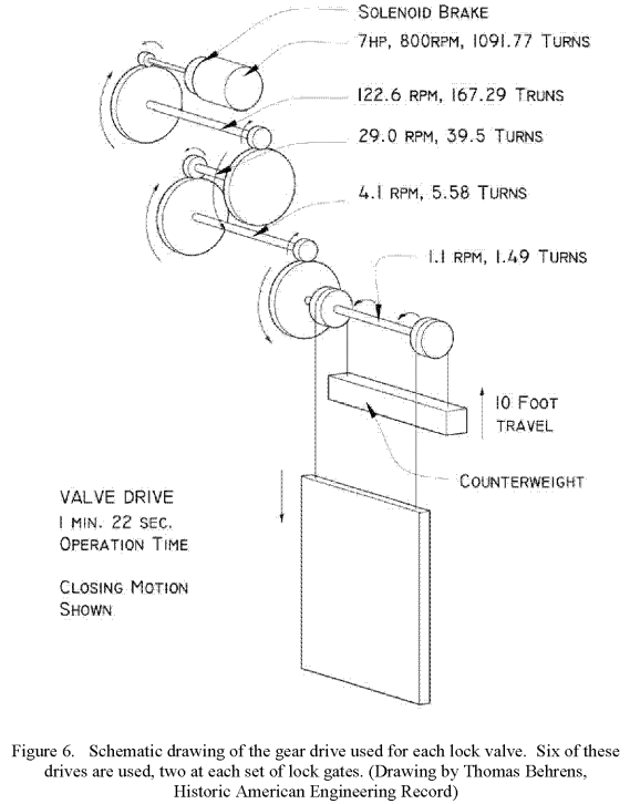
Starting on page
HAER-data, p110, is a sequence of diagrams that show how the water in one lock is used to fill the next lock. The diagrams shows that the old flight can handle three boats at the same time.
The Locks District Museum was the original hydropower plant.
I had noticed that the bridges upstream were not movable and that
they did not have a lot of clearance. So I had assumed that sailboats can't use the barge canal. But this photo taught me that they can as long as they stow their mast. This also shows a boat going from Lock #34 into Lock #35.
This photo caught a rather strong flow through the original locks.
 |
Uncovering New York posted
Riding through the historic Lockport Locks on the Erie Canal in Lockport, NY. |
 |
Gil Eaton posted
Life along the Erie Canal... Lockport 😎 |
 |
LockportJournal, Benjamin Joe, staff (source)
"Erie Barge Canal maintenance tour taker Brian Smith, CEO of Greater Lockport Development Corporation, points to the enormous space that is usually filled with water in Lock E34."
"According to a fact sheet provided by Canal Corporation, its parent, New York Power Authority, invests $140 million in the New York State Canal System each year for its overall operation, maintenance and capital improvements....E34 is the eighth Erie Canal lock drained this year. Each of the 57 locks in the system is treated to rehabilitation every 10 years."
[Judging by the bridge at the top of the photo, this is the downstream lock. The article indicates that the other lock is E35.]
|
.
Seneca Chief Sea Trials
Gil Eaton
posted four photos with the comment: "Life along the Erie Canal...
Lockport. Seneca Chief 😎"
 |
| 1 |
 |
| 2 |
 |
| 3 |
 |
| 4 |
Seneca Chief is "a traditional, full-sized replica of the Erie Canal Boat
Seneca Chief, which originally opened the Erie Canal in 1825." It was built from Oct 202 to Jun 2024. It is on a "Sea Trial" from Aug 9 to 18. [
BuffaloMaritimeCenter]
Jeff Tracy
posted 10 photos with the comment: "The
Seneca Chief was in Lockport this weekend. Before heading east towards Medina on Monday morning they maneuvered into historic lock 67 for some photo ops with the crew and volunteers from the Buffalo Maritime Center and the Lockport Locks Historic District."
 |
| 1 |
 |
| 2 |
 |
| 3 |
 |
| 4 |
 |
| 5 |
 |
| 6 |
 |
| 7 |
 |
| 9 |
 |
| 10 |
Danton Coulson
posted 12 photos with the comment: "I was lucky enough to watch the Seneca Chief negotiate the Lockport Locks for the first time Saturday. Going east through the locks was a little shaky, but coming back up everyone seemed to know the drill. They tied her up in the fore bay like they had been doing it all their lives. She will be in Lockport for sunday viewing and then it's on to Medina, Brockport, and Rochester and back. This is a great week for the western end of the canal so make your plans."
 |
| 1 |
 |
| 2 |
 |
| 3 |
 |
| 4 |
 |
| 5 |
 |
| 6 |
 |
| 7 |
 |
| 8 |
 |
| 9 |
 |
| 10 |
 |
| 11 |
 |
| 12 |
 |
Kay Green commented on Danton's post
This was Sunday [Aug 11, 2024] morning |
Lock History
The canal must occupy the route of a small river. We can see the short canyon that the river dug into the escarpment just downstream from the locks.
 |
| 1950 Lockport Quad @ 24,000 |
It is fun tracing the brown contour lines from Lockport to St. Catharines where the
Welland Canals crossed the escarpment.
 |
| 1952 Toronto Quad @ 250,000 |
The boat that shows up in many views is the canal inspection boat Lockport.
 |
HAER NY,32-LOCK,14A--41
41. AFT DETAIL VIEW OF THE CANAL INSPECTION BOAT LOCKPORT ON DISPLAY OUTSIDE THE ERIE CANAL MUSEUM, WHICH WAS ORIGINALLY THE LOCK-COMPLEX POWER PLANT. |
It is worth noting what mobile crane technology looked like before the hydraulic telescoping boom was developed. Note that it is using a clamshell.
 |
HAER NY,32-LOCK,14A--17
17. VIEW LOOKING NORTHEAST SHOWING THE TRASH GRATE THAT REPLACED THE LOCK GATES TO LOCK 71 WHEN THE FLIGHT OF FIVE WAS CONVERTED TO A SPILLWAY AFTER THE LARGER LOCKS, 34 AND 35, WERE PUT INTO OPERATION. THE SHOVEL TRUCK IN THE VIEW IS USED TO CLEAR DEBRIS. |
 |
| Lockport_Locks, this is one of many photos on this page. It is well worth a mouse click, or a screen touch or whatever verb one would use for a touchpad or a joystick. |
John Kucko Digital
posted four photos with the comment: "The Erie Canal at 200 (#35): Continuing my weekly series here on the page commemorating the bicentennial of the iconic Erie Canal. One of the most fascinating (and historic) locales along the entire Erie Canal is Lockport, NY in Niagara County. The city got its name from the series of Erie Canal locks (now Locks 34 & 35) that allowed canal boats to overcome the Niagara Escarpment. Originally, there were five locks here—the Flight of Five—which later gave way to the two locks there now. This area has been wonderfully cared for and much of the original Erie Canal history has been beautifully preserved—a great learning experience can be had in Lockport. Last summer, I captured the massive
pedestrian footbridge here on a barge making its way to Buffalo, having been pushed the entire length of the canal. Before that, a few years ago, I documented the sailors from Russia as they circumnavigated the globe on their homemade wooden boat. I captured them in many spots, including here. Lockport, NY is among the finest spots along this historic waterway—I highly recommend a visit here."
 |
| 1 |
 |
| 2 |
 |
| 3 |
 |
| 4 |
 |
John Kucko Digital posted
Flight of Five: AMAZING day at the iconic Erie Canal locks in Lockport, NY as part of the 2025 World Canals Conference in Buffalo. We had daylong field sessions today and I chose Medina and Lockport. Wonderfully educational and spectacular—I saw things I never experienced before. The Flight of Five, a five-step staircase lock, is truly amazing and the demonstrations are wonderful! World Canals Conference NYS Canal Corporation |
 |
Lee Williams commented on John's post
| There is literally nothing like the Flight of Five locks anywhere!
|
 |
Karen Limardi commented on John's post
I was there on Thursday [Sep 18, 2025?] ! |
John Kucko Digital
posted four photos with the comment: "Lockport’s Legacy: Here at the 2025 World Canals Conference in Buffalo and today was a day for field sessions where several busses took visitors from across America and the world to various places along and around the iconic Erie Canal. I had my pick of any tour and I selected the one that would take me to Lockport, NY for pretty much most of the day. This was superbly coordinated, as all the field sessions were. Lockport is a place I’ve been to before, but my stops were quick ones as I was chasing boats. This time I got on one—a terrific ride with Lockport Locks & Erie Canal Cruises. They took us through the double locks (Locks 34 & 35). And this was after we had a fabulous lunch at their place. I saw lots today and will post content in the coming days. From extraordinary Tiffany Glass at a local church to the terrific Erie Canal Discovery Center & Lockport Visitor Center. We topped it off with a wonderful dinner at Big Ditch Brewing Company in Lockport. My most impressive takeaway today is this: Lockport had loads of volunteers, local folks passionate about their community and eager to share it with lots of visitors. This is a very special city and I’m glad I selected it to be my focus for the day. Lockport, NY was a wonderful place to be today! NYS Canal Corporation World Canals Conference"
 |
| 1 |
 |
| 2 |
 |
| 3 |
 |
| 4 |
John Kucko Digital
posted six photos with the comment: "The Erie Canal at 200 (#41): Continuing my weekly series here on the page commemorating the bicentennial of the iconic Erie Canal. In Lockport, NY are Locks E34 & E35, as well as the iconic Flight of Five stone locks, plus a terrific Erie Canal Discovery Center and Lockport Visitor Center. In other words, they have all sorts of neat spots to visit and learn about this historic waterway. These are various captures of mine from a recent visit there. The vintage replica vessel, the Erie Traveler, was built in 2017 for them to demonstrate the manual operation of the Flight of Five Locks. Volunteers operate the vessel as part of scheduled demonstrations on Saturdays during the canal season to showcase the historic process of manual lock operation to visitors there. The Discovery Center is amazing—including a short film that puts you in a lock, virtually, it was very well done! The Lock Tenders Tribute Monument is a series of life-size sculptures honoring canal workers, wonderfully created by artist Susan Geissler. Lockport is a terrific place to visit and immerse yourself in all things Erie Canal."
 |
| 1 |
 |
| 2 |
 |
| 3 |
 |
| 4 |
 |
| 5 |
 |
| 6 |
 |
Lucas Maverick posted
Footbridge on the Move: Amazing morning here in Lockport, NY along the Erie Canal. Barge one, transporting the pedestrian bridge to Buffalo and Ralph Wilson Park there, passing through the locks, then continuing to Buffalo |
 |
Craig R. Bruver posted
Lunch today [Feb 13, 2026]. |
Gil Eaton
posted three photos with the comment:
Life along the Erie Canal...
Lockport. Wood decking at the Flight of Five. 😎
[They can't drain the canal completely in the Winter.]
 |
| 1 |
 |
| 2 |
 |
| 3 |
.jpg) |
Albert McFadyen posted
Opening a lock on the Historic Erie Canal.— in Lockport, NY.
[The the High Bridge in the background.] |
The canal is still drained for the Winter.
 |
Bobby Gelser posted
Walk with me as I explore the Erie Erie Canal's flight of five in Lockport, NY. What a cool place to explore. |


.jpg)


.jpg)


.jpg)

No comments:
Post a Comment