Wednesday, December 4, 2019

CB&Q Freight Houses and Team Tracks with Gantry Cranes

The CB&Q had "Central Warehouses" south of Union Station. These notes examine the evolution of CB&Q's support freight houses.

In 1929, the team tracks went all the way between Union Avenue and Canal Street south of the east end of their Western Avenue Yard. And I note that rail service still went south of 16th Street into the Schoenhofen Brewery.
1929 Englewood Quadrangle @ 1:24,000

<update>
Erie had a terminal with CB&Q so CB&Q's freight facilities show up on Erie's map.
DavidRumsey

DavidRumsey

DavidRumsey
</update>

By 1938, the freight house on the right was removed to move the Jefferson Connection further south to expand the CB&Q Commuter Coach Yard. The freight facilities above the St. Charles Air Line embankment were owned by C&NW.
1938 Aerial Photo

By 1941, a gantry crane was added to transload heavy shipments between trucks and freight cars.
79., 1941, cropped
CB&Q tracks (left) - CB&Q freight houses -16th and Union sts.) (far left)

By 1948, a gantry crane was also added to the west side of the Western Avenue Yard.
Gary Hosek commented on his post
Lou Gerard All the suburban Pacifics!

Gary Hosek posted
Coal piles - Western Avenue yards - Chicago - May 1948 - Russell Lee photograph.
Dennis DeBruler This photo confirms that CB&Q had a gantry crane west of the coaling tower. The May 1948 date indicates the crane existed after WWII.

This gantry crane also appears to have been built after the 1938. The long east/west building near the center of the top half of this aerial of the west side of Western Avenue Yard has been removed by 1948.
1938 Aerial Photo

Also by 1948, CB&Q had replaced some rail serviced industries with a newer freight house southwest of the western end of the Western Avenue Yard.
Gary Hosek posted
Freight cars - Western Avenue rail yards - Chicago - 1948 - Russell Lee photograph.
Dennis DeBruler It shows the top of the round CB&Q coaling tower near the left of the background.
Rick Aylsworth Less-than-carload freight terminal. The boxcars are spotted with their doors aligned so planks can be placed across between cars, allowing all cars to be reached from the dock.
Raymond Barr Took a strong back to push freight from track 4 to the dock ..

Dennis DeBruler commented on Ean's comment on Gary's post
There used to be some railroad served industries there.
https://clearinghouse.isgs.illinois.edu/.../0bwq08046.jpg
Looking at USGS Englewood quadrangles, the 1953 map still has the 1938 bildings, but the 1963 map shows the new freight house buildings that Lee's photo shows existed by 1948.

The 1953 topo map still shows the old rail-served industries, but...
1953 Englewood Quadrangle @ 1:24,000

...the 1963 topo shows the industries, and roundhouse, are gone. Not only does it show the freight house in Gary's photo, it shows the roundhouse was replaced by a freight house.
1963 Englewood Quadrangle @ 1:24,000

In fact, the freight house that replaced the roundhouse is still standing!
Satellite

But the weeds indicate it has not been used recently. I wonder if the roundhouse, ash pit, etc. contaminated this land so that now it can't be used without a lot of cleanup expense after they tear down the freight house. That would explain why the freight house still stands as a monument to when trains, not trucks, hauled non-bulk freight.
Street View

BSNF still claims that they have an intermodal yard here. But it is obvious that it is now just a parking lot.
Street View

More details concerning the freight house in Gary's photo above.
David Daruszka commented on Ean's comment on Gary's post
From the Sanborn maps.

They have torn down the buildings, but they haven't bothered to remove the concrete floors and paving.
Satellite

I happened to take a photo of this vacant lot when I heard a commuter train on the BNSF mainline. Is this land also contaminated?
20180812 3488
Looking North from 19th Street west of Western Avenue.

The land used by the freight houses on the east side is now an expressway and residential units.
3D Satellite


The 1963 topo shows the buildings have been removed between 19th and Cullerton Streets. I took this photo of the building on the south side of 19th Street because of the two water towers. That building has had the windows remodeled, but I don't think it was built since 1963.


And we can still see railroad tracks for an industrial spur in the lower-left part of that block.
3D Satellite
I can believe that the building on the east side of that block was built in the 1960s.
3D Satellite

Marty Bernard posted
Looking Out Union Avenue Tower's East Windows
Union Avenue Tower was at the west end of the wye south of Chicago Union Station. It was a CB&Q tower. This photo from August 1, 1963 is looking through the east windows of the Tower. We see the Dan Ryan Expressway above the tracks and Union Avenue below, going under the tracks. The rolling stock left to right is Train 123's Motor under the Dan Ryan, Train 133 heading west, Train 23's Motors (the Afternoon Zephyr) and GM&O Train 2 (the Abe Lincoln). "Motor" is what a diesel was called by the tower man and the dispatcher. Trains 123 and 133 were Dinkys. The Abe Lincoln is being turned on the Wye. Above Train 133 you can see the St. Charles Air Line taking off.
My guess "motor" was to distinguish diesels from steam. Union Avenue Tower is long gone. It was the start of the Q's Racetrack.
[Mark Hinsdale pointed out the freight house on the right side of this photo.]

Chris Goepel posted
Have a question about a bit of CB&Q history on the Lumber District in the Pilsen neighborhood on Chicago’s West Side.
An old CB&Q map I recently stumbled upon identified a long narrow building along the east side of South Morgan Street immediately south of West Cermak Road as a CB&Q-owned freight house served by local trains on the Lumber District. Does anyone know if this building pictured, with some recent years modifications and updates and now occupied by Meade Electric, is that freight house, or if the freight house was another building now demolished?
I used to live not far from here, yet believe it or not, I’ve never been able to find any historic photographs that help reconcile this question. Any insights appreciated.
Photo Copyright 2024, Chris Goepel.

Jon Roma commented on Chris' post
See the attached, which is from the 1914 Sanborn fire insurance atlas covering this part of Pilsen. I've rotated it so that north is at the top.

Jon Roma commented on Chris' post
For reference, here is the Sanborn page for the adjacent area north of 22nd St. (as Cermak was known at the time.)

Dennis DeBruler commented on Chris' post
I don't think the Meade building was a CB&Q freight house. A 1953 topo map shows that area was mainly tracks like the Sanborn Map shows. A 1963 topo map shows new buildings in that area. Those buildings were like these in a 1997 Englewood topo with a scale of 1:24,000. Google Earth shows that today's building existed as of Mar 1999.

Dennis DeBruler commented on Chris' post
This 1952 aerial photo shows that the 1953 topo map is wrong. CB&Q had built their freight house by 1952. [AR1SA0000040037]
Chris Goepel: Dennis DeBruler appreciate the insight. I zoomed in on the notations on the CB&Q outbound freight house in the mid-1950 Sanborn posted in this discussion, and it appears to read that it was constructed in 1950.

1953 Englewood Quad @ 24,000

Tuesday, December 3, 2019

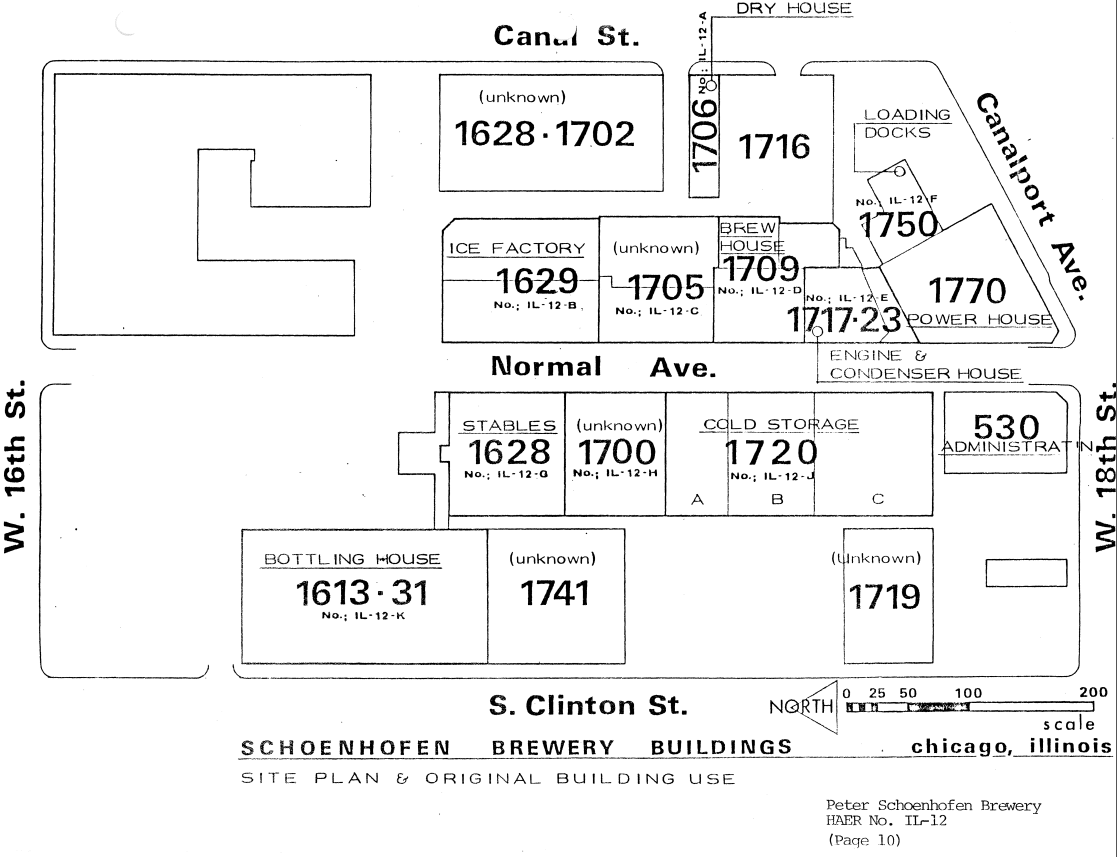
Peter Schoenhofen Brewery (Edelweiss Beer) in Chicago

(HAER; see below for satellite image)

(Update: ChicagoLandmarksa history with several images including a closeup of the water tower; ForgottenChicago)

This brewery had a water tower shaped like a beer bottle, which shows up in several railroad photos. Their flagship brand was Edelweiss.

David Daruszka posted
Bob Lalich That is a beer bottle from the Schoenhofen brewery. 

David commented on his photo
That bottle water tower shows up in a lot of pictures.

Gary Hosek posted
Westbound passenger train - Halsted Street Station - Chicago - May 1948 - Russell Lee photograph.
Eric Reinert The beer Bottle water tower of the Schoenhofen brewery is visible as well.

Daniel Herkes commented on Eric's comment on Gary's post

Daniel Herkes commented on Eric's comment on Gary's post

HAER-data from il0068
I put a red rectangle around the brewery buildings that are still standing. The yellow rectangle indicates a building that is still standing, but it was not part of the brewery.
Satellite

The admin building is on the left and the powerhouse is on the right. The powerhouse has the 1600' well in its basement, and it represents the Second School of Chicago Architecture.
Street View
It appears the brewery used to be rail served by the CB&Q.
1929 Englewood quadrangle @ 1:24,000

MWRD posted

MWRD posted
A view to the north showing the South Branch of the Chicago River on August 10, 1900, with a portion of the old Canal Street Bridge visible at right.

Dennis DeBruler commented on MWRD's post
The Schoenhofen Brewery must have built their powerhouse between 1900 and 9104. In the above photo, note the grain elevator just to the left of the superstructure for the Canal Street Bridge. In the 1904 photo below, the powerhouse is just west of that grain elevator.
The powerhouse still stands today:

Steven J. Brown posted
PRR South Branch Lift Bridge (built 1913) and the Schoenhofen Brewery viewed from 16th Street and Normal Avenue in Chicago, Illinois - April 1, 1988.

Earl Camembert commented on MWRD's post
Dennis DeBruler: In the right background is an incredible view of what the Schoenhofen Brewery used to look like. We can see one of the buildings that is still standing in Earl's Street View.


VintageTribune photo of an ironworker drinking an Edelweiss on the job

VintageTribune photo shows the Sky Tower that the ironworker was on


Monday, December 2, 2019

1904,43 Long (14th Street ) Bridge over Potomac River at Washington, DC

(Archived Bridge Hunter is broke; Bridge HunterHistoric BridgesSatellite)

The B&O first used a bridge at this crossing. But a Pennsy subsididary, Baltimore & Potomac, won control of it in the 1870s. CSX now owns it and Amtrak and Virginia Railway Express (commuter trains) also use it. [AmtrakDCNRHS]

DDOT via ggwash

A predecessor bridge.
Ron Tutt posted
Crystal City is not a neighborhood one would necessarily call historically rich, unless you’re into the history of buildings with the name “crystal.” There is, however, a certain landmark in Crystal City which (sorry, pun intended) connects us to the past: The Long Bridge. Since the founding of America, there was a need to have a way to cross the Potomac to reach the disconnected part of the Capital, which is now Alexandria. The bridge opened in 1809 and, after being partially destroyed by British fighting, reopened in 1816. Congress purchased the bridge in 1832, and during the Civil War, it became heavily protected by the Union because of its easy accessibility to the White House. After that, the bridge had its share of successes and failures; it was damaged by floods, used as a railroad and an interurban trolley line, almost destroyed by fire in the 1960s, and today is memorialized as the site of Long Bridge Park.
Shown below: Civil War era photo of the Long Bridge by Andrew J. Russell.

dkeg via Amtrak

DDOT via Executive Summary via DIES via LongBridgeProject

This bridge was rehabilitated in 1942-43 by replacing the truss spans with girder spans except for the swing truss.
National Photo Company collection, Library of Congress via Bridge Hunter
Passenger train crossing Potomac [Long Bridge] July 2, 1925

When I-395 was built upstream, it blocked the swing span from opening. So it was last used March 3, 1969. I noticed that the Charles R. Fenwick Bridge is now even closer. It is for Metrorail's Yellow Line.
William A. Shaffer added
Crossing a River
The "Cardinal" has just crossed a river with Washington's skyline in the background. (Photo by William A. Shaffer)

Given that Washington is in the background, the river is wide, and there is a swing span in the bridge, it was pretty easy finding the bridge. Bridge Hunter normally lists predecessor railroads. But not in this case. My best guess based on my 1928 RR Atlas is Southern. Looking at a route map confirms that the Cardinal does goes rather far south before it starts working its way north to Chicago.

Interactive Map
Then I remembered that this route was formed to make a powerful senator happy. I think it was a West Virginia senator. The fact that CSX gutted the B&O across southern Ohio is probably what forced rerouting the Cardinal.

Marty Bernard posted
Now You Know Why You Don't See Many Train Photographs on this Bridge -- What Train?
AMTK 268 with Train 89, The Palmetto, crossing the Potomac River at Washington, DC on September 12, 1983.


The two tracks on this bridge are at capacity. Not only would CSX, Amtrak and VRE like to add more trains, NS and MARC would also like to run trains between DC and Virginia.

Image by DDOT

CSX rehabilitated this bridge in 2016. So the proposed solution is to build another two-track bridge just upstream of this one. And also build a trail (pedestrian and bike) bridge upstream of that one. The new RR bridge is expected to be a steel girder bridge and cost $1.3 to $1.6 billion and take five years to build. The cost for the trail bridge is expected to be significantly lower.
Image by DDOT
The trail bridge is mitigation. While trying to figure out what problems the trail bridge is mitigating, I think I figured out why this bridge would cost over a billion dollars. They have to expand the right-of-way on the DC side from two tracks to four tracks. This requires replacing all of the overpasses between the river and Maryland Avenue. But then the four tracks funnel down to three tracks between there and E St SW+2nd St SW where the passenger and freight lines separate. There does appear to be four tracks on the Virginia side. The red dots in the following diagram show the replacement overpasses that have to be built as part of this project.
Project Study Area
The trail bridge mitigates "direct property impacts to Long Bridge Park, GWMP, and East Potomac Park" [Executive Summary via DEIS]

The estimated cost has already risen to $1.9 billion. [WashingtonPost] Hopefully, that would be because the cost now includes the cost of the trail bridge.

Update: It sounds like Virginia is paying $3.7 billion for the project but will then own the two new tracks.  (source)
Another report about the $3.7b deal, which has more information. 
And another report (source)

safe_image for Long Bridge project poised to advance to design phase
"
The $1.9 billion project now is eligible for additional federal financing opportunities. The new bridge accounts for a large chunk of the $3.7 billion Transforming Rail in Virginia initiative, which is financed through local, regional, state and federal sources, including a $944 million partnership with Amtrak."

Update: federal funds are being used  to replace a 2-track overpass with two 2-track overpasses south of this bridge.

safe_image for An early look at plans for new rail, pedestrian bridges over the Potomac
A rendering of the proposed rail bridge over the Potomac River between Arlington and Washington. Virginia is advancing a plan to build a new two-track rail bridge to significantly expand commuter and passenger train service within the decade. The new bridge would align about 40 feet north of the existing two-track Long Bridge, which carries freight and passenger trains between the nation’s capital and Virginia. (Virginia Passenger Rail Authority)
"The $2 billion rail project between D.C., Virginia is on track to double capacity over the Potomac River by 2030"
[Before I read the whole article, it disappeared.]
William Novak: As a consultant I worked on the early planning stages of this project that involved capacity and operation modeling and analyses as well as minor track capacity enhancements on each end of the project corridor. Completing the proposed bridge will eliminate the largest existing bottleneck on the DC-Richmond corridor.


Sunday, December 1, 2019

High Winds and Waves on Lake Michigan, Nov 27, 2019

We had sustained winds up to 60mph in the Chicago area and much of the Midwest. Soon after, I saw the following posts on Facebook. Because we have had a very wet Spring and Fall, Lake Michigan is at a near record lake level. So high waves on top of that high lake level are causing more problems with our infrastructure. For example, Lake Shore Drive gets flooded much more often than it use to.

This damage is a reminder of the "gales of November" that sunk the Edmund Fitzgerald.


Mackinac Island Ferry


Mackinac Straits Photography Gallery posted
Sara Raine It was a decommissioned boat used for advertising. The engines and everything have been stripped out.


Mackinac Island


WJML posted
Mackinac Island Road COLLAPSED.
A portion of M-185 on the northern tip of Mackinac Island crumbled after rain and high winds this week. (Photo: Jason St. Onge, Special to the Free Press) via Detroit Free Press
[According to some comments, the initial collapse happened in Oct. and then the Nov. storm caused more damage.
Mackinac Island is famous for not allowing cars on the island. But I see from the comments that this road was intended for horse carriages, bicycles, golf carts, emergency vehicles and (during the off season) road repair vehicles.]
Colleen Peterson James Bruns People have lost the width of a football field in the last year in Michigan. The high water has been unreal.
Phillip Callighan Was this the same road that VP Pence & his convoy of vehicles used for a recent visit?
Ron Fulger No, only interior island roads by airport.
Wayne Frazier They couldn't afford the DEQ expert 2 come out and give them the recommendations for what they needed to do to shore up a silt fence inorder to get the proper paperwork and permits on the needed environmental survey and wildlife impact study required to move forward with a engineering plan for a proposed seawall? I mean all they had to do was jump through a couple of more hoops after that... And set aside 500 acres of land for some <expletive> snail that may have shown its head around there once or twice... Come on guys this was easy to avoid.
Colleen Peterson It’s been all along Lake Michigan, Lake Superior and Huron! People are having houses fall into the Lakes. The water is so high and the Lakes have had 10’ to 25’ waves this year.


Mackinac Bridge

Winds forced bridge authorities to require big vehicles — including campers, cars hauling boats, bikes and luggage, and tractor-trailers — to require an escort.
Motorists headed to and from the Upper Peninsula over the bridge in cars, pickups and vans are required to reduce speed to 20 miles per hour and be prepared to stop, said an alert from the Mackinac Bridge Authority.
[Detroit Free Press]
I can't figure out how escort vehicles are going to help. Unless they force the "convey" to drive even slower than 20mph. I accessed the above link on Nov 30, 2019 and got the following alert:  "Examples of vehicles which are especially vulnerable to high winds are pickup trucks with campers, motor homes, vehicles pulling trailers and enclosed semi-truck trailers. Motorists are instructed to reduce their speed to a maximum of 20 miles per hour, turn on their four way flashers, and utilize the outside lane. Motorists are asked to exercise appropriate caution."

Ludington, MI


Two of eleven photos of concrete covered with sand and water posted by Tom Sanders.
a
[I choose this photo because it shows the natural dunes that got removed because, in spite of warnings from the community that it would be destroyed, the city honchos decided to build a playground and parking lot by the lake. If you look at the damage done in Tom's other photos, as predicted by the community, the taxpayer's money was effectively thrown into the lake. Another demonstration that "community input" meetings are worthless because the input is ignored. According to the comments, the community was also vocal in the media as to the viability of this park.]

b
[From the comments, I believe this photo was taken here looking East.]

Scott Kelsey posted
David Skridulis Are the benches gone?
Scott Kelsey David Skridulis looks like it.

This town also suffers river flooding.