These are notes that I am writing to help me learn our industrial history. They are my best understanding, but that does not mean they are a correct understanding.
After $823m and 7 years, this 1925, 220' tall dam has been rebuilt to safely store 31 billion gallons of water during earthquakes up to a 7.25 magnitude on the Calaveras Fault that runs 1500' away.
(new window) Possible failure due to a local fault line was identified in 2001. It was supposed to cost half as much and be done in four years. (source) The reservoir has been kept below 40% capacity since 2001. [SFchronicle]
When they started removing the side of the hill near the end of the time-lapse video, I was wondering if that was a planned borrow site or if they were reducing the risk of a landslide. I found my answer. Removing that hillside was evidently not part of the initial plan. "The reason for the delays? Once they started digging, construction workers found two ancient landslides in the 20 million-year-old geologic layer cake nearby, forcing them to carve away millions of tons of rock and sediment to better anchor the new dam on more solid footing. They also had to shore up hillsides more than expected, and were delayed three months during the flooding winter of 2016-17....Outside experts say the delays were an unfortunate, but unavoidable, reality." This is the largest of the five reservoirs that supply water to the Bay Area. "The clay core and other features of the new dam will allow it to be raised 150 feet some day, if future generations decide [They can decide how much they want to pay for steelhead trout and/or more water.], which would quadruple the reservoir’s size." This rebuild is part of a $4.8 billion earthquake hardening effort of the Bay Area's water supply initiated in 2002. Some people's water rates have tripled. "The project also gained attention after the roughly 300 workers began digging up huge teeth from Megalodon sharks 20 million years ago, along with hippo teeth, fossilized palm trees and whale skulls. They all were donated to the UC Berkeley Museum of Paleontology.
Before San Francisco was required to upgrade the Hetch Hetchy system, studies showed a major quake could cut off water for 60 days, causing significant health problems and fire risks. Now, the system is strong enough so that 70 percent of customers will have water within 24 hours after the Big One." [MercuryNews]
They not only had to lower the risk of new landslides, they added buttress fill to stabilize an existing landslide. [SFwaterFacts]
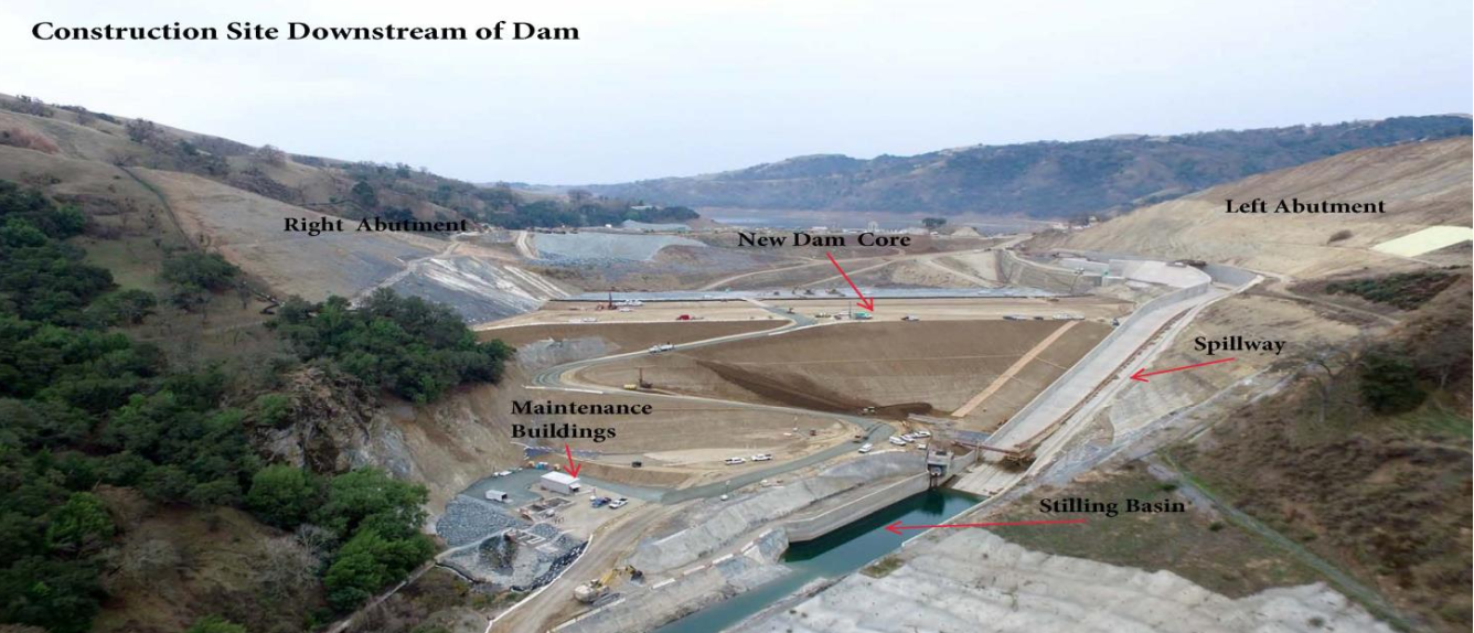
While looking at the time-lapse video, it appeared that they dug away part of the old dam to make way for the new dam. But the following explains they built the new dam a little downstream of the old dam.
San Fancisco Public Utilities Commission
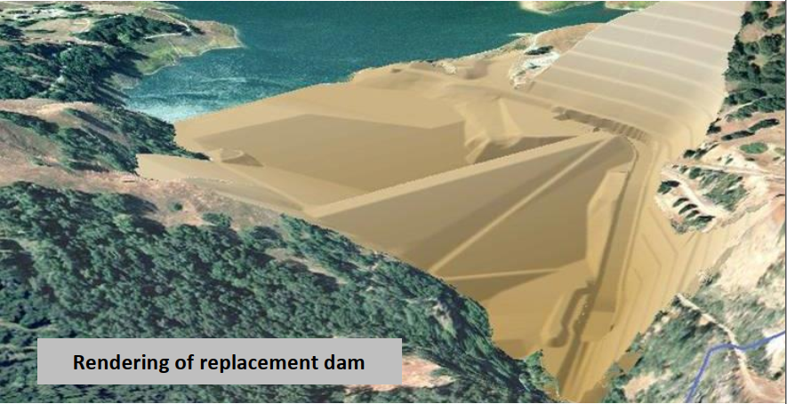
It is interesting comparing the initial rendering to a Spring, 2018 photo.
In the rendering, there seems to be essentially a cliff next to the base of the spillway. In 2018, not only is that cliff gone, a cover has been put on top of what remains. And notice that they did not merely step the left abutment, they significantly reduced the slope of the abutment.
I wondered why I could not see the end of the outlet empty into the stilling basin. Evidently the outlet pipe goes directly to the Sunol Valley Water Treatment Plant. The new dam has a new intake/outlet tower that is 20' in diameter and 163' deep. The input is a 72" steel-lined tunnel and the output is a 78" pipeline. [WaterTechnology] The treated water must be delivered to the Bay Area via an aqueduct. They want to make sure they don't loose a drop of the transported water to evaporation, etc. Even though the dam is 220', I can find no indication that they recover hydro power from the output.
A discussion of the inlet/outlet structures for the new dam mentioned three tunnels. It looks like they may now have an emergency outlet to the river in addition to the78" pipeline to the water treatment plant. Specifically, note the structure just to the left of the spillway base in this image.
PDF Zoomed
They did remove the old spillway, but at 40% capacity, it would not have been used since before 2001 anyhow. But they also removed the toe of the dam because they exposed the original outlet pipe.
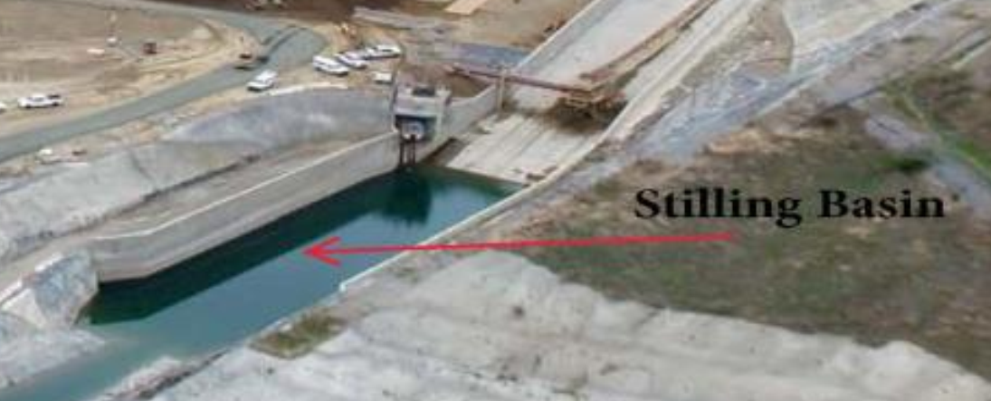
The problem with a fast time-lapse video is that I did not catch them building the outlet pipe. They used the old stilling basin a couple of times before it was covered up.
When I read about a landslide somewhere else in California a few years ago, the article explained that, because of the many earthquakes, the bedrock was "incompetent." The article gave as an example that even the granite mountains can't be climbed using pitons because the rock won't reliably hold them. So I was not surprised that this project included 100' deep grout walls in the foundation and abutments. But I was surprised that building the spillway on bedrock was not sufficient. "Construction crews drilled 1,825 anchors approximately 25 feet into the rock around the spillway to provide
support and prevent damage to the structure during a 7.25 maximum credible earthquake on the Calaveras fault." [SFwater-spillway] There not only was a landslide in 1918 when they were building the original dam [ucdavis], there was a landslide this year [2018] that closed the Calaveras Road! [SFwater Project Update] In contrast, the bedrock in Illinois is very competent. That is why we can feel earthquakes in Southern Illinois up here in the Chicago area.
I finish by firing up Global Earth and capturing images from 2011 to April, 2018
May 2011
Jan 2012
May 2012
Aug 2012
Jun 2013
Mar 2014
Nov 2014
Jun 2015
Oct 2015
Apr 2016
Aug 2016
Jan 2017
Mar 2017
Aug 2017
When I move the slider, I see times for 1/2018 and 2/2018; but when I release the mouse, the slider moves back to 8/2017. So I'm going to have to end with the last one currently displayed.


No comments:
Post a Comment