William Shapotkin asked about the "Forest Park Branch" of the Illinois Central:
The Illinois Central once operated a line, which I understand was known as the "Forest Park Branch." The line began at "Parkway" (26th St west of Harlem Ave in North Riverside, IL) and headed north connecting with the present-day CSX (of course, we know it as B&OCT) just north of Harrison St in Forest Park, IL. The IC referred to the north end-of-line as "Harlem Jct," the rest-of-the-world referred to it as "Great Western Jct."The line is now abandoned -- but some eight years ago, I was able to follow and photograph the line from Parkway north to 15th St (where the track ended). Does anyone know when the line was removed north of 15th St? Courtesy of a fellow (Bob Lalich), we know the line was still intact as of 1942 (see track chart below). If anyone can shed some light (and even better a few photographs) of that line north from 15th St -- MORE ESPECIALLY the at-grade xing of the IC and the Chicago & West Towns streetcar line at Roosevelt Rd (aka "12th St"), it would be greatly appreciated.Many thanks.
 |
| Provided by Bob Lalich |
David J. Leider explained:
The original name for the line was the Riverside & Harlem Railroad. It was used by the Wisconsin Central to get to the IC's lakefront station. The WC was going to build the line, but the IC insisted as they wanted to gain access to the Harlem Racetrack, which was just west of the Right-of-way. The line was incorporated April 10, 1901. Capital stock $200,000. The Village of Harlem granted them an ordinance to build the line on July 5, 1901. It was open August 30 after a skirmish with the Chicago Terminal & Transfer about crossing its tracks. The IC purchased the line October 1902.
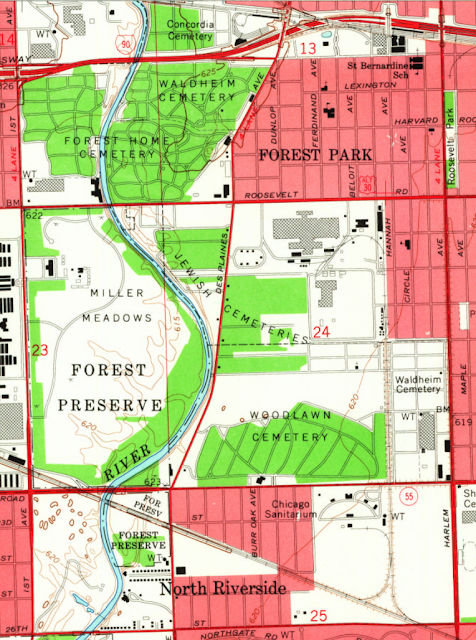
This 1953 topo map shows what the branch looked like when it was intact.
1953 Berwyn Quadrangle @ 1:24,000
 |
| Provided by Dennis DeBruler |
By 1963 it had been cut back so that it no longer crossed Roosevelt Road.
1963 Berwyn Quadrangle @ 1:24,000
 |
| Provided by Dennis DeBruler |
By 1972, a spur had been added for an industrial park north of Woodlawn Cemetery. The track configuration was the same in the 1980 map, but there were more buildings in the industrial park.
1972 Berwyn Quadrangle @ 1:24,000
 |
| Provided by Dennis DeBruler |
By 1993, the tracks had been removed by the Forest Park Mall.
1993 Berwyn Quadrangle @ 1:24,000
 |
| Provided by Dennis DeBruler |
The last map available is 1998, and it still shows the track going north of 15th Street. I noticed that today none of the buildings in the industrial park have rail service because the track south of 15th Street has been removed. Today there is more track on this branch north of 15th Street than there is south of it.
 |
| Provided by Dennis DeBruler |
The guy that drove the Google street car in this area must have been a railfan.
 |
| Provided by Dennis DeBruler |
Matthews and Mann provide some insight into the industry that used to be along that branch.
 |
Andre Kristopans explained that when SOO (one of the many corporate names for this Wisconsin Central route) moved from Central Station to Grand Central Station, it no longer used this route. "When they went back to Central again (early 60s?) they used IHB down to Broadview."
I've lived in the western suburbs of Chicago for over four decades and never heard of Broadview. Looking at a map, I see I drive by it every time I'm willing to test the severity of the traffic jams on I-290. I highlighted in red the IHB route used to connect WC/CP/SOO/WC with IC.
 |
| Satellite plus Paint |
I actually saw a freight cross Roosevelt Road in 1971. There was Purple Martin gas station where it ran past its large billboard.
ReplyDelete