 |
| Niagara Action posted An aeriel view of Niagara Falls taken around 1922. Jim Myers shared |
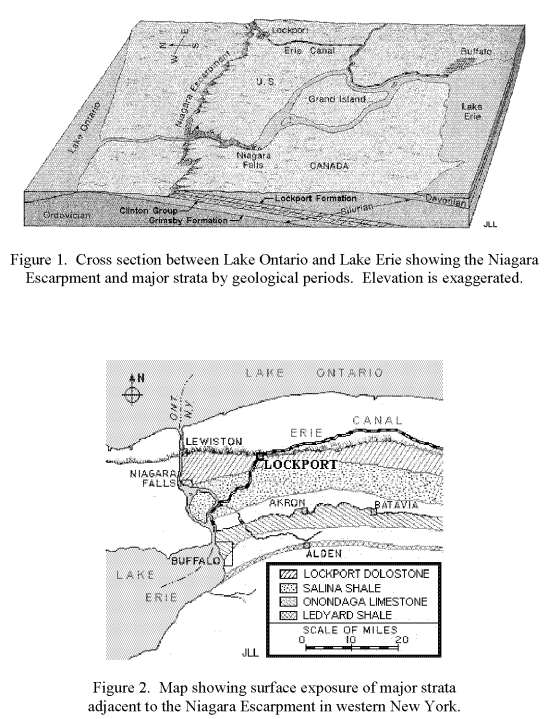
The first factoid to consider is the Niagara Escarpment. It is the exposed edge of the Niagara dolostone sedimentary layer. The dolostone is harder than the shale layers that surround it. So it has resisted the erosion that has removed the neighboring rock. It is responsible for the Door Peninsula, the west side of the Georgian Bay and the cliffs that cut across Ontario.
 |
| CC BY-SA 3.0, Link |
This diagram shows the hard cap stone.
 |
| John Vencent posted via Dennis DeBruler |
Look at the last figure in geomich to see how the sedimentary layers were bent into a shape of nested bowls under lower Michigan. Those "bowls" explain the circular shape of the Niagara outcroppings. When you consider that the quarries in Lemont, IL, and Bloomington, IN, are also in the Niagara seam, you see an even more complete circle.
Unfortunately, this map got cut off on the Illinois side.
 |
| Amber Pacquin via Dennis DeBruler |
 |
| Bruce Verbeck posted The Niagara Escarpment, this is why there is a Niagara Falls. Paul McRoberts: It's Grimsby. Deanna Donelson shared Mark J Stachowski: I forget the details, but that was essentially was the depth of Lake Ontario at one point in time. Jason Ramsay: Lake Iroqouis |
The Niagara layer was deposited about 430 million years ago. [wgnhs]
 |
| HAER-data, p15 |
I used Street View to find evidence of the escarpment in St. Catharines. This shows how the road goes up a hill and the houses in the distance are significantly higher. This taught me that a line of trees on the satellite map is the escarpment.
 |
| Street View |
A second factoid is that the Welland Canal has three locks in a row (#4-#6) and another close by (#7) that raise ships about 60m (200').
A third factoid is that The Second Welland Canal had Neptune's Staircase just west of the current 3-flight locks (#4-#6).
I know how to access topo maps for the USA. But I don't know how to do it for Canada, or I would have looked at some topo maps of this area years ago. However, I did find a 1910 topo map this week while researching the locks on the Second Welland Canal.
%20-%20Explore%20the%20gems%20of%20our%20local%20.png) |
| BrockMap |
I had to remind myself that the current Welland Canal was not built until 1932. In 1910, the Third Welland Canal, the blue line on the right, would be the active canal. The Neptune's Staircase would be the horizontal orange line on this map. Below I added a red line where I think the flight of 3 locks are. It took me quite a while to decide where to add the line. I don't think the topo lines are real accurate. Fortunately, I was able to "drive" the street view along Welland Canals Parkway to learn that the engineers would rather built the locks with embankment walls rather than cut them into the hill.
%20-%20Explore%20the%20gems%20of%20our%20local%204.jpg) |
| BrockMap plus Paint |
A problem that bothered me was that the Niagara Falls is further south than the "high rise" locks.
 |
| Satellite |
Then when I was looking at the topo map, I noticed that the close lines representing the location of the escarpment were further north.
%20-%20Explore%20the%20gems%20of%20our%20local%20.png) |
| BrockMap |
That is when I remembered another factoid: over the millenia, the falls has eroded itself miles into the escarpment. So that solved the problem of why the Niagara Falls was further south than the clusters of locks. It helped that the topo map so clearly showed that erosion.
The escarpment makes a green belt across Hamilton, ON.
 |
| Satellite via Dennis DeBruler |
No comments:
Post a Comment