Friday, April 1, 2016

1899 (BNSF+CP)/DRI Crescent RR Bridge over Mississippi at Rock Island, IL

(Bridge Hunter, not in Historic Bridges, John A. Weeks III, People's River History, Satellite)

DRI = Davenport, Rock Island & North Western

RockIslandPreservation

A different colorization.
Retro Quad Cities posted
Rock Island Crescent bridge over the Mississippi

Note in the satellite image that the southern three spans are in an arc because the tracks run close to the riverfront.
Bridge was built by the Rock Island Bridge And Terminal Company. The Davenport, Rock Island, and Northwestern Railroad took control of the bridge in 1901, where it was jointly owned by the Chicago, Burlington, and Quincy and the Milwaukee Road. In 1995, Canadian Pacific (the former Soo Line) took over the Milwaukee Road, taking the Iowa side track. The Burlington Northern ended up with the bridge and the Illinois track, which became the BNSF when the BN merged with the Santa Fe Railroad. (John A. Weeks III)
Update:
Randy Wymore posted
The frozen Mississippi looking east into Davenport. 1-28-26

William Brown posted
The former DRI&NW/BN now BNSF Crescent Bridge between Rock Island, Illinois to Davenport, Iowa Bridge yesterday. From the Mississippi River Facebook page.
William Brown posted
DRI&NW Crescent Bridge from Retro Quad Cities:

Fans of Rock Island Lines posted
Another of the Cresent Bridge, used by the Dri line and its chief stockholders, Milwaukee and Burlington. Believe this is the Iowa side looking back towards Rock island. The other side the first structure is bent by design, meaning the eagle  bar it sit on is not square but higher on the right side compared to the left giving it a twisted appearance. I posted the RI side just a day or two ago for comparison. [It was the above photo posted by William.]
Joseph Obrien shared

Another study of the colorization of postcards.
Quad Cities Buildings / Landmarks /History posted
The Crescent Bridge over the Mississippi River.
Date Original
ca. 1913
Repository
Rock Island Public Library, 401 19th Street, Rock Island, Ill. 61201
Quad Cities Buildings / Landmarks /History shared
 
Davenport Iowa History posted
The Crescent Railroad Bridge Under Construction - Circa February-March 1898
Here's a photo taken facing Davenport and showing the construction of the railroad bridge over the Mississippi River known as the "Crescent Bridge," not far from Credit Island.  It was the fourth bridge to be erected between Davenport and the Rock Island shores of the Mississippi - the first being the original railroad bridge, the second being the first Government bridge, and the third, the "new" Government bridge currently in use.  
The Crescent bridge was originally built for the  Davenport, Clinton & Eastern Railway.  Construction began in the early summer of 1897.  Much of the work and progress was initially done on the Illinois side of the river.  
By mid-December of 1897 workers began working on the approach from the Iowa side.  The Edwards and Walsh Construction Company placed a gang of men at work on the Iowa shore on December 10, 1897 and about December 20th a full force of men were busily engaged in the project, which purportedly required at least three months to complete.  Meanwhile, the work on the sheer booms were going merrily on. 
By February 1, 1898, the trestle work had been built far out into the river and switch tracks were extended for the handling of stone.  Stonemasons were completing piers 8 and 9 and material was expected within a few days for piers 6 and 7.
However, moving ice on February 13, 1898, caused havoc among the derricks and other construction equipment and the coffer dam was wrecked.  It was feared the damage caused by the ice would delay the work on the bridge for a month or more.  Indeed, the pier work on the bridge had to be suspended until the ice was cleared out of the river, which finally occurred on March 25, 1898.  
Operations were again under way with Contractor Stone busily putting in the coffer dam for the third pier south of Willow Island.  To facilitate the work, the well-known little dredge boat, "Lone Star," was called upon with her "flats" and Capt. Schricker was engaged in pumping  sand for the nine-foot filling.  The water at that point was nine and a half feet deep, and as there was no dirt on the rock bed of the river at that point, the masonry work could be commenced as soon as the coffer dam was placed and the water pumped out.  The second pier from Willow Island had not yet been completed.  
The river proper at the site of the bridge is about 2,200 feet wide.  The draw span is located 600 feet from the Rock Island shore.  The total length of the bridge proper is 2,307 feet and weighs 3,000 tons.  Beginning at the Rock Island or southern end of the bridge, there are three spans of 200 feet each, laid on the curve that constitutes the Illinois half of the Crescent.  Then comes the draw span, 442 feet in length covering three piers.  after that is the long span (pictured in this photo) of 365 feet, then three of 300 feet each, which carries the structure to the shore of Willow Island.  At the Iowa end there was also a 56-foot approach girder, as the bridge strikes the island and after that was 380 feet of trestle, white oak piling, well secured, crossing the island.  The slough is crossed by seven deck plate girder spans of 72 feet each, or 504 feet in all.  After that came more pile trestle on the Davenport mainland, 630 feet of it, before sold Iowa soil at grade was reached.  The aggregate length of the bridge construction is 4,155 feet. 
The drum of the span turning mechanism is 27 feet 8 inches in diameter and is set in motion using two 30-horsepower electric motors with a speed of nearly 700 revolutions per minute.  Two 5-horsepower motors are also used at the ends of the draw for working the lateral and vertical adjustments after the draw has been swung.  The bridge was built by the Phoenix Iron Bridge Company, which also erected the Government bridge. 
The first train passed over the bridge on April 21, 1899.  It was a work train, composed of six cars laden with stone.  It left the foot of Harrison street at half past 2 o'clock, and pulled across to Rock Island without much delay.  The train was pulled by Milwaukee engine No. 1213, under the control of engineer Dan McCormac, fireman Tom Quinn, and switchmen George Austin, Jr. and Ferd. Perry.  The members of the party of local men who had the honor of accompanying the first train included H. B. Shuler, president of the Davenport & Rock Island Railroad, Bridge and Terminal Company; Frank P. Blair, vice president; J. W. Crowley, construction foreman; Charles. F. Loweth, chief engineer; J. M. Sherrier, weather observer; S. W. Searle of "The Leader" and Vincent Dorgan of "The Davenport Democrat."
The idea to build a railroad bridge at or about the same location was first suggested in 1884 by A. C. Fulton, a dozen years before its time.
Glen Thede: In 1900 the bridge became the property of the Davenport, Rock Island, and Northwestern Railway Company. The Dri line (as it was known) operated from Carbon Cliff to the Crescent Bridge, west to Schmidt Road in West Davenport, and North along the Mississippi River to terminal junction in Clinton, Iowa, a total of a little over 46 miles. The railroad operated until 1996. Both brass dedication plaques remain on the first span of the bridge on the Rock Island side of the River. Looking at the bridge from the air the bridge has a crescent shape hence the name. Most quad citizens didn’t know the railroad existed but they moved a lot of freight in the Quad Cities.
Paul D. French: I took trains over that bridge many times. The BN wanted to take it down at one time. The local, which could be very long, tried using the Rock Island Bridge. On the Iowa side, there was a track that allowed us to get back down to our track. That track was so short we had to move the train a piece at a time. The local kept going dead. The plan to remove the Crescent Bridge was abandoned.
The Crescent Bridge does not have an I-beam in it. It is made of flat steel held tight with turnbuckles. Whenever a train went over the bridge, it made a disconcerting sound as the turnbuckle braces slapped together.

John Vize posted
The Crescent Railroad Bridge, between Rock Island, Illinois and Davenport, Iowa, taken from the Rock Haven 09/30/17.
Mike Ironman posted
Crescent Bridge Action in Davenport, Iowa / Soo on " The Clinton Curves" in Clinton, Iowa.
Bob Heintz Laid rail across that bridge 5 or 6 years ago.
William Brown shared
The Crescent Bridge between Davenport Iowa and Rock Island Illinois owned by the Davenport Rock Island and Northwestern, Milwaukee Road, Soo Line, BN and BNSF. Curved approaches on each end, not 286K and still manually operated. Over 120 years of service.

Jan Danielsen posted three photos with the comment: "Davenport, Iowa Pool 16 looking up river from Credit Island. Crescent railroad bridge [this bridge] and Centennial bridge. Very windy cloudy day. 10-17-20."
1

2

3

Jan Danielsen posted
Andrew Cannava Northbound heading to lock 15 Rock Island, Illinois. Going past Crescent Railroad bridge and Centennial Bridge. Pictures taken from Davenport, Iowa. River pool 16.

Mike Ironman posted
[Note the outline of a hydraulic jump in the ice breaker part of the pier from when the river level was higher.]

Mike Ironman posted
Screenshot @ -3:21 on April 6, 2019
[Flood of 2019]

Robert Daly posted four photos with the comment: "Canadian Pacific bridge (originally Davenport Rock Island and Northwestern) between Rock Island and Davenport, April 14 2013."
Andrew Elges: Crescent Bridge   Owned by BNSF, though CP has trackage rights.
1

2

3

4

Jan Danielsen posted two photos with the comment: "Prairie Dawn SB Pool 16. Pictures taken from Credit Island Davenport, Iowa."
[Centennial Bridge and L&D #15 are in the background.]
1

2

Jan Danielsen posted two photos with the comment: "Ardyce Randall Pool 16 SB. Pictures taken from Credit Island Davenport, Iowa."
1

2

Screenshot @ 0:40
Muscatine Bridge Night, Lock 16, Crecent RR Bridge Kelly Mason Pilot for Southern Towing M/V Capt. Richard Sides

Jan Danielsen posted
Capt. York after assisting Cooperative Venture at Lock 15 Rock Island, Illinois. Pictures taken from Davenport, Iowa Pool 16. Centennial bridge and Crescent Railroad swing bridge.

It looks like the river is getting close to touching the bottom girders.
Retro Quad Cities posted
An aerial view of the 1965 flood in the Quad Cities. Note how much water was in Rock Island then, but not now.
Tom McNair: This view might be earlier than 1965.
West River Drive in Davenport opened in 1959. It doesn’t look like the US61 overpass over the railroad near Concord Street has been built yet.
In any case, it’s a great view, thanks for sharing!

Digitally Zoomed

Retro Quad Cities posted
Now THAT'S an ice jam! A massive ice jam along the Illinois shore at the Crescent Bridge in 1904.
Tom Sharp: The Dispatch mentions an ice gorge in 1904. They used dynamite to break it up.
Link did not work for me
Kyle A Fatmans Journey: Climate change doesn't exist, right?
Gary Kespohl: Kyle A Fatmans Journey well not so much as the Nuke plant releasing hot water into the river. It hasn’t froze solid since the mid 70s.

This photo is at Lock & Dam #15, but I put it here because it is about inspecting this bridge after the Spring 2023 flood. That flood closed most of the locks on the Upper Mississippi River for several days.
Joel Wise posted
At LD15, the Aubrey Harwell Jr. is patiently waiting for the Crescent bridge to be back in service so that they can head downriver
Kent Holmgrain: The rivers officially open I take ?
Joel Wise: Kent Holmgrain I think LD16 and 17 are planning on opening tomorrow, but everything else is open. Crescent Bridge is getting their center pivot assembly inspected as it was under water for several days, I think that’s what this boat is waiting on.

David Webster posted
[This bridge is in the foreground and the Centennial Bridge is in the background. Is there a current strong enough to pull the front of this tow to the left to fit in the navigation span or is he parking it here for a while?]


1834+1840s+197+1963 Dearborn Street Bridges

ChicagoLoopBridges shared
The current Dearborn St bridge was built at the same time as the
"corncobs" (aka Marina City in 1962). This bridge replaced
a Scherzer rolling lift bridge that was built in 1907.
(Bridge Hunter, Bridge Hunter (Rolling), Bridge Hunter (First), Historic Bridges, Chicago Loop Bridges, Satellite, Streetview with one leaf partially up)

I didn't realize that they were still replacing the rolling bridges until the 1960s. I guess if the foundation was good enough, there was no need to replace it. After all, the Cermak Road Bridge was refurbished rather than replaced.
 Bridge Hunter (Rolling) from archive.org, cropped

There is a plaque on the current bridge with this picture and the text "Chicago's first movable bridge was constructed at this site in 1834. The timber span provided only a sixty foot opening for the passage of vessels. So dangerous to ships was this narrow draw, that the bridge was ordered removed by the council in 1839. The present bridge is the fourth at this site." Chicago Loop Bridges features a picture of the plaque.

Bridge Hunter (First)
Paul Petraitis posted
Dearborn St drawbridge erected in 1834, demolished in 1839 when southsiders complained that it helped northsiders too much!... from Andreas HISTORY OF CHICAGO
Paul Petraitis It was also too narrow for river traffic especially as chicago and its port started to grow!

When I looked at the Satellite image, I noticed some barges parked along side. So I saved a bigger view to record this view of the building of the riverwalk.
Satellite
Update:
BDBRCPC posted
Dearborn Street Bridge.

MWRD posted two photos with the comment:
Historical photo of the week: Boats and bridges on the Chicago River on July 2, 1910, looking west towards the lifted State St and Dearborn St bridges, which were both built by the Sanitary District of Chicago (now MWRD).
Close up: A zoomed in view of the Theodore Roosevelt steamship loaded with passengers.
Patricia Armell Both State and Dearborn were rolling lift bridges at that time. There is a train on the Wells St bridge. Both Clark St and Wells St bridges were center pier swing bridges. Looks like Clark is open and hidden by the ship. LaSalle St crossed the river via tunnel; bridge was not built until 1928. www.chicagoloopbridges.com
1

2

Francine Grossi commented on MWRD's post
A more recent picture, October 2019 with Open Bridge month and boats going home for the season.

David M Laz posted
Some one stole our bridge! Not really, construction of the new Dearborn St. Bridge went on at the same time as construction of Marina City, on right, 1961.

MWRD posted
The Dearborn Street Bridge over the Main Stem of the Chicago River on April 9, 1920, viewed to the west with the center pier for a swing bridge at Clark Street visible in the background.
MWRD posted on Apr 12, 2023

MWRD posted
A view to the west showing construction of the southern portion of a bridge at Dearborn Street over the Chicago River on June 8, 1906. The bridge was completed in 1907.
MWRD posted again with the same comment

Glen Miller posted
Demolition of the old Dearborn Street bridge in 1959. The 1907 rolling-lift bridge was deemed obsolete and replaced by a more reliable bascule design.The new bridge was completed in 1963. There have been four bridges on Dearborn Street over the years. The first movable bridge in Chicago was built at this location in 1834. In 1839, the morning after the town council decided to remove and replace it, the townspeople arrived before daylight to demolish the bridge themselves.


INRD: Indiana Rail Road Overview

(Shortlines (source))

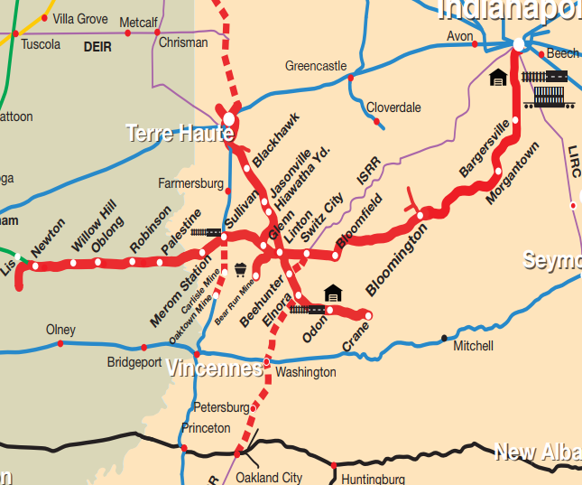
System Map, This is obsolete. See below for a 2019 update.
It is interesting that their route map does not show the complete routes. It seems to focus on it customers in it core area. IRND started in 1986 by buying the IC route between Newton and Indianapolis when ICG management was so aggressively getting rid of everything except their north/south mainline. "INRD has invested more than $200 million of private capital into the railroad, transforming a broken-down railroad into a state-of-the-art, heavy-haul transportation system." (About)

The Trains Magazine has mentioned more than once how progressive the railroad has been. They have been using single-person crews in through trains for a while. They have a deal with CN to run intermodal trains from CN's west coast ports to Indianapolis to provide the least complicated, and I would assume cheapest, route from Asia ports to Indianapolis.

When CN charged a lot for the final 6 miles needed to run coal trains from Indiana mines to the Newton Power Plant, they built a parallel track to avoid CN's charges. (I see from the Google Map that Newton Power Plant is now Anderson Electric.) My 2005 SPV Map shows the former Milw/CTH&SE route from Chicago to Southern Indiana being owned by CP. Sometime since 2005, INRD must have bought that route from CP because they show it on their system map.

I notice that the Louisville & Indianapolis (LIRC) route is also in red on their system map. Perhaps they bought trackage rights. It is a shame that the Milwaukee route does not still go to Bedford and that the Monon route from Bedford to Louisville has also been abandoned. If Class I railroads had not been so quick to tear up track, INRD could have had their own, more direct, route from Chicago to Louisville.

Their operating hub is the Hiawatha Yard, which was Milwaukee's Latta Yard.

The following load shows INRD is willing to think far out of the box (clearence plate) to serve their customers.
John W. Coke posted
Indiana Rail Road transporting dragline coal buckets from the Blackhawk mine to the Bear Run mine.
Update:
Jim Matuska posted
INRD 9008 - 2012 / 2019
A few years ago I read an article that quoted an Indiana Rail Road honcho bragging about using Tier 4 engines. (I researched how they beat the Class I railroads to Tier 4. The answer is that they used Cummins engines that use DEF. ) That engine looks worse than Tier 0.
I noticed the location is in Wisconsin. Whose tracks is this train running on?
An article about INRD receiving a marketing award describes the CN/INRD intermodal service. This new service is growing.

A photo of train SAHW - Indianapolis to Hiawatha Yard - with two SD9043MACs crossing the Shuffle Creek Trestle.

Bob Lalich Flickr 2011 Photo, what route did INRD use to get to BRC to get petroleum coke from KCBX Terminal? (2019 Update: The "Shortlines" link that I added to the top indicates INRD has track rights over CSX's former C&EI route from Terre Haute to Chicago.)

System Map
Richard Koenig posted three photos with the comment:
Special Move—New Lebanon, Indiana
It looks like a special move is taking place this dreary day in the late-70s. This occurred on the Illinois Central Gulf Railroad between Palestine, Illinois, and New Lebanon, Indiana. I believe these large girders were bound for a nearby power plant but have no reason to think this. Does anyone have a recollection of what was going on here?
Three images by Richard Koenig; taken early in 1979.


1

2

3

Jay Tower: CN/EJ&E vs. UP+CSX/C&EI in Chicago Heights

(CRJ, Satellite)
NorthAmericanInterlockings:  1992
Chicago and Northern Indiana Railroad Interlocking Towers (click the marker for the correct information)
26th Street Yard: (Satellite)

Bill Molony posted
The EJ&E - C&EI interlocking tower at Chicago Heights, Illinois - June 6, 1981.
Bill Molony posted again
Bill Molony posted
The Elgin, Joliet & Eastern - Chicago & Eastern Illinois interlocking tower at Chicago Heights, Illinois on June 6th, 1981.
Photograph by Jeff Strombeck.
From the Blackhawk collection.
Michael Steffen: Trenton Dominy Jay Tower. Worked there as a Tower Operator (Telegrapher without a key) for a period of my EJ&E career. It was Jay Tower to the C&EI/MP/UP and Chicago Heights Tower to the J.

Jon Romo posted

Satellite
Flickr has an April 22, 2007 picture posted by Sayre Kos that includes the tower in the southwest quadrant. The EJ&E east/west route is now owned by CN. The C&WI north/south route is now used by UP+CSX+INRD.

Judging from the land scars in the satellite image, there used to be connections in all of the quadrants except the northeast. But looking at a 1938 photo, the only connection was in the tower's quadrant. Buildings had to be torn down to make the southeast quadrant connection that we see today.
1938 Aerial Photo from ILHAP
David M Laz posted
[This is the same photo that is in CRJ.]

John Eagan postedHere is the interlocking board from Jay Tower in Chicago Heights, IL. It is in a private collection awaiting restoration.
Todd Lewis The interlocking from.nb up to eb ej&e, does anything use that connection? I never see any trains take that route to interchange. I used to see the J pull cars from their yard west of the diamond and go to the CHTT yard south of the diamond before but that was years ago.
John Eagan Yes, and UP used to use that connector to get to the e/b GTW at Griffith, but it's been a while since I've seen trains use that track.
Michael Steffen The two larger holes in the board at the top were for the switches that controlled the eastward and westward J train order signals. A red, yellow or green board was shown by the appropriate indicator lights.
Chris Lajcin I remember I was sent out on New Years Eve to retire all T.O. signals from Ivanhoe to Rondout before 12:01 A.M.

Donny Albertson posted
Ever take a shot and have the sun peek out at just the right time? Well this wasn't one of those times, and it's my only EJ&E shot too. A pair of SD38-2's cross the MP at Chicago Heights IL at Jay tower on 26MAR1990.
Mark Llanuza posted
Its 1988 at Chicago Hts tower.

Mark Llanuza posted again
Zaky Joseph When the tracks, locomotives and tower were all the "J".

Mark posted again
Craig Cloud All J towers pistol grip?
Matt Lasayko Craig Cloud Bart tower in Hobart IN had Armstrong levers
Brian Harp Same at Barrington
Richard Weber The tool house for M of W employees has been torn down.
Tom Legner Richard Weber we knew all they wanted was the rail, no buildings, no equipment and NO EMPLOYEES!!! Glad I’m outta there.
John DeWit Woodlock II posted
EJE 657,654 @ Jay Tower-South Chicago Heights,IL 28 MAR 05.
Dennis DeBruler I used Google Earth's timeline feature to establish that
the only connector that existed at this junction was in the southeast quadrant.


John DeWit Woodlock IIJohn and 2 others manage the membership, moderators, settings, and posts for Windy City Rails. That is where this picture is taken. The J was running into the yard just south of the diamond about two blocks or so south,

Jim Valiquet This connection was a connection controlled by the tower and was part of the interlocking back in 1977 .The MP used to use this connection to deliver to the the "J' west yard west of the tower . there was another wye in the south west quadrant that was all hand throws that the "J" used to deliver to the MP yard . I know this because I worked Jay tower off the extra board back then we would have to call the MP yard clerk when a train was going to deliver to the MP and get a track and radio the track number the delivery would be set out on to the "J' crew.
Joe Usselman posted
Jay tower in 2010 at Chicago Heights shortly before it was torn down.
Denis Johnston commented on Joe's posting
Not my shot, I just appreciate the picture. My shop is about a mile from this location.

John DeWit Woodlock II posted
UP 1399,1429 @ Jay Tower-South Chicago Heights,IL 15 AUG 99.
Stan Sienicki posted
JAY Tower Chicago Heights, IL. April 05, 2007 this is from GTW(CN) Train 271, former EJ&E Tower protecting the EJ&E(CN) and C&EI(UP) Soon to be dismantled after I took this image.
Chip Gay One busy junction today

Dennis DeBruler commented on John's posting
 I was shocked to see that the tower was still standing in a street view. Then I remembered to check the capture date: Aug 2009. https://www.facebook.com/.../permalink/232474354026644/...
Eric Berg posted
Northbound C&EI #92 comes by Jay Tower at Chicago Heights on June 10, 1958 with C&EI #1600 and a mixed freight train. The EJ&E operator stands outside the door to inspect. (C&EIHS Photo)

Bob Bruns Flickr posted, but Facebook won't give me a link, a 1982 photo

Elgin Joliet & Eastern 663 at Chicago Heights


EJ&E 663 on an eastbound passing Jay tower on 8/14/1982. Photo by Bob Bruns


Michael Bachmann posted two images.
Michael Steffen The Heights, harmonic rock & roll.
Matt Chambers What year was this?
Michael Bachmann If I had to guess, 93, 94
Richard Weber I was on vacation and got the call. If I remember the coal pile was smoking.
1

2

Junior Hill posted
At Chicago Heights, the J local is facing south on U.P rails and will hit the switch here to deliver interchange to the U.P at their yard here. The J's tracks cross the U.P in the distance where you see J tower. This was a daily occurrence on the J for years, but now the J is gone, the tower is gone, and the U.P's yard here is vacant, with the exception of some stored cars. Jesse Berryhill 2/8/2009
Jimi Krentkowski Great pic! Lots of questions! 1 : what kind of switch was in this photo? ( they removed it to extend the yard lead. The old switch looked like there was no room for the flange. 2: CN doesn’t seem to interchange on Villa Grove sub anymore? Anyone know why? 3: They took out the switches from the CHHT to J tracks East and west of state st in the heights, any reason? Quest 4- CSX sometimes comes off Villa Grove Sub onto J eastward, haven’t seen that move in long time. Anyone know where train originates/ terminates? Thanks !!!
Junior HillJimi Krentkowski Not sure about the switch. I think CN now does all work with the UP at West Chico. The switches at State St in the Heights were removed for the same reason, no more interchange work here, I have many shots of the J working this yard as well. Not sure about that CSX train, I remember seeing coal move off the UP east on the J back in the day. Thanks for the comment.
Denis Johnston My company is located in So. Heights, so I watch this area. Was very busy with new freight cars when Thrall Car was in full production.
[So UP, instead of CSX, dispatches this shared track between Barr Yard and Woodland Junction. There are comments on the post about UP requiring the J crew to do a lot of talking to gain access to their yard.]

Denis Johnston commented on Junior's post
Pretty much same location. Not my photo, Shooter unknown to me.

Junrior commented on his post
Same Job, different day. The J had just delivered an entire train to the UP's yard at S. Heights. The train was cut into 2 tracks to fit in the yard. The conductor can be seen getting ready to grab the marker and head back to J tracks engines light.
This must be the UP interchange yard the above comments are talking about.
Satellite

Jesse B. Hill posted
EJ&E 673 swings off home rails and onto the UP Villa Grove Sub with 25 cars to drop in 2 cuts for the UP/CHTT at S. Chicago Heights, IL,
26th St. Yard. They'll leave out of the UP yard with 20 cars to head back east with to Kirk Yard. Photo Date 2/28/2009. Fast forward to the year 2020 and we'll find this particular interchange practice extinct like dinosaurs, nothing is interchanged between the CN and the UP here today. Also, J Tower seen in the back round has been gone for many-a-year now.
Peter Smith The cars to Markham and the UP comes out of yard center in Dolton and gets them.

Jesse B. Hill posted (same comment)
Craig Cloud Jesse B. Hill did CN remove any interchange tracks by J twr?
Jesse B. Hill Craig Cloud No, there's an occasional train that runs between the 2 lines, it's not too often though.

Jimi Krentkowski posted four photos with the comment: "Looks like the Villa Grove sub is finally installing CWR. They Drop the rails about two years ago. They have 26 street yard filled with maintenance of way. The question I have is the diamonds by the demolished Jay tower. These are the second set of diamonds that have been installed. Anybody know the reason why? Also if you look closely the tracks of the UP barely touch the diamond as it crosses the J. Any information on this diamond would be helpful."
Jim Sank: TJ Cloke Not OWLS in the photos, both ways are high speed Flange Diamonds where you can do diamond speed over them, where OWLS are Limited to 10mph on one side. My place of work has the High speed where we do 40 over them on both side.
Harold J. Krewer: Jim Sank, thanks for explaining this. I knew it couldn't be an OWLS as they are not designed to handle heavy tonnage on the low-speed side and there was no way UP and CSX were going to put up with going 10 MPH over the J.
1

2

3

4


(new window)  I don't like the video style of watching an empty scene just because you can here the horn blowing. But I did like the old green hoppers starting at 2:47. At first I assumed they were BN cars. Then I saw the red circle of the C&NW herald. The INRD reporting marks indicate they are now owned by Indiana Rail Road.


See Railroad Hub for a couple of contemporary trains going through Jay Junction.