These are notes that I am writing to help me learn our industrial history. They are my best understanding, but that does not mean they are a correct understanding.
Thursday, March 16, 2017
Flood of 2019: 1860s+1934 Lock and Dam #15, Rock Island, IL on Mississippi River
The dam L&D was constructed between 1931-34. [Tom Sharp comment on a post]
Retro Quad Cities posted A 1931 artist's concept of the $5,000,000 lock and dam project, later to be known as Lock and Dam 15. It would be the largest roller dam in the world and also the only dam on the Mississippi River that is not perpendicular to the river. Brad Wooldridge: 87 million in today’s dollars. Dana Olson shared Dave Harrington: Prior to dams 14 and 15 canals provided the lift/drop. The Laclaire canal and aux lock 14 still functions. Remnants of the Moline/Rock Island canal are still visible. Most of the two canal walls are submerged and have eaten many pleasure boat drives over the years. Adam Rooster Hensley: I see one big problem with this drawing.... there's no way that tow is fitting in lock 15.
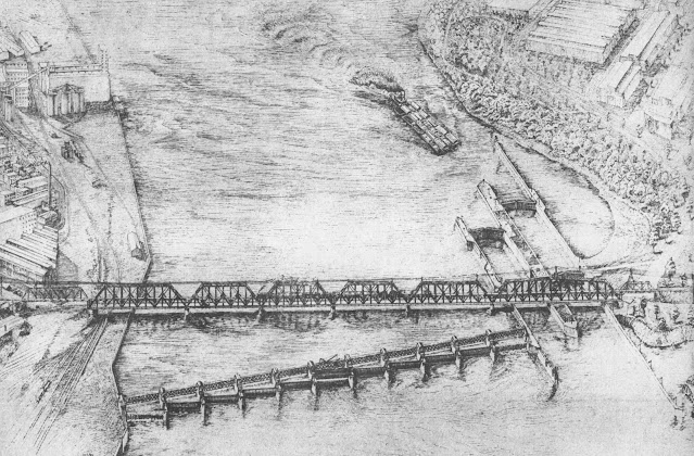
This provides a nice overview of the bridge and the L&D.
The auxiliary lock at Locks and Dam 15 between Davenport, Iowa, and Rock Island, Illinois, will be open for the upcoming holiday weekend [2026]!
The lock will be open with dedicated staffing 12pm - 12am on Friday, July 3 in support of the Red, White and Boom Fireworks, and 10am-10pm on Saturday, July 4.
While the auxiliary lock at LD15 will be open for the holiday weekend, the auxiliary lock at Locks and Dam 14 in Pleasant Valley, Iowa, will remain closed.
Please remember to be safe and wear your life jacket when in, on or around the water!
USACE, Rock Island District posted two photos with the comment: "Today's 'Then & Now' takes us back to 1966. The clocktower building on the west end of the Rock Island Arsenal continues to stand strong where it has stood since 1932 and houses the Rock Island District headquarters."
1
2
Iowa Road Trip posted The largest roller dam in the world is Lock and Dam 15, which spans the Mississippi River between Rock Island, Illinois, and Davenport, Iowa. It measures 1,203 feet [367m] long and consists of 11 roller gates. It's the only dam on the Mississippi River entirely made of roller gates. Brian Abeling / Iowa Road Trip
John Meyer: Yeah and there are some Catfish that hang out by those rollers that might possibly be the biggest in the world as well.
[Some comments implied "man-eating catfish." But those comments were refuted.]
Iowa Road Trip posted again with the same description except he added: "Rumor is that the catfish under this dam are large enough to eat a human being."
Nathaniel David Brockway: Know an underwater welder that worked on lock 9. Said you couldn’t get your arms around them. He said as long as his arc was lit they would stay back but would close the distance in the dark.
[There are more comments about the size of the fish.]
1 of 23 photos posted by Raw Images Art & Photography The Government Bridge at Lock and Dam 15 along the Mississippi River. Soon the navigation channel will be open for barges. [The bridge is out-of-frame to the right in this photo.]
This Where am I Wednesday I was inside the Clock Tower on the Rock Island Arsenal. The clock tower was the first building on the arsenal - known as Storehouse A. It had become obsolete, however the US Army Corps of Engineers took over the building in the 1930s when they were building the lock and dams. The Clock Tower has been home to the Rock Island District of the US Army Corps of Engineers ever since.
The cornerstone was laid on April 12, 1864. The building was built with stone from LeClaire, Iowa. The tower was built in the summer and fall of 1867 and rises 117 feet. The clock was installed in 1868 and is a Hotchkiss clock. It was wound by hand weekly and took 2 men twenty minutes to do. The clock was later switched to electric winding in the 50s. The craftsmanship of the clock and carpentry of the building is remarkable. I went on an eagle tour this past Sunday. They do free eagle tours every year. I highly recommend all of the Rock Island Arsenal tours as well as a trip to the Rock Island Arsenal Museum.
USACE, Rock Island District posted two photos with the comment: "Today's 'Then & Now' takes us back to 1933 and shows construction of the dam at Locks & Dam 15 in Rock Island, Illinois, nearing completion. Construction of the dam started in 1931 and wrapped up a few months after this photo was taken, in 1934. These photos show just a small section of the 1,203-foot-long movable roller dam, which is the largest roller dam in the world!"
[It remained the largest because roller gates soom became obsolete. The USACE figured out how to make long Tainter gates.]
1
2
Bridges Now and Then posted Lock and Dam Number 15, Davenport, Iowa, and Rock Island, Illinois, October 26, 1932. (Historic Bridges)
Retro Quad Cities posted 1932 Lock and Dam 15 earlier stages of construction
Retro Quad Cities posted 1933 July construction of lock and dam 15
These photographs were taken during the construction of lock and dam No. 15, although the roller dam does not appear to have been started yet.
The top photo shows equipment owned by S. A. Healy. Stephen A. Healy was the contractor for the erection of the dam and Davenport intercepting sewer and sea wall.
On the night of March 22, 1932, a large part of the coffer dam built by the Merritt, Chapman & Whitney Corp., for the building of the auxiliary lock, was torn away by the large quantity of floating ice in the Mississippi river. It was believed that the floating ice filled the coffer dam and pushed the 150-feet section away. Engineers estimated the damage would delay construction about a week.
Fans of Rock Island Lines posted No words needed, in case you're new here or it's your first viewing of my material. The government bridge between Rock island IL to Davenport Ia. 4th span, roller dam going in and locks being poured. [We are looking downstream at part of the lock being constructed. The dam is out-of-frame to the right.]
This photograph shows some of the complexity of construction necessary in building Lock No. 15.
On March 31, 1932, Albert Norman, a 37-year-old employee of Merritt-Chapman and Whitney, builders of the new locks, was drowned when the motorboat he was in capsized midstream while at work on the government locks project. He was considered an expert swimmer, but the weight of his heavy clothing probably caused him to become exhausted before he could reach a nearby coffer dam upstream that he was swimming to reach. His body was found a month later at the foot of Myrtle Street on April 25th. A second worker, James E. Curtis, was also thrown overboard, but managed to swim with the down current and was rescued about 400 yards from the accident. The men were using the boat to tow an empty rock barge downstream when the accident occurred. The motorboat was caught in a cross current beneath the bridge, while the barge continued in the straight current, which capsized the boat.
Mr. Norman was born in Catalina Trinity Bay, Newfoundland, in June of 1895, and came to Salem, Massachusetts, as a boy to work in the shoe factories, later becoming a shop foreman. In June of 1931 he came to Rock Island to enter the employ of Merritt-Chapman and Whitney. His brother met a similar fate 18 years earlier.
Predominant above the Davenport skyline in the background of this photograph is the pedimented temple and three-story clock tower that surmounted the Davenport Bank & Trust Company building on the southwest corner of Third and Main streets. The building, originally the American Commercial & Savings Bank, was completed and ready for occupancy on June 1, 1928.
This photograph shows work commencing on the shorter auxiliary lock at Lock and Dam No. 15. The main lock was completed and filled on March 1, 1932. It is 600 feet long and 110 feet wide. The main lock was used for river traffic during the summer while the auxiliary lock was being erected to the north. The auxiliary lock is 360 feet long and 110 feet wide. The auxiliary lock was completed and flooding of it commenced on November 4, 1932.
Davenport is shown in this photo in the upper left with the Western Flour Mill in view, the makers of Goldrim flour. At that time, a 49-pound sack cost as little as $1.14.
Joel Wise posted My first shift on my own as a swing-bridge operator after completing the apprenticeship (and having a spot open up for promotion). I’m a fully certified bridge troll! And the view? I think it’s pretty cool. [He is on the Government Bridge.]
Obviously, this was an emergency repair. Note how high the downstream part of the river is. You can see the prop wash behind the towboat holding the barge in place against the current. They must have the upstream gates open, which is a big surprise. Also, the road was closed during repairs because the bridge span had to be open to make room for the barge.
So, for now, I'll summarize from memory. It was one of the first dams built by the Army Corps of Engineers for the 9-foot channel project for the Mississippi River. At the time, rolling gates were the known technology for big gates, so that is what this dam uses. Since then, the corps has developed the Tainter gate for use in big river dams. Some of the Mississippi dams are hybirds where about four of the gates are still rolling gates. Newer dams use just Tainter gates.
Quad Cities Buildings / Landmarks / History posted
Quad Cities Buildings / Landmarks / History posted
Title
Construction Lock and Dam 15
Date Original
August 11, 1931
Repository
Putnam Museum and Science Center, 1717 West 12th Street, Davenport, Iowa 52804
construction site with rail carts, tracks, equipment, and workers, also Government Bridge
Location Depicted
Rock Island, Rock Island County, IL
Subject
Photographic prints
Davenport (Iowa)
Mississippi River--Locks and Dams--Lock and Dam 15
Construction equipment
Construction workers
Railroad tracks
Government Bridge (Rock Island, Ill.-Davenport, Iowa)
Rock Island (Ill. : Island)
Dam construction
Ordering Information
Contact Putnam Museum Collections Dept. (563) 324-1054
Image Number
Dams27
Repository
Putnam Museum and Science Center, 1717 West 12th Street, Davenport, Iowa 52804
Repository Collection
Photographic Collection
Object Description
1 photograph, 8" x 10" B & W
Digital Reproduction Information
Digital image captured using Microtek ScanMaker 9600XL with transparent media adapter. TIFF file created from a photograph scanned at 8-bit grayscale 1200 ppi. The master scan is untouched, but this display image was enhanced by adjusting the input level of the shadows from 0 to 35 and highlights from 255 to 241 using Adobe PhotoShop 7.0.
USACE, Rock Island District posted Today's #FlashbackFriday takes us back to August of 1933 and the second day that Locks and Dam 15 in Rock Island, Illinois, was in operation! Here you can see a Naval Reserves boat locking through with several onlookers taking in the newest engineering marvel by the Corps, the lock system on the Mississippi River.
Brian Johnson: I believe that is the sidewheel excursion boat the J.S. De Luxe operated by Streckfus Steamers.
John Vize: And now these 600 foot locks are antiquated. [1200' is the new standard.]
Note the Government Bridge goes over the lock structures. It carries a road on the lower deck and IAIS/Rock Island on the upper deck.
There is a webcam for these locks. (2019 Update: a webcam link that works) In fact, that looks like the source of the time lapse video. There were other webcams of other views. Some views designed for bird (eagle) watchers. But I can't find them right now.
1 of 3 photos posted by Jan Danielsen Davenport, Iowa near lock and dam 15. 7-3-26. Those men fish on the ledge often. 🙃
Karl Knudsen: Pelicans have devastated fishing.
Bill Versluys: Karl Knudsen Yes they have.
There should be an open season on them. I've watched 40 to 50 of them at one time and they eat till they can't hold anymore. The dumass DNR is always pushing to stop invasive species, what the heck do they think pelicans are? They don't belong here. Decades ago you never seen even one. Now they follow the spring thaw a the way up the river.
Eric Freuler commented on Jan's post There's fish down there sometimes.
Flood of 2019:
Screenshot @ -:043
Elle Kay
I have never seen a train go through water like this. This is downtown Davenport, IA. I was up in the sky bridge checking out the Mississippi River flooding.
[She happened to catch the gates of the dam rolled all the way up.]
Webcam accessed 3/26/2019
[Note the river level below the lock is the same as above the lock. At least the water is not in the machinery yet.]
I can't believe I happened to catch the bridge with some engines on it. So while I worked on the adding the above info, I reloaded the webcam page to get fresh photos of the train crossing. The train goes real slow. Several minutes went by before I could catch an image with the train gone. I thought the image used to update every 30 seconds. It seemed a lot longer than that now. In fact, I gave up waiting. I don't think I was getting multiple views of tank cars going by because each sample had the same alignment of the tank car ends with the bridge's truss members.
After a record breaking 92 consecutive days (the old record was 37 days set in 2001), the roller dams at Locks and Dam 15 in Rock Island, Illinois, were finally lowered back into the water over the weekend! The roller dams help keep pool levels steady to maintain a nine-foot navigational channel for commercial barge traffic. #2019FloodFight
Jan Danielsen posted Lock and dam 15 and along the river Davenport, Iowa. Pool 16.
David Sebben posted several photos of the Flood of 2019 with the comment: "Today's flood photos from Davenport, Iowa. Since I work just 2 blocks from the river, I ventured down at lunchtime to shoot a few. I can only imagine how much worse it was many, many years ago when there used to be quite a few buildings on the river side of River Drive. Flood level was at 20.6 feet today." These are some of the views of the dam and locks.
a
[The river is near the top of the lock wall under the bridge.]
b
c
d
e
Jan Danielsen posted
The river isn't supposed to be past the fence. AND it won't be one of these days. Davenport, Iowa lock and dam 15.
Adding insult injury: the record flooding of the Mississippi River has created a supply chain problem in our nation's bread basket. Contessa Brewer reports from Rock Island, IL
USACE Rock Island District posted two photos with the comment: "When people think about the main use of locks on the river, they think of the navigation industry, but that's not their only use. Our locks are used for recreational traffic as well and this weekend will be a perfect example of that when Floatzilla passes through Locks and Dam 15 in Rock Island, Illinois! Head over to the Mississippi River Visitor Center on the Rock Island Arsenal on Saturday to get a great view of the largest paddle event on the Mississippi River! The Visitor Center will open at 9 a.m. and paddlers will be passing though the locks throughout the morning and early afternoon hours."
U.S. Coast Guard Auxiliary - Paddlecraft Safety Division: We'll be there. 🙂
1
2
Art Winstein posted there photos with the comment: "Lock 15A being repaired."
1
2
3
Joel Wise posted Daniel T Martin making their entrance northbound into Lock 15 this morning.
Seven of the 75 photos posted by Raw Images Art & Photography with the comment: "Next up on the list of my favorite shoots this year is Lock and Dam 15 - dewatered. I went to the welcome center overlook multiple times and my nephew who works for the US Army Corp of Engineers took me down to the bottom of the lock. The pictures are a combination of several different dates so they may not come through in a specific order. There are some pictures in the tunnels underneath the locks too. So cool. Can't say how much I love the US Army Corps of Engineers. Huge shout out to them for keeping navigation open and all the countless things they do that we have no idea."
Tammy Mutka shared with the comment: "Last winter, lock and dam 15 on the Mississippi River, was dewatered for maintenance. These are photos taken from the observation deck and below from the floor of the dewatered lock. One of my favorite shoots last year! Thank you USACE. Thank you tow boaters. Merry Christmas 🎄"
Obviously, they get equipment and material in the lock by floating these barges in before they pump out the water.
a
A closeup
b
Looking the other way, we see the ramp at the end of a barge that they use to drive the equipment off the barge. We can also see, near the bottom of the lock, the holes through which the water flows to fill and empty the lock. This is also a nice view of the IAIS/Rock Island Bridge.
c
This is the business end of the excavator attachment that is used to removed concrete.
d
e
Note the holes along the lower right side of this tunnel. Those are the holes that we saw in the lock chamber. This tunnel is what the water flows through.
f
A view with people to provide scale.
g The author commented: "This is under the lock. You could drive a semi down there"
1 of 60 photos posted by Raw Images Art & Photography For those of you who know me - you know I love those red cranes. This one is a Seatrax that is currently docked at Lock and Dam 15. It belongs to the US Army Corp of Engineers and is a floating crane called the Quad Cities. I was told they just finished working on the up river gate. This crane is a beast. If you like cranes, you will love these photos. Shout out to the US Army Corps of Engineers Rock Island District. Xzantronos Aldreas: I got to take a Tour of it, I was on the M/V Gladys Ford that brought it to it's first job at Leland Bowman locks in the ICW. Here is a fun fact. It has an automatic ballast system that keeps that big girl level while in operation. Tammy Mutka shared
Brandon Philips provided four photos with the comment: "Joel Wise operating the Bridge so the LST 325 can lock though." [I changed the order to put them in chronological sequence.
USACE, Rock Island District posted four photos with the comment: "This week, Rock Island District dredging crews were working below the lock at Locks and Dam 15 in Rock Island, Illinois, removing sediment from the navigation channel. Dredging is an integral part of yearly channel maintenance to ensure the navigation industry can continue moving up and down the river. District crews can remove up to five barges of sediment a day and this year plans to dredge 750,000 cubic yards of material."
Melissa Cook: Where do they put 750,000 cubic yards of sediment?
U.S. Army Corps of Engineers, Rock Island District: Melissa Cook the sediment is placed in areas based on our Dredged Material Management Program (DMMP) which evaluates and identifies preferred dredged material placement sites. You can read more about the program here:
USACE, Rock Island District posted four photos with the comment:
On Saturday, Locks and Dam 15 in Rock Island, Illinois, once again welcomed hundreds of paddlers as part of the "Floatzilla" event held annually in the #QuadCities area. With the help of the lock employees, rangers, and the Rock Island Arsenal Fire & Emergency Service, #paddlers made it into and out of the lock chamber with no issues and continued on their way during this incredibly unique event!
1
2
3
4
We get a new view of the "Clock Tower Building" from which the photo at the top of these notes were taken.
1 of 5 photos posted by Jan Danielsen The river is rising. Lock and dam 15 area from Davenport, Iowa. 3-30-26. Latest report 10.02' this afternoon. Flood stage 15'. NOT flooding at this time.
It appears that Jan took her photos from these steps.


No comments:
Post a Comment