The building on the left in this photo is what motivated this research.
 |
| MWRD posted A view to the west of 18th Street near the South Branch of the Chicago River on November 12, 1902. |
 |
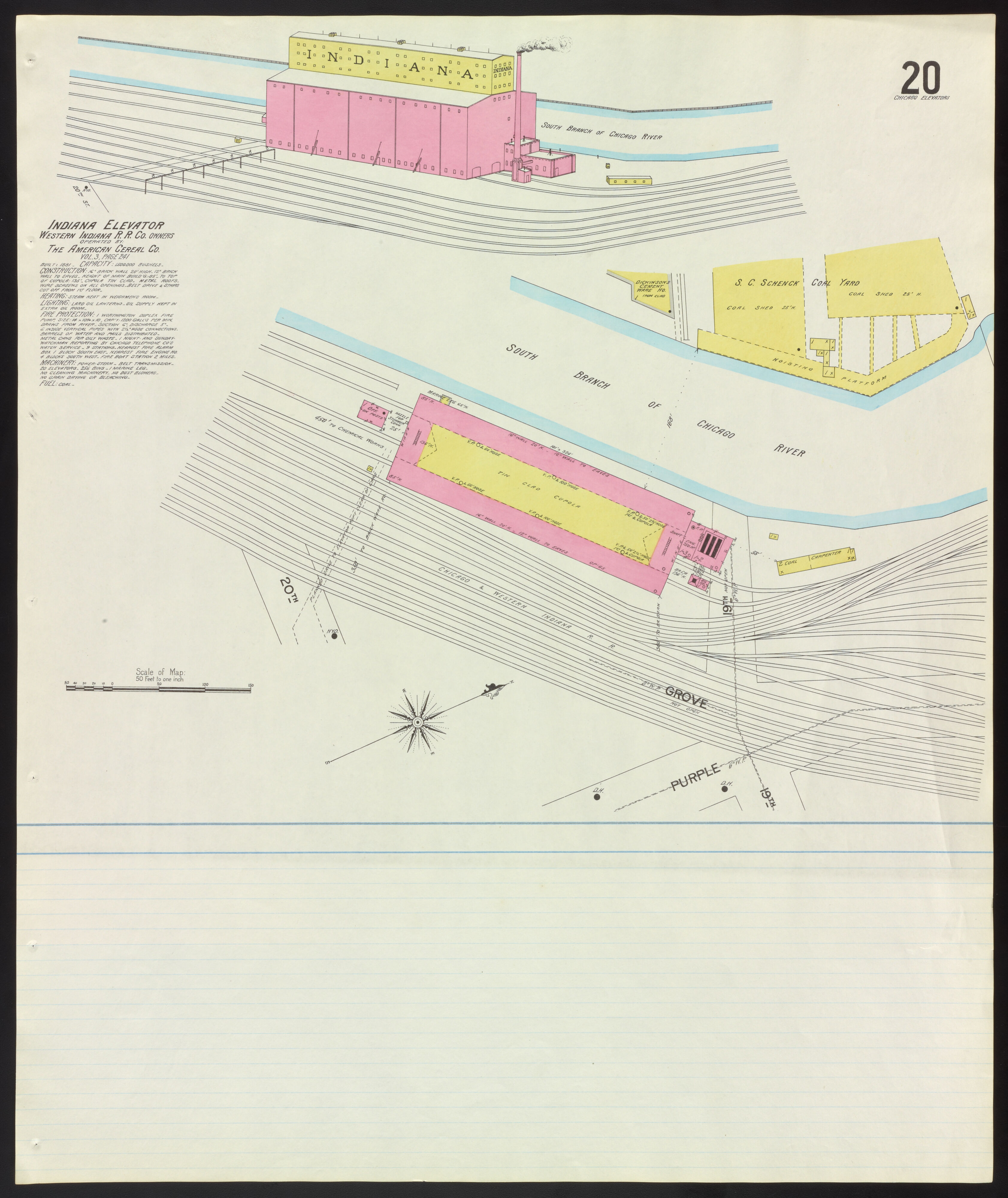
| Dennis DeBruler commented on MWRD's post The buildings north of 18th Street were the Schoenhofen Brewery. According to this 1901 Sanborn Map, the grain elevator on the left was the Indiana Elevator. I think the truss span is over the C&WI tracks. |
 |
| Dennis DeBruler commented on MWRD's post This photo uploaded by Paul Jervert confirms that the photographer was standing in the west end of the truss span over the Santa Fe tracks looking at the truss span over the C&WI tracks. The grain elevator would have been between the train and river and would have obstructed the view of the C&WI truss. This area is now the Ping Tom Memorial Park. |
 |
| Sanborn fire insurance map provided courtesy of the Map Library at the University of Illinois at Urbana-Champaign. https://images.digital.library.illinois.edu/iiif/2/c5a350f0-c457-0133-1d17-0050569601ca-b/full/3365,/0/color.jpg via 1901 Grain Elevators |
This elevator would have been served by the Chicago & Western Indiana Railroad.
 |
| Digitally Zoomed |
Dennis DeBruler posted the MWRD photo with the additional graphic.
 |
| Satellite The red arrow shows where the photographer was standing and which direction he was facing. |
In this 1938 aerial, the Indiana Elevator has been replaced by more tracks, but the two truss bridges are still standing.
 |
| 1938 Aerial Photo from ILHAP |
The elevator is on the left side of this photo.
 |
| The last photo from eight photos of elevating the tracks northeast of here is worth copying. |
The elevator is on the right side of this photo.
 |
| Al Krasauskas posted Photographic view of the former Railroad Swing Bridge over the South Branch of the Chicago River. Originally built by P. F. W. & C. R. R. (Pittsburgh, Fort Wayne and Chicago Rail Road). I believe the view is actually northeast, towards downtown Chicago. Photograph is dated 8-7-09. Paul Webb shared |
 |
| Digitally Zoomed to Photo Resolution The "Quaker Wheat Berries" and "Quaker Corn Meal" signs on the end of the elevator show why the full name of this elevator is "Indiana, The American Cereal Co.". |
 |
| Al commented on his post Robinson's Map of Chicago, 1886, shows that the tall structure at right was the Indiana Elevator grain warehouse and that lumber sheds were across the river, left in photo. Elevated 18th Street bridge and roadway are visible in the background. |
No comments:
Post a Comment