While looking for some wood grain elevators in Harvey, ND, I noticed a lake with a straight edge. Since that is the signature of a dam, I zoomed in on the straight edge. The dam is an embankment with a highway going over the top. What struck me as strange, and why this dam is of note, is that I could not find an emergency spillway for it.
 |
| Satellite |
Its main purpose is water supply. But the results from a Google search show that the reservoir is also used for fishing. Since the dam was built in 1920 and the Soo Line Railroad helped design it [NationalDams], the water supply was probably originally for steam locomotives as well as the town.
When I zoomed in on the inlet structure for the culvert, I realized that it was also the emergency spillway. A shadow on the north side indicates that the water level is below the walls of the open inlet.
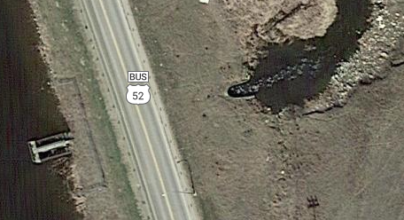 |
| Satellite |
A closer look at the inlet structure shows that the normal flow through the conduit is controlled by a sluice gate. The "walls" would be the emergency spillway.
 |
| Street View |
Harvey used to be a division point for the SOO Railroad, so I checked out a topo map to see if it used to have a roundhouse. (It did.) That is when I noticed that the Sheyenne River has dug a significant ravine in the land. And the water would have to rise about 1575-1543=32 feet to breech the dam.
 |
| 1951 Harvey Quad @ 1:24,000 |
Actually, I think 1543 must be the bottom of the culvert rather than the top of the spillway level because the height is listed as 31' from the lowest part of the original streambed to the crest of the dam. [NationalDams] The street views did not look like the crest was 31' above the inlet walls. The normal storage is 2,700 acre-feet and the max storage is 7,646. Looking at the watermarks on the inlet structure, the water has gotten just a couple of feet above the spillway walls.
The map shows the original dam ... with a concrete spillway. In the early 1960's the highway was rebuilt, doubling as a new dam with the reservoir level raised about seven feet to an approximate level of 1550 feet above sea-level. The primary reason for raising the level of the reservoir was to help ensure fish stocked in the reservoir would survive through the long winters.
ReplyDelete