Sunday, March 7, 2021

1888 Jackson Boulevard Swing Bridge over the South Branch

(3D Satellite, it has been replaced by the 1916 trunnion bridge)

A Joseph Strauss designed trunnion bridge replaced this one in 1916.

Pavel Bv posted
Former Jackson Street Swing Bridge, 1892. “Union Depot” rail yard on the front left.

MWRD posted
MWRD posted
The original Jackson Blvd. bridge from the west end looking east in 1914.
MWRD posted again

MWRD posted
A view to the south from the Adams Street bridge on May 10, 1904, showing the Pennsylvania Railroad tracks and warehouse on the west side of the South Branch of the Chicago River, with the Jackson Street and Metropolitan West Side elevated railroad bridges visible in the background. The inlet to the bypass tunnel, which had been built by the Sanitary District (now MWRD) to accommodate increased flow of water through the Chicago River to the Chicago Sanitary and Ship Canal, is at left below the railing. 

Patrick McNamara shared

MWRD posted
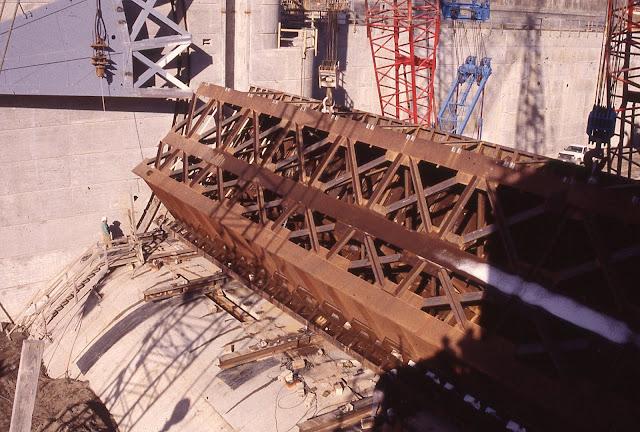
Historical Photo of the Week: The cofferdam on the west side of the South Branch of the ‪#‎Chicago‬ River during construction of the Jackson Blvd. bridge on April 2, 1914, viewed from the south side of the swing bridge that was being replaced.
MWRD posted
The cofferdam on the west side of the South Branch of the Chicago River during construction of the Jackson Boulevard Bridge in Chicago, Illinois, on April 2, 1914. The MWRD built the bascule bridge to replace the previous swing bridge. It was completed in late 1915 and was opened to traffic in January 1916.

MWRD posted
A view from the Jackson Street bridge looking south towards Van Buren on September 5, 1903, showing an area adjacent to and above the bypass channel on the South Branch of the Chicago River. The Sanitary District (now MWRD) developed a plan in 1895 to increase the capacity of the South Branch in order to convey necessary flow of water for the Chicago Sanitary and Ship Canal. The MWRD deepened and widened the waterway by dredging and replacing docks and bridges, and where bridge replacement was not feasible (roughly between Van Buren and Adams) the MWRD built a by-pass channel. Construction of the bypass channel began in 1898 and it opened in 1900. It was removed beginning in 1911 after adjoining property was acquired, allowing for widening of the river in the area.

Friday, March 5, 2021

1968 Belleville Locks, Dam and 1999 42mw Hydropower on Ohio River

(Satellite)

I had complained that the Huntington District doesn't include aerial photos. But when I accessed their page in Mar 2022, they had this photo. This information is from their previous version of their Belleville page:
The damming height is 32' above the sills, and the normal lift is 22'. The locks are 1,200' and 600' x 110'. The eight Tainter gates are 110' wide and the "clearance above maximum high water when fully raised [is] approximately 5ft."
USACE
Replaced locks and dams Nos. 17, 18, 19 and 20 on Ohio River, Dam No. 1 on Little Kanawha River and Dam No. 1 on Muskingum River

We Work the Waterways posted
Todd Hanson caught this unique photo at Belleville Locks & Dam at mile 203 on the Ohio River.
The 50th annual Ohio River Sternwheel Festival Festival Regatta will be held next weekend in the river city of Marietta, Ohio. 
Here we see Amherst Madison’s M/V LUCEDALE towing northbound the Sternwheelers HENNY COOK, ROY C, KANAWHA, and NEMACOLIN, plus a couple of deck flats that will serve as the entertainment stage at this famous event.
A good time will definitely be had by all!
Be sure to stop by and visit We Work the Waterways at our booth during the festival. We’d love to see you! Check out the full festival schedule here: 

AMP
[I believe this photo is of the Belleville Dam. AMP added the 42 MW run-of-the-river hydroelectric power plant to this dam.]

This is the third example I've seen of the Ohio River running high during the first week of March, 2021. The first example was a photo showing the downstream pool of a Byrd Lock that was about as high as the upstream pool. The second example was a video of a tow going under some Cincinnati bridges with a high river. This example is the M/V Edith Tripp becoming disabled because its single propeller got jammed by a log.
Dan Kemper posted
Edith Tripp, on the left and Mrs Hatcher passing under the Ravenswood bridge about 530 pm 3,/3/21. One of them broke loose upriver and was unmanned. It was caught and was being steered downriver. I think I have seen Mrs Hatcher moored at a sand and gravel business rt side descending , just below the Belleville lock.
Carl Reese: The boat was shoving out of Belleville Lock N/B lost power and went through the dam. They said the crew got off in a skiff with no motor and floated down in the Chamber and got off on a lock wall. We made crew change at Belleville this Morning on the Mary Lucy Lane. They locked up behind the Mary Lucy. My partner that relieved me called and told me that it happened. Glad everyone is ok.
Jamie Sunderland: Carl Reese talked to man over the locks this morning. The boat made it about 1/4 mile above the locks. Got something in the wheel and smoked the clutch. They then started getting folks to the banks. Boat hit the piers and broke loose. Boat went under roller and barge stayed stuck. They retrieved the other barge this morning. As they lowered water levels the barge shifted and flushed through also.
Dan Kemper: Carl Reese Crew was on the ball to get off that fast . Amazing.
Bud Osbourne: Jamie Sunderland The heavy drift, above the lock, is what got the Jon S. Strong stalled out right above the dam, in 2005. I suspect it was heavy drift accumulation that caused this one, also. Just glad to learn that everyone is OK. Could have been really horrible, very easily.]
Joe Engle: Mrs. Hatcher used to be Dale Taylor. Works the valley fleet at mile 230.
[Note that the gates were tainter, not roller. The trainter has 5' clearance above maximum high water. The hydrologic diagram below shows the maximum is 43' and the river was around 34' at the time of the allision. So it had 5+(43-34) = 14' of clearance. The M/V Edith Tripp is 34' tall with an 8' draft. So for a 26' boat to go through a 14' hole, the boat would have been shoved over pretty far as it went under the gate. It is amazing the radar mast is just bent rather than broken off.]

"While going through the Belleville Lock, a log became entangled in the single prop causing loss of power to the vessel." (So Bud Osbourne's theory of drift causing the accident was correct.) M/V Mrs Hatcher was able to catch up with the Edit Tripp around Portland, OH. In the photo above, it is returning the captured Edit Tripp to its base of operation, Valley Stone, in Millwood, WV. Later, Mrs Hatcher made another trip to retrieve the barge after it came loose from the dam. This article says Edith Tripp went through the lock instead of a gate. But that does not explain how the radar mast got bent. (The article's use of the name Miss Hatcher is incorrect. The Facebook comments are correct concerning Mrs Hatcher.) [MeigsIndyPress] (I didn't know that some towboats had just one screw. I wonder how they move the front end of a tow sideways with just one screw.)

The river was running high on Mar 3, 2021.
Hydrology

WTAP Screenshot @ 0:30
[Note that the barge is behind the middle two gates. There are closeups in the video.]

I'm updating the hydrology information so that I can compare the prediction to what actually happened.

Dan Kemper commented on his post
 Belleville lock under construction , about 1968

Dan Kemper commented on his post
I did have a pic of survey I did that still showed the crane rails from construction.

Jamie Sunderland commented on Dan's post
Here is the rails still in place from the crane.
Dan Kemper: That is a one heck of an imaging device. Amazing !!!

At first, I was trying to figure out why the water would be so turbulent in a lock. And then I realized that I was looking at an ice flow in the lock.
David Webster, Jan 2018

Another view of Mrs Hatcher towing Edit Tripp. The bridge in the background is at Ravenswood, WV, 
CR Neal commented on Dan Kemper's post
Glad to see I didn't photobomb your shot with my drone Dan Kemper.

Belleville is where the 8-man crew escaped from Edith Tripp, Portland is where the towboat was caught, Ravenswood is the location of the two photos, and the red dot is Millwood where the towboat was secured by the harbor towboat Mrs Hatcher.
Road Map

Facebook Reel

Thursday, March 4, 2021

An Overview of Cincinnati's Ohio River Bridges

Looking upriver
LC-DIG-highsm- 42059
Credit line: Photographs in the Carol M. Highsmith Archive, Library of Congress, Prints and Photographs Division.
Carol M. Highsmith's photographs are in the public domain.

Looking upriver starting with the CSX Bridge
Beauty of America posted
The Cincinnati And Northern Kentucky Riverfront.
Both sides of our Ohio riverfront are ridiculously awesome—use all four of our beautiful bridges to walk, run, scooter, ride or bike between Cincinnati and Northern Kentucky to experience all the exciting dining, shopping & attractions! Both sides also offer amazing views, although we might be a bit partial to the spectacular views of the Cincinnati skyline you get from the banks of the Ohio river here in Northern Kentucky! Check out the list of Cincinnati and Northern Kentucky riverfront attractions, museums, parks, and restaurants.
Lloyd Scott Hardin shared
 
Ikbal Hossain posted
Chinchinati, Ohio
[The comments contain two more photos with this view. It is a common flight pattern for airplanes.]

Looking downriver
3D Satellite

This post is what motivated me to look at the collection of bridges.
Screenshot from a time-lapse video of a tow going downriver with 53' on the gauge

The same day I saw this video of a tow at Cincinnati on a high river, I had seen a photo of a tow in a Byrd lock that showed the river was high. Someone had mentioned that the river at Cincinnati was 54' and rising so I captured the hydrology data.
Time-lapse video going downriver. Unfortunately, he didn't turn his phone to a landscape orientation.

We Work the Waterways posted eight photos with the comment:
Some really cool aerial shots of Greater Cincinnati and Northern Kentucky. The Ohio River and Licking River, the bridges, riverfront, and surrounding area are shown. 
As We Work the Waterways Director Errin Howard says “There’s no place like Home!” Well, Dorothy in “The Wizard of Oz” was the first to say it, but it’s still rings true today!
1

2

3

4

5

6

7

8

Going downstream starting at the I-471 bridge.
Facebook Reel


Wednesday, March 3, 2021

1985 I-471 Daniel Carter Beard (Big Mac) Bridge over Ohio River at Cincinnati, OH

(Bridge Hunter; B&TSatellite)

The official name is the Daniel Carter Beard Bridge, but Bridge Hunter indicates the popular name is the Big Mac Bridge. "Constructed started 1971; opened to limited traffic 1977; dedicated 1981; entire I-471 project completed 1985." The longest span is 757.6' [Bridge Hunter] When it takes almost a decade to build a bridge, I wonder what the cost overrun was.

LC-DIG-highsm-41940
Credit line: Photographs in the Carol M. Highsmith Archive, Library of Congress, Prints and Photographs Division.
Carol M. Highsmith's photographs are in the public domain.

LC-DIG-highsm-42067
Credit line: Photographs in the Carol M. Highsmith Archive, Library of Congress, Prints and Photographs Division.
Carol M. Highsmith's photographs are in the public domain.

Fortunately, the street view car went on the other side of the flood gate.
Street View

Bridges & Tunnels with Sherman Cahal posted
I never tired of this view of the Daniel Carter Beard Bridge from the Mt. Adams neighborhood of Cincinnati, Ohio. The crossing carries Interstate 471 over the Ohio River between Cincinnati and Newport, Kentucky. Check out more photos and history of this unique bridge at http://bridgestunnels.com/loc.../daniel-carter-beard-bridge/

LC-DIG-highsm-42010
Credit line: West Virginia Collection within the Carol M. Highsmith Archive, Library of Congress, Prints and Photographs Division.
Carol M. Highsmith's photographs are in the public domain.

Tuesday, March 2, 2021

Winfield Locks, Dam and 14.76 MW Powerhouse on Kanawha River

(Satellite)

I never heard of the Kanawha River until I saw Connie's post below. But it is big enough to not only have a waterway but to have some non-trivial truss bridges over it. I'll save the bridges for another day.

I wonder why this dam was originally built with two rather small locks. The tainter gate between the standard waterway lock and the two smaller locks is interesting. We can see from Connie's post that the main part of the dam uses roller gates. The original locks and dam were built in the 1930s with a cost of $6m. The new lock and gate bay were built in the 1980s and 90s with a cost of $277m. So this dam illustrates the evolution of gate technology from rollers to tainters.
The damming height is 28'. The powerhouse has a capacity of 14.76 MW. "New Main lock is 110' wide by 800' long with miter gates. Twin auxiliary locks each of which are 56' wide by 360' long, with miter gates." [USACE]

Satellite

It appears that they have a broken gate and that allows us to see how much the other gates have been raised.
Connie Bays posted
Winfield Locks and Dam, WV
Christian Townsend: Looks like the river is starting to run

Unfortunately, Lock and Dam #25 on the Mississippi River is also known as Winfield Lock and Dam. I finally found some search keywords to give me results for this dam.
Winfield Lock and dam is one of the essential navigation projects on the Kanawha River, used primarily for the shipment of coal and chemicals for the large industrial complex of Charleston. There are 5 recreation areas at the lock site, visitors center, overlook, observation areas, several nature/wildlife habitat ponds and over 1 1/2 miles of fishing acess. Recreation facilities are located in the pool area.
I had noticed this photo in today's, 3/2/2021, Chicago Tribune.
Chicago Tribune

So I checked out the hydrological data. The level of the river more than doubled in a little over 24 hours! This is an illustration of the dangers of rivers in mountain valleys.
water.weather.gov

wvncrails
 "A very swollen Kanawha River below the Winfield Locks. Some mighty big catfish in these waters and the tail waters of the dam along with the sandy river bottom create ideal habitat. Dan Robie 2011"

We Work the Waterways posted two photos with the comment:
Gary Wendell  Photography has provided us with great shots of the Winfield Locks & Dam at Mile 31.5 on the Kanawha River. It sits in Red House, West Virginia across from Winfield, West Virginia. 
The two old lock chambers seen on the right were built in 1935. Each could accommodate 4 standard barges or just one modern day jumbo. So 3600-4000 tons maximum for 4 standard barges and 1600-1700 tons for one jumbo. 
Then in 1997, the new modern lock was opened. You can see it on the left. Wow! It could accommodate 11 jumbo barges and the towboat for a total of 18,000 tons! 
The late West Virginia Senator Robert C. Byrd was instrumental in getting the funding to build both this lock and the one at Marmet at Mile 68 upstream a few years later.
Gary Wendell Photography posted the same two photos with the comment:
Winfield Locks and Dam , Winfield WV. 
The Winfield Locks and Dam are located at river mile 31.1 on the Kanawha River at Red House, WV, and is one of three similar projects constructed on the Kanawha River to provide a navigable depth of nine feet. Winfield Locks and Dam is an integral component of the Kanawha River navigation system that provides an efficient, reliable, and economical means for commodity transport. The Winfield Locks and Dam’s navigation pool extends approximately 36 miles upstream to Marmet Locks and Dam. The project was authorized by the River and Harbor Acts of 1930 and 1935 and construction of an additional lock and fish and wildlife mitigation by the Water Resources Development Act of 1986. The original locks were placed in operation in 1935 and construction of the dam and other features completed in 1937. The additional lock chamber was completed in 1997. The project was designed, constructed, and is owned, operated, and maintained by the U.S. Army Corps of Engineers.
Alan Hall: The two small original lock chambers to the right built in 1935 could only accommodate 4 standard barges each for a total of around 3,600 tons, or only one modern day jumbo barge for a total of around 1600-1700 tons each. The new large chamber on the right opened in 1997 is 800’x110’ and can accommodate 11 jumbo barges for a total of more than 18,000 tons. The new locks at both Winfield and Marmet sure changed the game big time!
Brian Martin: There are three Hydro turbines on the Winfield side that produce power for the Scott Depot/Teays Valley area owned operated by AEP
1

2

Chris L A Gress added two photos to a post with comments:
1
Winfields tainter gate being lifted into position during construction

2
Winfield locks Kanawha river, open river


Monday, March 1, 2021

1842 Kentucky River Lock and Dam #1 near Carrolton, KY

(Satellite)

This was part of the Kentucky River Waterway.


The Kentucky River waterway system is like some I've documented in Wisconsin: it was viable in the 19th Century, but not in the 21st Century. [AbandonedOnline]

finance.ky.gov
Lock and Dam 1 were built from 1836-1842 and support a 27-mile long pool of water.  The original dam was a timber crib structure, consisting of an outside frame of timbers filled with dirt and rock, and the original lock was stone masonry.  The structures are located four miles above the mouth of the Ohio River.  Lock 1 was shut down in 2007 because of mechanical and structural problems.  [It must have been fixed because it is scheduled to operate in 2022.]
 
History
  • 1836-1842 Original construction of lock and dam
  • 1882 Dam is rebuilt by the Corps of Engineers
  • 1902-1908 Concrete cap is added to the top of the timber crib dam
  • 1953 New upper miter sill is added in the lock chamber, Upper gates are upgraded from wood to steel
  • 1955 Lower lock gates are upgraded from wood to steel
  • 1977-1978 New concrete is added to crest of the dam, Surface repairs are made to cracks in the existing concrete cap on the dam, Sheet pilling is added to front of dam
  • 1991 New lower lock gates are added

finance.ky.gov

Terry Breeck posted
Ky river at lock 1 during high water.

When the Ohio River is around 25' on the Markland river gauge, the lower pool of this dam tops the dam. The normal drop is 427.6-419.4 = 8.2' [OhioGameFishing]