1867,1915 NC&StL: (Bridge Hunter) replaced in 1945 because of Kentucky Lake
1945 NC&StL: (Bridge Hunter) NC&StL = Nashville, Chattanooga & St. Louis then L&N
1940 US-70: (Bridge Hunter) replaced in 1980 with a UCEB
(Satellite)1915 (probably) Railroad Bridge The 1867 bridge was made with wood.
 |
| 1915 Bridge Hunter |
Charlesetta Morgan posted two photos with the comment:
Johnsonville Railroad Bridge from the Eva, Tn. side of the river. Clearly see the swing span section of bridge and the operator’s room, 1939 Aerial Image. The first Johnsonville bridge (built 1867) was made of old wooden truss spans and was affectionately called ”Old John”. Around 1900, an all-steel upper structure replaced the wood along with other improvements and the upgraded bridge was called ”New John”.
 |
| 1 |
 |
| 2 |
1945 Railroad Bridge
 |
| The Jackson Sun, Oct 26, 1977, via 1945 Bridge Hunter |
 |
| Maxine DeBruce posted Picture taken by Tony Robinson. He was born in 1947 and died in 2021. [I wonder where US-70 was back then because there is no road bridge.] Brad Houk: The movable span of the pictured bridge was relocated in the mid '80's and is still in service near Bridgeport Alabama. It replaced a center turn span bridge. I worked maintenance on this bridge at Bridgeport for nearly 30 years. |
%20Danville,%20TN.%20Pictures%20from%20the%20Past%20_%20Picture%20taken%20by%20Tony%20%5BRobinson%5D(ht.png) |
| Comments on Maxine's post |
 |
Jeff Wilson postedNashville, Chattanooga & St. Louis Railway bridge across the Tennessee River at New Johnsonville, Tennessee.Railroad bridge is the black one in the background. Foreground bridge is U.S. 70 (Tennessee Route 1), which is the historic Memphis-Bristol Highway, one of the first recognized long-distance highway routes. It has a rich history of its own. Tennessee Valley Authority's New Johnsonville Steam Plant (opened 1951; demolished 2017) is in the background. Johnsonville (not New) had Civil War history but was flooded by the creation of Kentucky Lake. The railroad bridge is still in use. Back of card in comments. Postmarked 1952. Personal collection. Jeff Wilson shared |
 |
| Jim Pearson Photography posted CSXT 3194 Spirit of our Law Enforcement unit eastbound at New Johnsonville, TN Not the shot I had originally planned for this location of CSXT 3194 (Spirit of our Law Enforcement) unit leading CSX Q125 east across the Tennessee River, but a good alternate shot, none the less! My primary spot for this location was going to be up close to the drawbridge with the train coming across, but when I flew down to the location, I realized the battery on the drone was at 52 percent. I left the drone in place till the battery dropped to 28% and flew it back to me to change it (didn’t want it to drop from the sky into the river). Not sure at the time why it was so low as I keep all the batteries on charge with an inverter in my SUV, but when I checked the inverter had come unplugged and all three batteries were less than 50% charged, I put the next strongest battery in (48%) and went airborne in time to see the train coming down the throat of the bridge! Even in sport mode I knew I wouldn’t make it back to my spot and so I set up for this secondary spot for this shot I knew I was going to crop as a vertical image. From now on I’ll always remember to make sure the charger is connected before I hit the road! According to CSX Press Releases - CSX Transportation's "Spirit of our Law Enforcement" commemorative locomotive CSXT 3194 was renamed and painted to honor our nation's police officers who dedicate their lives to serve and protect communities across our network. Tech Info: DJI Mavic Air 2 Drone, RAW, 4.5mm (24mm equivalent lens) f/2.8, 1/640, ISO 100. |
 |
| Jim Pearson Photography posted CSX southbound work train over the Tennessee River, New Johnsonville, TN CSXT 5419 heads up work train J056 as it heads south across the bridge on the Tennessee River at New Johnsonville, Tennessee on the CSX Bruceton Subdivision. This railroad bridge crosses over the Tennessee River at New Johnsonville, TN and connects Humpreys and Benton Counties and runs next to the Hickman Lockhart Memorial highway Bridge. It is a multiple through truss bridge with vertical lift section for barge traffic, was built in 1945, and still in use. Tech Info: DJI Mavic Air 2 Drone, RAW, 4.5mm (24mm equivalent lens) f/2.8, 1/400, ISO 100. Charles Perry: I am the day shift bridge tender for the CSX New Johnsonville Bridge. CSX Nashville Division [A comment on this photo makes me wonder what the Average Daily Traffic count is for the 4-lane bridge.] |
Reed's comment explains why all of the spans except the lift span are pin-connected.
 |
| Street View |
A street view also shows that two lanes with modern shoulders would probably have been enough to handle the traffic.
 |
| Street View |
A third data point, a photo taken by my wife, also indicates a rather high $/car cost for this bridge.
 |
| 20151219 7600c |
A fourth data point is the satellite image. I see just one car and one truck. And the road across the land is just two lanes! It appears this bridge should have also been named after a congressman as a monument to pork barrel spending as was the Bill Emerson Memorial Bridge.
The Street View had a better view because it was in the closest traffic lane. But you probably won't see shots this detailed.
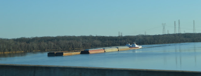
My wife knows that my industrial scenery interests are not limited to just bridges.
Judging from the propwash, the towboat on the side is along for the ride. I wondered why they didn't put it in the "hole" in the front port side of the tow. Then I remembered how the bow of a towboat pushes water even worse than a barge.


No comments:
Post a Comment