Bridge: (Historic Bridges; Satellite)
There are no more locks between here and the Atlantic Ocean. That is, this is the first lock on the St. Lawrence Seaway when going upbound.
 |
| Jacques Bouffard posted Ecluse de Saint- Lambert et le canal de la Rive-Sud. Pat English shared The St Lambert Lock and the South Shore Canal in Montreal. [The bridge in the background looks like the old cantilever bridge rather than the new cable-stayed bridge.] |
 |
| Street View |
 |
| HistoricBridges Historic Bridges explains that the 1859 bridge was a single-track iron tubular-girder bridge built on stone piers. In 1898 they expanded the width of the piers and built a double-track truss bridge around the tubular bridge while accommodating railroad traffic during the construction. This is one of several historical photos in HistoricBridges. |
 |
| Bridges Now and Then posted Victoria Jubilee Bridge, Montreal, QC, 1897. (Wm. Notman & Son) |
Using Street View, I zoomed in on the piers. It makes sense that the 1898 construction also used cut stone because concrete construction had yet to be developed. But I'm surprised that I can't see any seams between the 1859 and 1898 construction. Maybe they are obscured by the rust stains.
 |
| Street View |
 |
| Bridges Now and Then posted Building Montreal's Victoria Bridge, August 7, 1898. (Historic Bridges) |
While I was searching for some other bridges on the St. Lawrence Seaway, I spotted this interesting configuration.
 |
| Satellite |
Normally that type of branch happens in the river because two different routes don't have enough room to join on land. But zooming out reveals that there is not a river bluff restricting land access. In fact, there is only one through route.
 |
| Satellite |
I was confused until I noticed that the road bridge has two different terminations: before and after the north lift bridge.
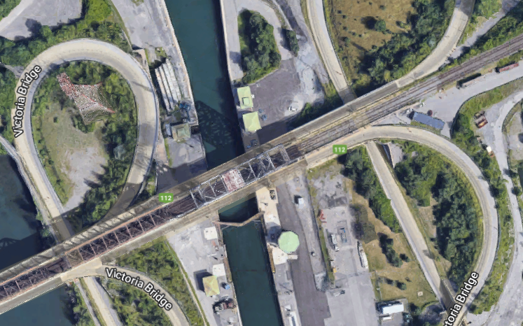 |
| Satellite |
Following the "before" ramp shows that it goes across the south lift bridge and joins the same route-112 road that the "after" ramp goes to. Then it occurred to me that the north lift bridge is the original route and the south route was built as part of the St. Lawrence Seaway project so that rail and road traffic could use the southern bridge while the northern bridge was open for ships. And, of course, the rail and road traffic could use the northern bridge while the southern bridge was open. HistoricBridges confirms this theory and calls the southern route the St. Lambert Diversion Bridge.
 |
| Satellite |
 |
| Sep 2016 photo by Pierre Lahoud via saint-lambert The original bridge was built by the Grand Trunk Railway. "Victoria Bridge was the first bridge to span the St. Lawrence River." This bridge also carries commuter trains. |
A view from the east side (south bank). The railroad bridge is on the left and the vehicle bridge is on the right.
 |
| Trail View, Nov 2022 |
The use of the bridge by commuter trains would help explain why they added the diversion route. Commuter trains run often during the rush hour, and they are very sensitive to delays.
Originally, lanes were added for horse&buggy and streetcar traffic using cantilevers from the trusses. Now the lanes are used for cars.
 |
| Street View |
For the 1958 bridge, they used a dual-deck span with the road on the lower level.
 |
| Street View |
A view of the 1958 diversion bridge and lock from the original bridge.
 |
| Street View |
A view of the original bridge and lock from the diversion bridge.
 |
| Street View |
HistoricBridges explains that when they built the diversion route bridge they planned on adding a second channel and lock. That is why the south tower is wider than normal and the next span to the south is also a double-deck span. Because the south tower is wider than normal, it is strong enough that the north "tower" is really just a column.
 |
| 3D Satellite |
Here is an overview of both lift spans and the lock. Judging from the text with the photo, this freighter is going to drop off some imports in Chicago and then get a load of grain from Thunder Bay. Also, that is a rather tall power line tower.
 |
| David Raddings, Nov 2014 1967 mv"Middlesex Trader" upbound to Chicago & Thunder... |
This shows the diversion route on the left, the original route on the right and the beginning of the road flyover of the diversion route.
I'm glad the towers for the lift bridge are not symmetric because the wide tower on the right right side of the bridge means that this ship is downbound. I presume this freighter is still going down in the locvk because the lift span has not been raised for it to leave. But it looks like it is getting close to the lower-pool level.
 |
| Chaminda Gamage, Apr 2019 |
 |
| Steph Beaudin, Jun 2019 |
 |
| Steph Beaudin, Jun 2019 |
I'm glad the towers for the lift bridge are not symmetric because the wide tower on the right right side of the bridge means that this ship is downbound. I presume this freighter is still going down in the locvk because the lift span has not been raised for it to leave. But it looks like it is getting close to the lower-pool level.
 |
| Alain Quevillon, Jun 2012 |
 |
| 1 of 2 photos posted by the Marine Historical Society of Detroit The tanker Imperial Collingwood in the St. Lambert Lock on April 26, 1959. Assuming that date is correct, this would have been only the second day the St. Lawrence Seaway was open to commercial traffic. J.R. Williams photos from the Jim Bartke/MHSD collection. [They must have recently pulled the stop logs because one of them is still being suspended by the crane.] Marine Historical Society of Detroit shared |
In this photo we know that the ship is down to the lower-pool level. So it looks like the lift of the lock is about the deck height of an ocean-going freighter.
 |
| Mar CT, May 2022 |
This is an interesting bridge over which to take a virtual trip using street view because of the flyover.
 |
| Street View, Jun 2021 |
And the serendipity of a container train on the bridge allowed me to catch an interesting load.
 |
| Street View |
These are the bridges I was looking for that caused me to find this bridge and lock. But they are going to have to wait for another day.
.jpg) |
| Janey Anderson share |
 |
| Henry Vaughan posted The Canadian National Railway’s Victoria (deviation) Bridge over the Saint Lawrence River Montreal from VIA Rail #12 the eastbound “Atlantic” 5/19/81. |
No comments:
Post a Comment