 |
| William Brown posted |
Looking at a satellite image, one notes that they have had serious problems with ice flows. They have added the biggest "ice breakers" I have ever seen on the up-river side of the piers.
I believe the postcard picture is of this bridge which is now a "nowhere to nowhere" bridge.
An old aerial photo shows that this bridge was part of a grade level industrial spur that connected their yard facilities on the east bank with industries on the west bank. It looks like this yard was obsolete by 1939.
Another surprise when looking at a satellite image is the old steel truss bridge used by a trail did not exist in 1939. (Update: it is not an old truss bridge. It is a new truss bridge that was evidently built for the trail.) Given that they have a nice trail head on Hurds Island, that bridge is going to motivate me to get off my rear-end and hike a trail. (Update: I did hike the trail. Search for "Hurd Island" in 20170725.)
I believe the postcard picture is of this bridge which is now a "nowhere to nowhere" bridge.
 |
| I forgot to record the link the first time. Now (May 2017), the 3D image is not as good. |
 |
| Marty Bernard posted CB&Q NW2 9211 crossing the Fox River in Aurora, IL in August 1963 with a Way Freight. Roger Patelski photo [There were still rail-served industries and cabooses back in the 1960s.] |
 |
| 1939 Aerial Photo from ILHAP |
Another surprise when looking at a satellite image is the old steel truss bridge used by a trail did not exist in 1939. (Update: it is not an old truss bridge. It is a new truss bridge that was evidently built for the trail.) Given that they have a nice trail head on Hurds Island, that bridge is going to motivate me to get off my rear-end and hike a trail. (Update: I did hike the trail. Search for "Hurd Island" in 20170725.)
 |
| 20170725 0608 |

 |
| This photo has been moved to 1920 BNSF/CB&Q Hurds Island Bridges over Fox River in Aurora, IL |
 |
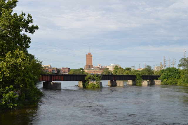
| Greg Kozlick posted Hey there! This is a Google Maps view of Aurora, IL. I'm wondering what this bridge was used for? The BNSF mainline is at the bottom of this photo. Historic Aerials isn't loading and I don't know where to start looking. Thanks! Edward Rethwisch: That bridge was the original "Q" main line and had to bridges until the elevation was completed after ww1 and was still used until the early 90s for the alley job. Now just a land mark. The rail is still on the bridge. Greg Kozlick: Edward Rethwisch Do you have any further info on the alley job? Trying to find info and putting "job" in a Google search just brings up job postings lol Edward Rethwisch: Greg Kozlick the only thing I know is what my father told me about the job. I do know it at one time went to the now park behind where the old now removed police station were it interchanged with the C&NW behind there small engine house. I do have some photos of the alley tracks before they pulled them up. I think the last shipper was the Beacon news a newspaper printer I remember Canadian boxcars there. In the later years it ended there at the Beacon news the last business on the line before abandonment but the line actually went around an old cotton factory that it served and ended at the small C&NW yard on the other side of I think it's New York street now a park along side the Fox River and they also interchanged at that yard to go north to West Chicago on the C&NW. The last steam engines to work the alley job were USRA 0-6-0s out of Eola. I don't think K-2 # 637 ever worked the alley job it was one of the "Q"s steam publicity engines by then. Tom Scholes: Edward Rethwisch It ended at the Beacon News building. It served several of the small businesses along the way. My dad worked for the Q and I can remember they used an ancient steam locomotive to work the alley long after they retired their mainline steam. It is sitting at IRM today. It was on display in a park in Aurora for years but became so vandalized that the city gave it to IRM. If I remember right I think that alley is named Center Ave. |
 |
| Toom Scholes commented on Greg's comment A picture of the bridge when it was the mainline. |
 |
| Dennis DeBruler commented on Greg's post 1950 Aurora North and 1954 Aurora South Quads @ 1:24,000 |
 |
| Craig Duy commented on Greg's post It tied into the main line behind the Aurora station at the north, and at Richards Wilcox at the south per the 1939 aerials. |
 |
| Dave Kuntz posted What purpose did this bridge in Aurora IL serve? I've heard it was the original Fox River crossing of the CB&Q but it looks way newer than the stone arch bridge that now carries BNSF. Robert Weber shared Bill Pauley: Prior to the tracks being elevated, which was completed in November of 1922, the main line for the Q crossed the river there. A double track crossing. |
Dave Kuntz posted two photos with the comment: "A fan sent me an old public domain postcard of a steam engine crossing the now abandoned CB&Q Bridge in Aurora IL that I posted yesterday. It makes for a great before/after comparison."
Dave Kuntz shared with the comment: "Aurora before and after."
Andy Bee: I'm guessing that was a power plant, in the top right corner.
Ray Speerly: Yes, there was a power plant down there and Machinery company that would be off to the right of the picture. That bridge led to the service tracks for downtown business to be switch, would deliver paper to the old Beacon News on that track, it also aload us to get to at one time tracks that led to other business that would be switched on the Aurora Job.
 |
| 1 |
 |
| 2 |
 |
| David Thompson commented on Dave's post Here is the 1964 Aurora Coal and Water Map not much coal or water at that point. ( I'm not sure where I obtained but the notes on the PDF ref to Allen Stanley and Files of Steve Holding 9/2010, so will credit them) |
 |
| David Thompson commented on his post Here is the track Chart. |
No comments:
Post a Comment