 |
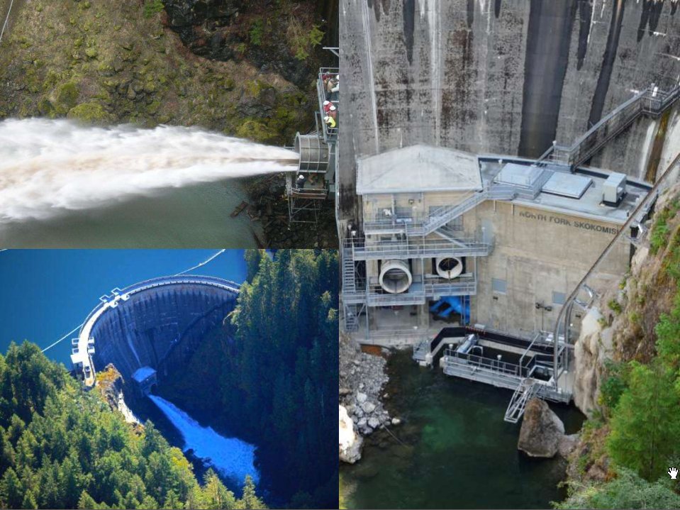
| posted, Cushman Dam Quite a few of the comments concerned the amount of cable that would be needed for this job. [Note the special pads they built for the outriggers.] |
The following video shows the launching of the Net Transition Structure and Floating Surface Collector. The Goggle satellite image linked above was taken after it was installed. (The Bing satellite image does not yet show it.) This structure is used to help transport the salmon fry downstream after hatching. It is part of an agreement with the Skokomish Tribal Nation to settle a $5.8 billion damages claim and to allow the dam to get a long-term license until 2048. [tpu]
 |
| HistoryLink |
 |
| Slide Presentation, p 23 |
 |
| Slide Presentation, p 25 |
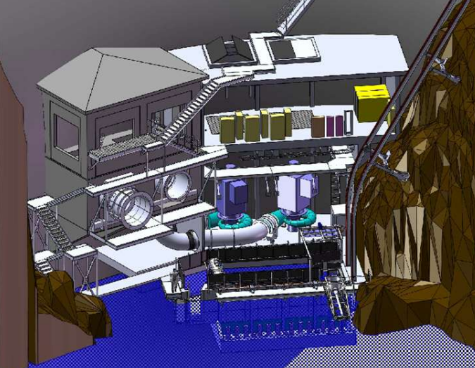
Discharging the draft tubes under the fish collection pool was an issue because it had never been done before. "The design was so sensitive that a 1:5 scale physical model was built in a Northwest Hydraulic Consultants laboratory and used to validate the arrangement. The final design protects the Andritz-manufactured turbines from the hydraulic resonance that may be created by the pool." [HydroWorld]
The fish hopper on the tram is also used to lower fry caught by the Net Transition Structure and Floating Surface Collector at Dam #1 to release them downstream of Dam #2.
Now that we see how they get salmon around the two dams, we will look at the flow issues. Component 1 is the base flow. There is a 160,000 acre-feet water budget. The current agreement is 120-cfs in summer and up to 300-cfs in winter. This variance reflects a more natural variation of the flow and helps restore wet lands along the river's channel. And it provides enough flow during the spawning season so that the salmon can make it to the fish trap after they modified the "Little Falls" rapids a couple of miles downstream from Dam #2 to accommodate a 170 cfs flow.
Component 2 consists of flows in the range of 500-1000-cfs to simulate floods. The timing and size of the "flood flows" will be based on measured rain and snow melt flows into the upper basin. Specifically, 500 cfs will be released for the number of days that the inflow exceeds 3000 cfs, 750 cfs for each day exceeding 4000 cfs, and 1000 cfs for each day the trigger criteria is above 5000 cfs. Note that the river still sees just a fraction of the flows the native river saw. Every five years the outflows will be increased by 5%. [p 7 in Article 407 of the agreement]
Component 3 seems to be an experiment as to how to flush sediment out of the main channel of the Skokomish River using water from the North Fork After a major storm event, they should allow 2,2000 cfs to flow for 48 hours. [Slide Presentation, p 21] A major storm is defined as an inflow over "9800 cfs, or 15% above flood stage, whichever is greater, between October 1 and February 15 of each year." [p 7 in Article 407 of the agreement] This rate should fill the Mainstem channel to slightly less than bank-full capacity.
There are also specifications as to how fast they can ramp the flows up and down.
The power company will maintain a minimum impoundment elevation in Lake Cushman (Dam #1 pool) of between 735' and 738' from Memorial Day weekend through Labor Day weekend. During November 1 through March 31, a minimum impoundment of 690' will be maintained. I believe the summer restriction means that even if power is needed to run air conditioners, the hydro-plant needs to be turned off if the water level would become too low for recreational uses such as pier access, favorite fishing spots being covered, boat launches, etc. I assume the winter restriction is to maintain reserves in case of a drought. Lake Kokanee (Dam #2 pool) shall be maintained between 474' and 480' except for maintenance requirements of the intake or spillway. [Article 405 of the agreement] I'm surprised they don't specify maximums to leave reserve capacity for flood control. Or maybe it rains so much in the Northwest that every year has floods and the rivers can handle it.
There are other provisions in the agreement such as 1,000 acres of land was transferred and the tribe gets "7.25% of the value of power from Cushman #2." [Slide Presentation, p 18] Some federal money was used for the construction because it was "renewable energy with environmental benefits." [Slide Presentation, p 22]
A collection of 1920s construction photos includes the spiral penstock around the turbine. The river valve we see today was installed in one of two gateways used to pass water during construction. These are the only two photos I looked at because, as with most collections, I can't copy the photos. And it frustrates me to see historical photos that I can't use.
Many HAER photos have not been scanned. That is the first time I have seen so many HAER photos that have not been scanned. I did find pictures of the spillway which caused me to take another look at the satellite image.
 |
| HAER WASH,23-HOPO.V,1-A--15 VIEW OF DISCHARGE THROUGH SPILLWAY CHUTE FROM WEST RETAINING WALL, FACING SOUTH. STANDING WAVES ARE VISIBLE. WATER ELEVATION MEASURED 4.8 FEET ABOVE CREST. December 1933 - Cushman No. 1 Hydroelectric Power Plant, Spillway, North Fork of Skokomish River, 5 miles West of Hood Canal, Hoodsport, Mason County, WA |
No comments:
Post a Comment