YS&T = Youngstown Steel & Tube
These notes cover Illinois Steel South Works on the north side of the river and YS&T(1924)/Iroquois Steel(1910) on the south side. When US Steel was created in 1901, Illinois Steel became US Steel South Works. That is, old photos of the South Works are here and newer photos are in USS South Works. This plant was known as the South Works because Illinois Steel started along the North Branch of the Chicago River (rolling mill) and in Joliet (blast furnaces). It then moved here after the mouth of the Calumet River was developed for navigation.
These notes cover Illinois Steel South Works on the north side of the river and YS&T(1924)/Iroquois Steel(1910) on the south side. When US Steel was created in 1901, Illinois Steel became US Steel South Works. That is, old photos of the South Works are here and newer photos are in USS South Works. This plant was known as the South Works because Illinois Steel started along the North Branch of the Chicago River (rolling mill) and in Joliet (blast furnaces). It then moved here after the mouth of the Calumet River was developed for navigation.
Likewise, this covers the older plants of YS&T because they later moved to Indiana Harbor.
In 1910, Iroquois Steel built south of the Calumet River entrance. It expanded to the north by filling in the lake. In 1923 the company became the Youngstown Steel and Tube Company. "In 1951 the plant had 3 blast furnaces, 70 coke ovens, and 800 employees. Its main products were coke and pig iron." [SEsideIndustrialHistory, p22] Since then this land has become and international shipping dock called Iroquois Landing International Terminal.
Scroll down to Youngstown in idaillinois search results.
 |
| Michael Siola posted |
This looks like a different colorization of the above photo.
 |
Jim Holechko posted At one time as late as 1979, the Calumet River and Lake Michigan on the South side of Chicago was home to 8 steel Mills, part of the Big 8 in Steel. US Steel,J&L Inland,Wisconsin Steel, Youngstown ,Valley Mould and Republic Steel. Today, there are none! Some call it Globalization. It was the demise of Union steelmaking. I call it Corporate greed to take these Mills overseas. Today only 2 Steel Mills exist on the south tip of Lake Michigan exist. US Steel and Cleavland Cliffs Jonell Pointer plagiarized Jim including the misspelling of Cleveland. |
 |
| MWRD posted Construction of the MWRD’s 95th Street pumping station, viewed to the east from atop a gas tank on Baltimore Avenue just south of 95th Street in Chicago on June 5, 1924. Dennis DeBruler: In the background are the blast furnaces of Iroquois Steel, and in the right background is the B&O Bridge before it was hit. |
 |
| Jo Pin posted The 1903 view of construction work on the 95th Street bridge over the Calumet River way before 1979, when the Blues Brothers mobile jumped the Calumet River! Street level view, looking east down the 95th Street Bridge at men placing boards on the surface around streetcar tracks that are laid on the inside lanes. Two women are walking toward the bridge in the foreground. The 95th Street Bridge spanned the Calumet River in the South Chicago community area of Chicago, Illinois. (Creator - Chicago Daily News, Inc.) Rod Sellers: View is east. Iroquois Iron [my emphasis] in distance at right. David Utech: An abundant use of Chicago's Y-shaped "Municipal Device" before it was officially adopted by City Council. |
 |
| Tony Margis posted Harbor entrance and Illinois Steel Works, So. Chicago. Detroit Publishing Co. , publisher. Date Created/Published: [between 1890 and 1901] Bob Lalich Taken from the old EJ&E swing bridge prior to construction of the Iroquois/YS&T plant. |
 |
| Association for Great Lakes Maritime History posted The Illinois Steel Works at the mouth of the Calumet River in South, Chicago, Ill. with the railroad car barge No. 4 in the foreground, circa 1900 (Image Source: Library of Congress – Detroit Publishing Co. Collection). In the background are the whaleback freighter Pathfinder and the stern of the schooner barge Madeira. The collection notes show the date as circa 1890-1901. Based on the history of the vessels, the photograph is circa 1900. The name of the photographer is not included in the notes for the image, which was created from a dry plate negative. [The description continues with the history of the boats.] |
A lighter exposure of the above. You can better see the blast furnace stoves, but the smoke is subdued.
 |
| Tony Margis posted Illinois Steel Works, later became US Steel South Works in 1910.
Shawn Keith: The barges had the very creative names of No. 1, No. 2, No. 3, and No. 4. They were very unsuccessful and none of them lasted long, with three of them winding up on the bottom. Tim Kilboy: Those old furnaces... so similar, but so different from later designs. This photo predates fce E which appeared to the south in about 1906, I think. Any ideas on how the charging worked? the materials must have gone up through one of the towers then conveyed to the top of the furnace for charging. Charles Lamar: Tim Kilboy fascinating photo. The blast furnace shown is open to the atmosphere- no uptakes or downcomer. The elevators taking material up were very substantial. On tour at the Joliet USS plant and seen recently about a just shutdown British furnace it was said that materials were just taken by wheelbarrow and thrown in the open furnace top. These furnaces made way less than 1000 tons per day. Note the "Whaleback" ore boat on the North bank of the river by the blast furnace. |
 |
| Association for Great Lakes Maritime History posted The railroad car barge No. 1 near the mouth of the Calumet River in South Chicago, Ill., circa 1900. (Image Source: Library of Congress – Detroit Publishing Co. Collection). Although not included in the notes for the image, the name of the vessel can be found on the stern of a lifeboat on top of its pilothouse> In the background is the Illinois Steel Works. Also shown is the 1876 lighthouse on the north shore of the Calumet River which had been engulfed by the steel works, along with the U.S. Life-Saving Service Station. The name of the photographer is not included in the notes for the image, which was created from a dry plate negative. Image Information Source: [The description continues with the history of the barge. I could not find the image that they implied was already in these notes.] |
 |
| Steve Vanden Bosch posted Chicago Harbor with a Whaleback and a Lake Michigan Carferry Barge on the near left. This photo is from the Library of Congress. |
 |
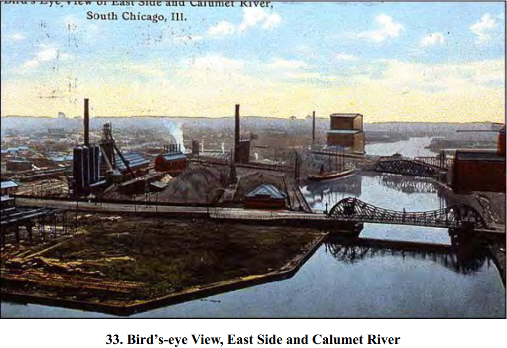
| Dwayne Stegner posted, cropped 1920s postcard of Illinois Steel in South Chicago [Dwayne's post also included an image of the backside of the postcard.] |
In 1910, Iroquois Steel built south of the Calumet River entrance. It expanded to the north by filling in the lake. In 1923 the company became the Youngstown Steel and Tube Company. "In 1951 the plant had 3 blast furnaces, 70 coke ovens, and 800 employees. Its main products were coke and pig iron." [SEsideIndustrialHistory, p22] Since then this land has become and international shipping dock called Iroquois Landing International Terminal.
 |
| SEsideIndustrialHistory, p22 |
I believe the plant started south of 95th Street and grew north as more of the lake was filled in. A 1907 view shows two blast furnaces south of 95th Street. IDAillinois has an index page and search results.
 |
| safe_image for Tugboat on the Calumet river in Chicago This looks like what’s also in my home movie which I posted last year. |
I included the South Works that was north of the river as well to show that they also seriously polluted the air.
 |
| 1938 Aerial Photo from ILHAP |
Zooming in on the area south of 95th in the lower-left corner of the above image shows that Youngstown had abandoned that area in favor of a larger facility on the landfill.
 |
| 1938 Aerial Photo from ILHAP |
 |
| This photo was moved to Iroquois Landing International Terminal |
 |
| Twelfth Photo in a Media Set by Rod Sellers Rod Sellers 1938 aerial photo of Youngstown Steel. Gas holder, casting long shadow, is at top, center of photo. |
 |
| One of thirty photos in an album by Bill Staniec The Iroquois mill is in the foreground and the South Works is in the background. |
John Groves provided two photos as comments on the above photo:
 |
| 1 |
 |
| 2 |
 |
| Michael Mora posted Near US Steel South Works at mouth of Calumet River, 1941-42. Looking east/southeast from 91st and Green Bay/Avenue O at Youngstown Sheet & Tube plant across the river. Old Coast Guard station and EJ&E railway swing bridge on far left. By Earl H. Reed, School of Art Institute of Chgo, Archival Image Collection Bob Lalich The photo was taken near South Works, but the blast furnaces and coke plant seen in the background here were Youngstown Sheet & Tube across the river from South Works. The old Coast Guard station can be seen on the left edge. Mike Kemp Bob Lalich so Youngstown used to be on the land that became the Iroquois Landing port? I didn't know that! Bob Lalich Mike Kemp - yes, the plant at the mouth of the river was built on landfill by Iroquois Iron around 1912. Iroquois had outgrown their first Chicago plant at 95th St and the river. Iroquois morphed into Steel & Tube Co of America, then YS&T. The South Chicago plant made pig iron, no steel conversion. It closed around 1960. Charles Nosich I can see that gas tank/tower off in the distance at 97th & Baltimore Bob Lalich Charles Nosich - the gas holder [gasometer] in this photo was located at the mouth of the Calumet River. It was part of the YS&T coke plant. [I could not find the gas holder in the 1938 aerial photo.] |
 |
| Rod Sellers posted Number 5 Trolley heading west on 95th Street crossing Chicago Short Line tracks just west of Avenue N. The gas holder in the distance at left was part of the Youngstown coke plant. Statue on the corner of Frank Kralj's Tavern at 95th Street and Avenue M and Texaco station at 95th and Ewing are barely visible if photo is enlarged. Attached photo is the tavern and statue. Thanks to Bob Lalich for assistance in identifying photo. |
The "major construction" mentioned below would have been the steel plant.
Paul Petraitis posted two photos with the comment: "Calumet River Harbor 1876 before major construction."
Paul Petraitis From "the calumet Panorama" CHS, unknown photographer, shot from the old lighthouse looking south
The mouth of the Calumet River was originally much closer to Ewing Avenue, if not 95th Street. The channel we see now is between landfills by US Steel on the north and youngstown on the south.
Michael Mora posted four photos with the comment: "Photos of first lighthouses located on north shore of Calumet River/Harbor from 1851-1976."
Dwayne Stegner posted two images with the comment: "1942 Calumet River."
Michael Mora posted three photos with the comment: "Found some circa 1890 photos of Calumet Harbor area under construction and early industry, by Army Engineers on National Archives website. Location not labeled in source." I'm using the images adjusted by David Daruszka.
Paul Petraitis posted two photos with the comment: "Calumet River Harbor 1876 before major construction."
Paul Petraitis From "the calumet Panorama" CHS, unknown photographer, shot from the old lighthouse looking south
 |
| 1 Paul Petraitis Looking SSE from atop the old lighthouse (b.1851 I believe?)...the "original mouth" has been blocked by beach sand and the current mouth (in the foreground) was dug by Col. Bowen's Dock and Dredge Co that had their offices on nearby Houston...that's the Indiana dunes in the distance on the left...I think the Indiana State line is just beyond those whispy trees on the beach there...but whose 2 story house is that on the right? [And a two masted schooner was trapped when the original mouth closed?] |
 |
| 2 |
Michael Mora posted four photos with the comment: "Photos of first lighthouses located on north shore of Calumet River/Harbor from 1851-1976."
 |
| 1 Circa 1876, first lighthouse on north shore of river, around 91st and Harbor Ave, lhdigest.com.Recommended by Navy in 1837 report, built in 1851 using stone quarried near Blue Island and transported down river by barge. Only lit 1852-55, and 1873-76, when Army Engineers built harbor with piers on both sides of river. From 1855-73, sold to major landowner George W. Clarke, rented to Oehmich family who owned property across the river. Then government bought it back. |
 |
| 2 Circa late 1890s, old lighthouse next to U.S. Life Saving Service station (later U.S. Coast Guard), engulfed by South Works plant, loc.gov. In 1876, old lighthouse replaced by wooden light tower at head of north pier and goes dark again, for good. 1880s, harbor enlarged, pier extended more than 1000 feet lakeward. Light tower now known as Calumet Pierhead Light. 1890, U.S. Life Saving Service station built. South Works soon filled in the lakefront through 200 feet from end of pier. Rod Sellers: Photo also shows Lake Michigan [rail] Car Ferry in foreground. |
 |
| 3 1914, pierhead light with fog signal bell, National Archives, catalog.archives.gov. In 1898, wooden light tower replaced with cast-iron tower. Fog signal added, first steam whistle then automated bell that rang every 20 seconds. After 1906, pierhead light downgraded because outer harbor and long breakwater built north of river with lighthouse at tip over 1 mile lakeward. |
 |
| 4 1949, pierhead light on lakefront/tip of South Works land, lighhousefriends.com. In 1920s, last stub of north pier removed, pierhead light moved to tip of South Works/north shore of rivfer. Pierhead light stood sentinel until 1976. Struck by a ship, then demolished by Coast Guard. |
 |
| Rod Sellers commented on Michael's posting South Chicago 1874, lighthouse at right David W Swanson This drawing shows one of the slips on the south side of the river. My father once told me that sturgeon fishing boats docked there. |
 |
| Rod Sellers commented on his post A map shows a 1910 view of area. |
 |
| Paul Petraitis posted The harbor in 1928 |
 |
| Rod Sellers posted From 1930 Chicago Street Guide. Notice any differences with current situation? [The group is public, so you should be able to see the answers by clicking the "posted" link.] |
 |
| Tony Margis posted Back, back, back... 1892 map by Rufus Blanchard What's missing in this picture? Everything, right? |
 |
| Tony Margis posted Compared to a 1929 map of the area.... |
Dwayne Stegner posted two images with the comment: "1942 Calumet River."
 |
| 1 |
 |
| 2, cropped |
 |
| MWRD posted Historical photo of the week: Construction of the MWRD’s 95th Street Pumping station viewed to the east from atop a gas tank on Baltimore Ave just south of 95th Street in Chicago on June 5, 1924. The pumping station went into service in 1925. Bob Lalich The blast furnaces in the background were Iroquois Iron's furnace plant south of 95th St. Iroquois built a bigger furnace plant at the mouth of the Calumet River around 1912 and once completed, abandoned the plant seen here. MWRD posted Construction of the MWRD’s 95th Street Pumping Station, viewed to the east from atop a gas tank on Baltimore Ave just south of 95th St in Chicago on June 5, 1924. The pumping station went into service in 1925 [This photo is redundant. (I already have included it above.) But it is worth repeating.] Dennis DeBruler shared The bascule bridge on the right was B&O. The two blast furnaces are the original location of the Iroquois Steel Co. But what is the power plant with six smokestacks in the middle of the background? State Line was southeast of here, not east. Bob Lalich: The building with six stacks was part of the Iroquois Iron plant on the east side of the river, likely the blower house for the two blast furnaces. [There are some more comments about the building with smokestacks probably being a blower house and not the 100th Street Edison Plant.] |
 |
| Dennis DeBruler commented on Bob's comment Agreed. Back then the air compressors were reciprocating and were a couple or three stories tall. They needed a big building. |
 |
| Rod Sellers posted 95th Street bridge, view east, nearing completion 1903. One of the earliest trunnion bascule bridges built in Chicago. Replaced a swing bridge originally at 95th Street. Tracks are for trolley cars. Replaced by current 95th Street bridge in 1958. Iroquois Iron blast furnace visible at back right. |
 |
| June Jurasko commented on Rod's post Picture you showed June 12. Daniel Bovino posted Nighttime photograph (long exposure time) of the Iroquois Iron Works taken from the north bank at the mouth of the Calumet River c. 1913. Tom Shepherd shared Bob Lalich: This photo is the old plant at 95th St. Rod Sellers: Iroquois became Sheet and Tube Company of America then Youngstown Sheet and Tube. |
A much higher resolution of the above.
 |
| Rod Sellers posted |
|
| Michael Mora posted Near US Steel South Works at mouth of Calumet River, 1941-42. Looking east/southeast from 91st and Green Bay/Avenue O at Youngstown Sheet & Tube plant across the river. Old Coast Guard station and EJ&E railway swing bridge on far left. By Earl H. Reed, School of Art Institute of Chgo, Archival Image Collection Bob Lalich The photo was taken near South Works, but the blast furnaces and coke plant seen in the background here were Youngstown Sheet & Tube across the river from South Works. The old Coast Guard station can be seen on the left edge. Mike Kemp Bob Lalich so Youngstown used to be on the land that became the Iroquois Landing port? I didn't know that! Bob Lalich Mike Kemp - yes, the plant at the mouth of the river was built on landfill by Iroquois Iron around 1912. Iroquois had outgrown their first Chicago plant at 95th St and the river. Iroquois morphed into Steel & Tube Co of America, then YS&T. The South Chicago plant made pig iron, no steel conversion. It closed around 1960. Charles Nosich I can see that gas tank/tower off in the distance at 97th & Baltimore Bob Lalich Charles Nosich - the gas holder [gasometer] in this photo was located at the mouth of the Calumet River. It was part of the YS&T coke plant. |
 |
| Tony Margis posted Steel Mills at mouth of Calumet river Chicago. (1939) William Bork Youngstown Sheet and Tube. [Looking SE] |
 |
| Robert Campbell posted The William B. Schiller at South Chicago in 1939. The photo from the collection of the Milwaukee Public Library. Lou Gerard: Neat shot Bob! She is actually tied up across from South Works at the Youngstown dock. |
 |
| Michael Mora posted "Aerial View of Chicago, 95th and [Ewing], looking North, 1930." Chicago Aerial Survey, by Percy H. Sloan. Newberry Library, Chicago and the Midwest Collection http://collections.carli.illinois.edu/…/nby_…/id/5327/rec/87 Larry Grzywinski Sorry but that is not 95th and Ewing Ave. 92nd across the river, Ewing in the foreground. Michael Mora Just quoting library's photo caption. It says 95th and "Irving" so I did correct street name mistake. Probably no one who knew Southeast Side at Newberry Library when this was archived there. But the 1930 airplane was probably flying over 95th and Ewing when photo taken. A few other aerial photos in this series are captioned that way too. |
 |
| Rod Sellers commented on Michael's post Another photo from the same collection. 108th and Calumet River looking NE 1930. Great view of northeast portion of Calumet Park still being filled in for expansion. Ernest J. Gonzalez Rod Sellers doesn’t even look like Republic Steel was built yet. Rod Sellers Map only extends to about 112th Street. Republic (formerly Interstate Iron and Steel) in 1930 would have been south of this at around 118th Street. Larry Grzywinski The part of Republic Steel north of 116th Streel was constructed in the early 1940's. |
Michael Mora posted three photos with the comment: "Found some circa 1890 photos of Calumet Harbor area under construction and early industry, by Army Engineers on National Archives website. Location not labeled in source." I'm using the images adjusted by David Daruszka.
 |
| 1 "Ship and vacant lot next to waterway" - Found some circa 1890 photos of Calumet Harbor area under construction and early industry, by Army Engineers on National Archives website. Location not labeled in source. https:// |
 |
| 2 "Construction site and ship next to breakwater" - Found some circa 1890 photos of Calumet Harbor area under construction and early industry, by Army Engineers on National Archives website. Location not labeled in source. https:// |
 |
| 3 "Waterway with ship" - Found some circa 1890 photos of Calumet Harbor area under construction and early industry, by Army Engineers on National Archives website. Location not labeled in source. https:// |
 |
| David Daruszka updated Bob Lalich That is the walkway from the 89th St gate. |
 |
| This photo was moved to Iroquois Landing International Terminal |
 |
| This photo was moved to Iroquois Landing International Terminal |
 |
| This photo was moved to Iroquois Landing International Terminal |
 |
| James Torgeson posted The USS South Works. Note the two salties at the cargo pier on the Calumet River. Kenneth Treharn: When I worked at G.A.T.X. they bought a lot of heavy plate steel from them. James Torgeson: Kenneth Treharn Yep, heavy flats and structurals were their bread and butter. Michael Maitland: Great shot, hard to believe all gone. The field in the foreground also had a fully integrated steel mill at one time - Iroquois Works of YST I believe. James Torgeson: Michael Maitland Yes, the Iroquois plant closed around 1960. |
Ken Morrison posted a photo of a CN local on the South Chicago Bridge lead about to cross 98th Street with the comment: "I didn't know the South Chicago Bridge lead was still active. I thought the marine terminal there was getting its rail service from the Chicago Short Line. Now I know better. E. 98th St. crossing...looking N."
Zaky Joseph: CN takes a lot of lumber cars and other cars to the port there on a round trip originating from Kirk Yard in Gary. Usually during the week, arriving west at the port in the morning and departing east to Kirk later in the morning or afternoon.
(new window) It goes all the way down past the grain elevators.
Rolling first steel rail in South Works in 1880
Rolling first steel rail in South Works in 1880
The first steel rail in America was rolled in the North Works on May 24, 1865. [DeBruler] Rail must have been an important product for the South Works. In the 1980s, the last new mill considered for the South Works was a mill for rolling rail. [Cornell] But evidently management kept insisting on more concessions from the state as well as the union, and it never did get built. [ChicagoTribune] On Apr 10, 1992 the plant was shutdown with fewer than 700 workers remaining. [Facebook]
No comments:
Post a Comment