"This landmark work of a famous engineering firm [Modjeski and Masters] consists of two identical cantilever truss bridge units. As such, the bridge contains a special double anchor pier, and at this point for visual continuity, the end posts are vertical rather then inclined, giving the truss a continuous appearance at this point." [Historic Bridges]
 |
| Postcard via Bridge Hunter |
 |
| Photo taken by C Hanchey in August 2011 via Bridge Hunter, License: Creative Commons Attribution-NonCommercial (CC BY-NC) [Note the two trusses of the Pennsy RR bridge in the background.] |
Until I saw this photo, I never appreciated that this bridge is two cantilever bridges that are joined in the middle of the river. First of all, there are four towers. But what caught my eye is that there was a pier between two of the towers. Looking at the other photos, it becomes obvious that that pier anchors the south anchor span of the north cantilever bridge and the north anchor span of the south cantilever bridge.
 |
Pete Zimmerman posted Sidewheeler river steamer of Louisville & Cincinnati Pcket Co. Photographed: at Louisville, Kentucky, 1929 Otto Perry photographer, Denver Public Library Special Collections Bridges Now and Then posted The George Rogers Clark Memorial Bridge over the Ohio River, linking Louisville, Kentucky, and Jeffersonville, Indiana, 1929. (Industrial History) Theron Stratton: Looks like there is no traffic on the bridge Bridges Now and Then: Theron Stratton It opened in October, 1929, may not be open yet. |
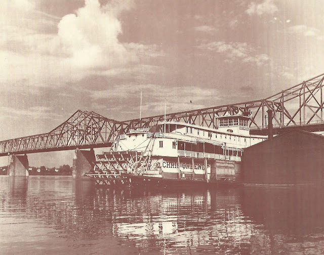 |
| Rob Minton posted Str. Chris Greene at the Louisville wharfboat. William H. and Mary Bill Bauer Collection |
 |
| Greg Coleman posted J.B. Rail Photog shared Louisville, KY, when trains lined the Waterfront. |
 |
| weather_lane via Dennis DeBruler [The approach to the K&I Bridge on the left, the NS/K&IT Youngtown Yard in the middle, the easy to see Pennsy (14th Street) Railroad Bridge and the hard to see George Rogers Clark Bridge.] |
I include a closeup because we can better see the Pennsy bridge and the control structure of the McAlpine Dam.
 |
| Photo taken by C Hanchey in August 2011 via Bridge Hunter, License: Creative Commons Attribution-NonCommercial (CC BY-NC) |
"Federal Standard Cream" is an interesting bridge color. At least Kentucky is not letting all of its truss bridges rot away.
 |
| Andrzej Mucka, Jan 2021, cropped |
 |
| J.P. comment in Bridge Hunter |
 |
| Mary S. Maes posted, cropped Cross this bridge over Ohio River from Jeffersonville, Indiana, to Louisville, Kentucky |
 |
| Kentucky Drone posted Crounse Towboats On The River Crounse Corporation Enid Dibert heading into McAlipine Locks this morning with 15 empties this morning during sunrise. |
 |
| Edward William Stephon Tanner posted Dennis DeBruler: George Rogers Clark Memorial Bridge 38°15'51.1"N 85°45'05.5"W |
 |
| One of two photos posted by Rob Minton Str. JASON going under the Clark Memorial Bridge in Louisville. Date not given, probably ca. 1946. Bauer Collection James E Reising: Note the lack of traffic on the Clark bridge....and it was the only bridge in town at that time...but it was a toll bridge. |
This post was the motivation to document this bridge. It is a little difficult to see with the black on black, but an upbound tow got spun around and is now heading downstream sideways! Several of the barges then allided with the McAlpine Dam. A Facebook comment said "engine 2 failed."
 |
| Screenshot |
Look at the piers in the screenshot above to see how high the river was. We also see how high the river was in this photo.
 |
| USACE photo by Katie Newton via ProgressiveFarmer via DeBruler "Note the Ohio River is as high downstream as it was upstream at the 27' fall of the Falls on the Ohio last December." |
 |
| safe_image for 1929: The Opening of a Bridge Between Kentucky and Indiana — Transportation History, Photo Credit: Public Domain "In 1949, however, the Louisville Municipal Bridge was officially renamed the George Rogers Clark Memorial Bridge in honor of the U.S. military hero who founded Louisville during the American Revolutionary War." This was the first bridge in the area for pedestrians and vehicles. It was the only bridge for non-motorized traffic until 2014 when the Big Four Bridge was converted to a trail. |
Mar 1, 2024:
 |
| 11:13 video Trapped driver rescued from semi hanging over Louisville bridge | FULL RESCUE |
 |
| 1:49 news report |
 |
| Facebook Reel |
Apr 4, 2024:
 |
| Ian Crawford posted, cropped High water at Louisville (4/4/24). [Buildings are in water in Marietta, OH.] |
The first level of the historic wharf was also under water.
 |
| Ian Crawford posted, cropped High water at Louisville (4/4/24). |
 |
| Street View, Sep 2020 |
No comments:
Post a Comment