 |
| John Weeks, 1940 |
It is rather obvious that the location was determined by where the river was narrowest.
 |
| 1972 Greenville Quadrangle @ 1:62,500 |
Unfortunately, the sharp curve in the river upstream from that location caused swift cross-currents at the bridge. "Riverboat operators have to round a sharp bend, then aim for one of the bridge piers, with the current pushing the head of the barge tow away from the pier at the last second. This is something that only highly experienced river pilots can attempt, and it is something that has gone wrong with deadly consequences a number of times. Replacing the bridge became more of a matter of safety than a structural issue." The bridge carried several utility lines because the swift currents kept exposing underground lines. [John Weeks, 1940]
 |
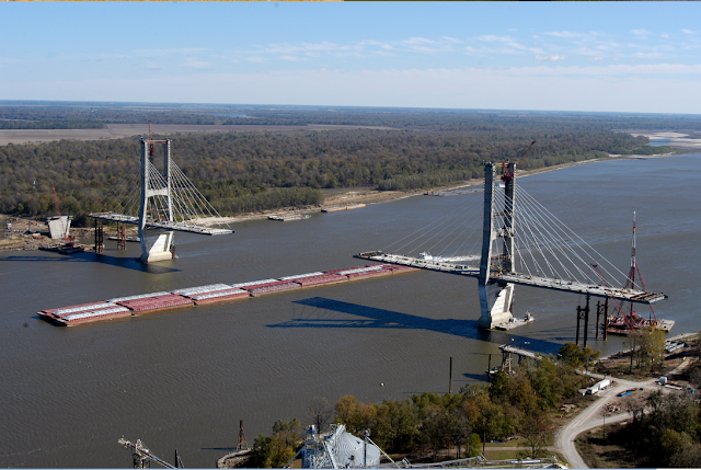
John Weeks, 2010
[The east tower] |
The replacement structure, a giant cable stayed bridge, is situated about about 2,800 feet downriver. It is located on a straight section of the river with a 1,300 foot span between the two 425 foot tall bridge towers. Various web sites, including the official project web site, claimed that this would be the largest cable stay bridge in North America when completed. That claim appears to be incorrect given that the Cooper River Bridge in Charleston, South Carolina, has a span of over 1,500 feet and towers that are 575 feet tall. When the Greenville Bridge opened, it was the second largest cable stayed bridge in the US based on the 1,378 foot main channel span. It held the number two spot only nine months until the John James Audubon Bridge opened in May of 2011, which pushed the Greenville Bridge back to third place. [John Weeks]
The main part of the bridge was completed in 2006. But, due to funding problems, building the approaches was just beginning.
 |
Massman Construction Co. posted
From all of us at Massman, have a safe and happy Independence Day weekend!
[I would think they would take a more current photo rather than show the bridge with no road connected to it.] |
 |
Terry Holder posted, cropped
Good morning Greenville Mississippi |
 |
| Marcus Matheny commented on Terry's post |
 |
Drew Lawrence posted, cropped
Greenville NB |
I remember hearing about a "bridge to nowhere" on the Mississippi River. Now I understand where it was.
 |
| Provided by bridge project manager via John Week, 2010 |
I keep forgetting that approaches to bridges that allow ocean going ships to pass under are non-trivial bridges in their own right. The height of the bridge is 121' above water. But do ships really come this far up the river? The old bridge had an even higher clearance of 130'.
 |
| John Week, 1940 |
 |
| Massman |
The tow above with just 21 barges is rather small for the lower Mississippi. The photo below is the inspiration for this research and shows a 40-barge tow that is eight barges wide. Upbound, they use narrow tows to reduce the resistance to the current. And since their is plenty of current flowing past the rudder, they have good control of the tow. Downbound, where the current past the rudder is low, they use short tows so that it is easier to fit the tows around the bends in the river.
 |
| One of four photos posted by John Vize |
 |
Massman
"The bridge's substructure consists of two main river piers founded on dredged caissons extending 120 feet below the river bottom and supports the main towers that soar approximately 425 feet above the river. This resulted in a total pier height of over 600 feet. The two end piers each rest on 15 drilled shafts that are over 6-foot in diameter. The normal depth of water during construction was between 60 and 80 feet. The completed bridge, with a main span of 1,378 feet, is one of the longest cable-stayed bridges in the United States and the longest span on the lower Mississippi River. The construction method used to build the caissons for the two main river piers was highly specialized. The piers were built using a floating caisson structure and a "top down" construction technique. This method necessitated a major breakwater be built using 60-inch diameter steel piling and a "V" shaped sheet pile structure, to produce a tolerable work environment in the fast current. This current, which has unobstructed river velocities ranging from 4 to 11 feet per second, required that Massman develop a caisson guide system capable of holding the floating concrete pier in place during the sinking operation. Massman also developed a pneumatic buoyancy support system to keep the caissons afloat as the wall sections which were continually built up on top of the caissons. Just prior to touch-down the caissons weighed just less than 24,000 tons each. To address the scour around the new piers created by the changed river hydraulics, Massman contracted with the United States Army Corps of Engineer to install an articulated concrete mattress on the river bottom to protect the two main piers, while 40,000 tons of riprap were placed around the pier located on the riverbank."
|
A sequence of Google Earth images showing the construction of the approaches and the removal of the old bridge.


No comments:
Post a Comment