See also:
Los Angeles: I-110 vs. I-105
 |
| Highway Engineering Discoveries posted Judge Harry Pregerson Interchange Jim K. Georges: The photo is I-110 at I-105. https://goo.gl/maps/AaV95Pc52c872obv7 |
I presume this photo is of this interchange.
 |
| Historical Los Angeles USA posted A staged view of the four-level freeway interchange Downtown Los Angeles (1950) This staged photograph from 1950 offers a glimpse into the ambitious urban planning of Los Angeles as the city embraced the automobile era. The intricate four-level freeway interchange reflects the innovative engineering that defined mid-century Los Angeles. As traffic increased, planners recognized the need for extensive highway systems to facilitate mobility. This interchange not only symbolizes the growth of the city but also the changing landscape of American transportation. The photograph captures a moment when freeways became a crucial part of daily life, shaping the city’s future and its sprawling layout. [All those words and no mention that the automobile, oil and tire industries bought the streetcar system and tore it up.] Clark Ryan: Trucks weren't allowed on Pasadena Fwy. Or were they? They aren't now. |
 |
| Highway Engineering Discoveries posted Los Angeles Interchange, United States of America Craig MacDonald: The 110-105! Went through this a few times, looks amazing going on the 110 northbound straight through |
 |
| Jack Feldman posted 1953 – Aerial view looking north toward the Four Level Interchange showing the early construction of the Harbor Freeway (then US-6/SR-11, now CA-110) through downtown Los Angeles. At lower-right is the Jonathan Club at Figueroa and 6th Streets. The Four Level, linking US-101, CA-110, and the Pasadena Freeway, was the world’s first four-level stack interchange.(https://waterandpower.org/.../Early_City_Views%20(1925%20...) |
 |
| Highway Engineering Discoveries posted USA |
 |
| Highway Engineering Discoveries posted Los Angeles, Aerial of Judge Harry Pregerson Interchange and Highway Jim K. Georges: I-110 (Harbor Freeway) at I-105 (Century Freeway) |
 |
| Highway Engineering Discoveries posted LA Interchange 😍 Los Angeles Interchange, United States of America |
 |
| Highway Engineering Discoveries posted California Jonathan Lippard: Worth risking the ticket to go solo on the HOV flyover for the view (~100 feet in the air). Luanne Martel: Do it really look like that? Someone from from Cali talk talk to me is it real? |
 |
| Dennis DeBruler commented on Luanne's comment Yes, https://www.google.com/maps/@33.9271866,-118.2807013,1427m/data=!3m1!1e3?entry=ttu |
 |
| Highway Engineering Discoveries posted California Jim K. Georges: I-110 looking north at I-105 last to right in Los Angeles. |
 |
| Highway Engineering Discoveries posted Usa Highway Engineering Discoveries posted California ,USA |
In addition to connecting the local lanes in all the directions, I think it connects eastbound and westbound express lanes to northbound express lanes and southbound express lane to westbound express lane. and a track from a tunnel going westbound and local roads thread their way through the maze of overpasses.
The stack interchange is over 103' (31.4m) high. Before the interchange opened, it was used to make the 1994 Speed movie. It was also used in 2011 and 2015 to make Samsara and La La Land.[wikipedia]
 |
| Street View |
Los Angeles: I-110 vs. I-101
 |
| History's Mirror posted In 1981, the four-level freeway interchange in Los Angeles, connecting the Harbor, Pasadena, Hollywood, and San Bernardino freeways, was a stunning engineering marvel. [The rest of the description is platitudes.] Historical Los Angeles USA posted the same AI generated text Bill Bielby: Glen Norman I did a reverse image search and found the source, with photo credit. You have to wonder, who are these Historical ____ USA people, and what's in it for them? https://tessa2.lapl.org/digital/collection/photos/id/124846/ [It turns out that the source of the erroneous freeway names is a librarian.] Opher Banarie: 1981? The picture might be from 1981, but The Stack was built in 1949: The Four-Level Interchange at the junction of U.S. Route 101 (the Hollywood Freeway and Santa Ana Freeway) and State Route 110 (the Harbor Freeway and Arroyo Seco Parkway) is a stunning feat of modern engineering, with a style you might not have time to appreciate as you’re negotiating your lane change. Completed in 1949, the junction was the world’s first stack interchange, a multi-tiered structure that separates traffic heading in each direction in dedicated lanes. |
 |
| History's Mirror posted In 1949, Los Angeles unveiled the groundbreaking **Four Level Interchange**—nicknamed “The Stack”—the world’s first multi-level freeway interchange, marking a bold leap in automotive infrastructure. Designed to seamlessly connect the Arroyo Seco Parkway (Pasadena Freeway, SR-110) with the Hollywood Freeway (US-101), its completion heralded a new era of urban planning tailored to the automobile. Though the interchange’s concrete ribbons were largely finished by 1949, full integration took years: the Hollywood Freeway linked to it in 1950, while the Pasadena Freeway’s connection finalized the system in 1953. The Stack’s soaring ramps and looping overpasses became an instant icon, symbolizing L.A.’s postwar ambition and cementing its identity as a car-centric metropolis. Engineers prioritized efficiency, using reinforced concrete and gravity-defying gradients to manage traffic flow between four distinct levels. By day, the interchange buzzed with cars gliding between downtown and burgeoning suburbs; by night, its illuminated curves featured in films and ads, embodying mid-century modernity. Yet its construction displaced neighborhoods like Chavez Ravine, foreshadowing debates over urban progress versus community cost. Today, the Stack remains a functional relic of 1950s innovation, its design inspiring global freeway networks while standing as a monument to L.A.’s love affair with the open road. |
The northern section of the 110 [from I-10 or I-101?] to Pasadena is the historic Arroyo Seco Parkway (formerly Pasadena Freeway), the first freeway in the western United States." [DiscoverLosAngeles]
The intersection of Route 110 with I-10.
 |
| Satellite |
 |
| Satellite |
 |
| Street View, Aug 2022 [I'm glad that Chicagoland has decent commuter railroad and "L" service.] |
Los Angeles: I-5 vs. CA-14
 |
| Adrian Lyakhu posted Los Angeles fwy interchange of I5 and 14 Fwy |
 |
| Satellite |
Bronx side of the I-95+US-1 Alexander Hamilton Bridge in NYC
 |
| aisc |
 |
| ChinaConstruction via Dennis DeBruler |
Springfield, VA (Washington DC area)
 |
Highway Engineering Discoveries posted Jim K. Georges: Ron Urban I-95/I-395/I-495 in Springfield, VA in the Washington DC area. |
 |
| Dennis DeBruler commented on the above post 38.791117, -77.175534, https://www.google.com/maps/@38.7917715,-77.1772892,2463m/data=!3m1!1e3?entry=ttu |
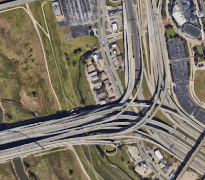
Arlington, TX: I-30 vs. SR-360
 |
| City of Arlington, TX - City Hall posted |
 |
| Satellite |
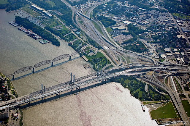
Louisville, KY: I-65 vs. I-64 vs. I-71
The estimated cost of the interchange, $600m, was almost twice the cost of the new bridge itself, $340m. [Bridges and Tunnels]
 |
| Interchange ,USA🇺🇸 For Engineering information visit 👉👉https://bit.ly/2CK0pBf Lee Stephens: Known as Spaghetti Junction! Where I- 65 I-64 and I- 71 converge in Downtown Louisville, KY USA. I just call it gridlock! Christopher Boden: Why do some sections of road fork off then join the same bit of road again? Kevin Fransen: Christopher Boden are you referring to the freeway going from the top left to the middle rightin the photo? That is Interstate 65. You’ll notice that there are barricades dividing the lanes.Taking the left 2 lanes will keep you on I-65 South. Taking the right lane will allow you to exit onto surface streets. There is an entrance back onto I-65 Southbound though. That is because those lanes are used for Eastbound/Westbound I-64 drivers who want to go South on I-65. |
When I-65 was built, the John F. Kennedy Memorial Bridge was opened in 1963 to carry that Interstate across the Ohio River. The Abraham Lincoln Bridge was added in 2015 to help relieve the congestion. A big part of that 2015 project was building a new interchange on the south side of the bridges. They had to build the new interchange while maintaining traffic flow through the interchange. I had the "thrill" of driving through that intersection during construction. You had to read the signs fast and be prepared for being jammed into another lane. And each time I went through it, the maze was different. Hopefully it now has proper merge lanes so that the traffic is not jammed together. This construction caused tolls to be added to the I-65 bridges.
 |
| Google Earth, May 2022 |
Here is a "before" image:
 |
| Google Earth, Aug 2010 |
 |
| CossGamer posted [The description sounds like AI generated platitudes.] Heath Blandford: That map has an error. Has Bloomington positioned where Evansville is. |
Using a road map to get the big picture, we see that I-64 is an east/west highway and I-65 is a north/south highway. I-71 starts at this intersection and goes towards Cincinnati.
 |
| Road Map |
 |
| Sep 21, 2016, source: Kentucky Transportation Cabinet via Bridges and Tunnels |
 |
| stantec |
Albuquerque, NM
 |
Highway Engineering Discoveries posted Big I Interchange Albuquerque, New Mexico |
 |
| Satellite |
 |
| Putera Raja Ahmad Syairozi commented on the above post Meanwhile in Highway in Malaysia |
Huangjuewan Junction in Chongqing China
 |
| Nickey.com posted China’s |
While looking for the above, I found the following. Or is this what the locals call the "Spaghetti Junction?"
Note that the road to the East goes into a tunnel.
 |
| Satellite |
 |
| Highway Engineering Discoveries posted Pontus Mirar Hagland: https://www.google.com/.../data=!3m1!1e3!4m6!3m5... |
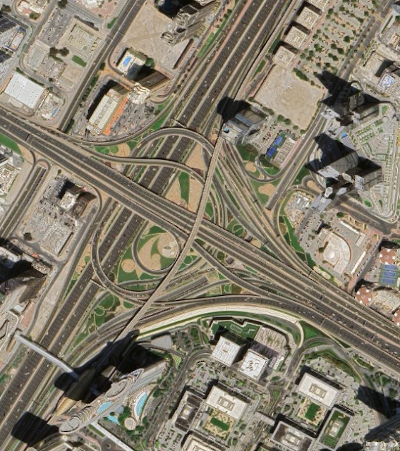
Dubai, UAE
 |
| Highway Engineering Discoveries posted Dubai 🇦🇪,United Arab Emirates... Nickey.com posted https://nickeyscircle.com/dubais-massive-interchange/ |
 |
| Dennis DeBruler commented on the above post https://www.google.com/.../data=!3m1!1e3!4m6!3m5... |
Is this the same intersection without the landcaping?
 |
Highway Engineering Discoveries posted Dubai |
How many of these interchanges do they have. Some of them have rather sparse traffic.
 |
| Highway Engineering Discoveries posted Dubai... United Arab Emirates |
 |
| Highway Engineering Discoveries posted Dubai |
Gravelly Hill, Birmingham, UK
 |
Highway Engineering Discoveries posted United Kindom David Moth: Gravelly Hill, Birmingham? |
 |
Dennis DeBruler commented on David's comment Thanks for the information. The UK is a big place. |
Guangzhou, China
I spent more time looking for this. I thought an intersection with five "spokes" would be easy to find. I found a lot of flyovers in Guangzhou, but not this one.
 |
| Highway Engineering Discoveries posted Aerial View of flyover in Guangzhou City, China |
Chicagoland
It's not spaghetti, but it is a nice photo. The local and express lanes of I-90 leaves the Dan Ryan, then the Dan Ryan interchanges with I-55, then it terminates at Cermak, Ave.
 |
| We Love USA posted Chicago, Illinois |
I'm saving I-88 vs. I-294 vs. Roosevelt Road because the Toll Road is building a new interchange design, again.
 |
| Satellite |
Dallas
 |
Highway Engineering Discoveries posted Dallas Texas, USA Bryan Hunt: Sergio Garcia Downtown Dallas. Upper right is I30 coming in from Grand Prairie and it's connecting to I35E. James Stark: Concrete contractors must be fat & happy with Dallas/Fort Worth; Dallas seems to have more “flyover ramps” than any other place here in the USA; It concerns me that (in my 18 wheeler) there is only the low K barrier to keep me from “flying” off down into oblivion; I did see an 18 rig hanging off up high of one spilling its entire tractor diesel tank capacity one day; There are plenty of these concrete flyovers in Houston, Austin, San Antonio & El Paso too… [These roads look almost as sparse as the roads in China.] Highway Engineering Discoveries posted Spaghetti Interchanges Jim K. Georges: Dallas Texas I-35E @ I-30 |
 |
| Satellite |
And that is just the western part of the intersection. Here is the whole thing.
 |
| Satellite |
This is the Dallas Horseshoe, which was built in the 2010s.
 |
| wsp |
There is a lot of spaghetti in Dallas. Where is this one?
 |
| Highway Engineering Discoveries posted High Five Interchange Dallas Texas, USA |
 |
| Jason Manopoly posted Dallas, Texas in USA [I do not understand why people won't provide the route identifiers for the roads in an intersection.] |
 |
Highway Engineering Discoveries posted |
Finally, a post with location information. And this post identifies the above post.
 |
| Highway Engineering Discoveries posted The High Five Interchange is one of the first five-level stack interchanges built in Dallas, Texas. Located at the junction of the Lyndon B. Johnson Freeway (Interstate 635, I-635) and the Central Expressway (US Highway 75, US 75), it replaces an antiquated combination interchange constructed in the 1960s. |
 |
| 13:17 video @ 0:10 |
Shanghai, China
 |
| Sunay Das posted SHANGHAI .... CHINA .... [I noticed the stadium on the left side. So I searched for "stadium" in Google Maps and looked for a stadium icon near a road intersection. I found this and this. But neither match the photo.] |
 |
| Sunay Das posted ONE OF THE BUSIEST OVERPASS IN THE WORLD .... LOCATED IN SHANGHAI .... CHINA .... 陳加戲: This is a real landscape, not fake. Shanghai Yan'an West Road Overpass [Even with the clue, I could not find it.] |
Unknown
 |
Highway Engineering Discoveries posted [A lot of comments called this a good design. My reaction is that it is a bad design because to make a "left turn," you have to cross three lanes in less than a quarter of a circle. Some comments point out that if you miss your exit you can go around it catch it again. I think it is better to simply have a flyover ramp that makes the left turn without having to look for another exit. This design is better if a lot of people have to make a U-turn, but I don't understand why a lot of U-turns would be needed.] |
 |
| Highway Engineering Discoveries posted Chinese Highway [This reminds me of the mountain interchange in Japan.] |
 |
| Highway Engineering Discoveries posted China |
 |
Highway Engineering Discoveries posted Highway interchange in China |
 |
| Highway Engineering Discoveries posted Highway intersection [Wow, this time he didn't even bother to specify a country.] |

Fantastic engineering. Thank you for shearing.
ReplyDelete