Saturday, December 20, 2014

Missing Red Light at End of Trains (FRED, ETD, EOT)

<updates>

All of these pictures I took below were during the day. I need to look after dark even though I can't take pictures then. The devices light up only at night to save battery power. Reflective material that catches the locomotives headlight provides daytime warning. [Trains]

They are supposed to flash during the day if the brakes are applied. UP introduced EOTs in 1984.

The End-of-Train Device (ETD) transmits brake line air pressure and direction of movement every 40 seconds. "If there is a loss of radio continuity between the ETD and the cab, this will be displayed." A modern ETD is also required to receive a command to apply emergency braking (dump the air). [Trains] But the article doesn't say if a "hello" command is sent every 40 seconds from the front to the back so that the ETD can report the loss of communication to the ETD. We called a periodic "can you hear me now?" message the "heartbeat" protocol, and it was standard practice when designing communication protocols between computers.

They were originally called rear-end-devices. But workers added an adjective that expressed their displeasure with loosing the caboose thus giving us the acronym FRED. That adjective has since been sanitized as "flashing." Other acronyms this brings to mind is FUBAR (fouled up beyond all recognition) and RTFM (read the fine manual). I understand that FUBAR was invented by the military. I don't know which profession popularized RTFM, but it certainly applied to my profession of computer science. Actually, there were days when FUBAR was rather appropriate also. We had a saying: "it takes a computer to really mess things up."

</updates>

Richard Cramer commented on a post:
The one thing I can add to the reason these cabooses were back there is they did save lives. And the elimination of them actually cost lives when they first used “FRED”. Those deaths caused a complete elimination of those first edition end of train devices.
In the railroads hast to eliminate the cabooses with FRED, they forgot one major safety device that was eliminated with the implementation of FRED. The emergency brake valve that was on all cabooses for a reason. That small detail was overlooked and trains that had an ice blockage in the train line coming down the mountain had the great result of a RUNAWAY TRAIN with only brakes applies back to the ice blockage !
So those deaths caused the FRA to redesign the telemetry of FRED. FRED became a two way telemetry system, where the engineer could dump the air brakes from a button on the control console of the locomotive and it would send a radio signal to FRED and it would open a valve and the train could be put into emergency from the rear end.
This became part of the A6 initial terminal air brake test required by the FRA before any train could leave their initial terminal.
It was called the “dump test”.

20141011 0304
When a mixed freight train that was parked in Downers Grove started moving, I noticed the End-of-Train device did not have a red light.


To try to prove it did not have a blinking light, I took several pictures. And almost every picture lined up with a pole in the commuter fence so I had a hard time finding a clear shot of the End-of-Train Device (EOT or ETD). But multiple pictures still don't "prove" that a light did not blink on. So I took some video. The videos are boring and not worth posting so take my word for it -- there is no blinking red light.

I remember seeing red lights when they first replaced cabooses with EOTs. The red light indicated the end of a train like the marker lamps on a caboose.

Library of Congress: Chicago, Illinois. Rear brakeman hanging out signal lamps on the caboose before a Chicago and Northwestern Railroad train pulls out
20141013 0145
20141017 0196
So I made a point of looking at the end of trains. None of them had a red light, blinking or steady. CN/IC on the left. On the right is a switching move in Mendota, IL. Below are views of the end of an IHB train.
20141025 0098


The photo to the right is at camera resolution.


Some trains have a red flag instead of an EOT. I saw one on the end of a BNSF/CB&Q train that was being switched in Mendota and on an IHB train near the Burnham Ave. overpass. It seems if a train is going to go slow and the trip is short then it needs only a red flag.

Scott Griffith posted
FIRST EOT to arrive at BARR YARD

Bill Molony posted
Sorry, but I don't have a date or location for this photo.
Mick Swanson Totally novice here... what were cabooses used for?
Dennis DeBruler You have to imagine what railroading was like before diesel locomotives, radios, computers and dynamic brakes. Trains had a five person crew. The engineer, fireman, and head brakeman rode in the locomotive. (Although sometimes the head brakeman rode in a little shack at the rear of the tender.) The rear brakeman and conductor rode in the caboose. Without computers, the conductor used the caboose as an office because he had to process waybills. The brakemen ran on top of the freight cars setting and releasing the handbrakes. Even after air brakes were developed, the brakemen would have to partially set the handbrakes in mountains before going down a long descent. The crew in the back also monitored the air pressure in the airline. An EOT (End of Train) device used radio to allow the engineer to read the airline pressure at the end of the train. Going back in time before trackside signals were developed, if the train stopped, the rear brakeman would also have to grab a lantern and run a long distance behind the train to warn any oncoming train that there was a problem ahead. Of course, the fireman was busy monitoring the water level and stoker on a steam locomotive. In short, a train really did need a five man crew until about the middle of the 20th Century with two of them riding in the back.
EOT: https://industrialscenery.blogspot.com/.../missing-red...
Running Boards: https://industrialscenery.blogspot.com/.../missing-red...
Douglas B. Carlyle Mick Swanson great summary.
Jeff Lackman: Way bills were the instructions of where the cars in the train were being sent to or picked up from. In the day some trains made many stops to deliver and pick up freight cars from smaller factories and businesses than would be typical today (much of our freight now moves in containers and truck trailers which are moved in huge trains by railroads that deliver them at huge yards built just to handle trailers and containers).

Keith Hoy posted three photos with the comment: "RAILROADING. Now days on the end of trains there is a device called flashing rear end device, they call it FRED, or an engine called distributed power or pusher. I still miss the caboose."
Everett Lueck: Most of the trainmen don't miss it. I think that the caboose was responsible for the largest percentage of injuries on the railroad over all. Nothing like being in one when the slack runs in or out, and you are not in the right place to be prepared for it. [And today's longer trains would probably make the slack action even worse.]
Jim Polaski: I thought they were called "EOT's"?
Dennis DeBruler shared
1

2

3


Wednesday, December 17, 2014

CGB Shortline Railroad and an EMD GP9 Locomotive

Update: The IlliniRail specifies:
OLNEY           CONTINENTAL GRAIN & BARGE  GP9 6140; ex-H.N.V. Central Riverfront 6140, nee-C&O 6140  (22048, 5467-32 /56),


20141211 0193c
The grain elevator in Olney, IL, has its own locomotive. R. Craig has identified it as a GP9 built in 9/1956 originally as Chesapeake & Ohio 6140 with serial number 22048. Dave Honan posted the following info from Ken Ardinger.

  • Built as C&O 6140 in 09/56
  • It went to dealer Wilson in Des Moines, IA & was painted dark blue with large white lettering for H.N.V. Central Riverfront, sent to N. St. Louis in 08/87
  • At CG&B in Clarksville, IN, in late '91, Jeffersonville, IN, in 06/93 and 07/95, and Olney, IL, in 10/95 

20150104 0101

When I first arrived at the elevator on my Dec 11 trip, it was behind the string of cars you see on the former Illinois Central through track. Every few minutes 6140 would fire up and move its cars a few more feet. By the time I was done taking pictures of the elevator, it had become visible on the track side

Satellite
The elevator not only has its own locomotive, I think it owns its own industrial spur. It uses a remnant of the PD&E route of the Illinois Central. The satellite image to the right shows the entire railroad. It is the white stripe just left of center with a siding down near the bottom next to the grain elevator.

Satellite
Zooming in near the top of the railroad, we see the diamond for the original CN/IC branch that went north/south has been removed but that the interchange lead to CSXT/B&O in the southeast quadrant has been retained.


The south side of the railroad now terminates just before S. White Ave. They recently tore up the track that went across this road to Co Rd 900 N. Of Google, Bing, and MapQuest maps, Google is most accurate. It shows the track terminated near Co Rd 900 N. The other maps show it going all the way to Evansville even though most of that track was abandoned years ago. Note that the remaining track is straight and the ballast is fresh. That was true for the full length of the spur.

Even the most accurate map, Google, shows a track in the southwest quadrant of the IC/B&O intersection, but the satellite map indicates that it no longer exists.  And even though Google normally shows each of the tracks at high resolution, the map shows only one track for this spur. But most of the length of the spur int the satellite view has at least two tracks. And some of the length has three tracks. The photos I took indicate the satellite map is current.

I tried checking the CSX system map, but it was broke (Dec. 16, 2014). It displayed just a light-blue box.

http://www.acwr.com
Then I found an interactive map for CSX and zoomed in to enough detail to show sidings. But it doesn't show the spur to CGB. However, I could not find CGB listed in a list of Illinois shortlines. So I still don't know who owns this segment. As noted, whoever now owns the track has been maintaining it. On the Dec. 11 trip, I followed White Ave. north until I crossed the CSX/B&O tracks. I discovered there were a lot more modern looking covered hoppers parked along the length of the spur. More on that later. I also discovered that there were three CSXT engines on the interchange leg, so I switched to my telephoto lens so that I could take a picture of them from North Street (see below). Note that I was fighting the availability of sun during a short winter day. I could see that the number for the first unit was 5368. Fortunately, I was able to catch views of the other two units from South Street (see further below). The CSXT engines are 5368 (ES40DC), 110 (AC44AH) and 8060 (SD40-2). You could hear that at least one of the engines was idling. And while I was taking pictures, I heard an engine pump up its air. Are these engines going to idle the entire time it takes to fill up all of the hoppers?


And looking south from South Street we see the top of the CGB grain elevator in the background and the northern most hoppers that were parked on the spur.


While working my way south to take pictures of the hoppers, I came across this old Ford tractor pulling another old tractor out of a garage. The name plate indicates "Ferguson."


On the east side of a trailer park, I was able to confirm that all of the hoppers were uniformly modern. Unfortunately, I did not have enough camera resolution to read the builders plate.


But in the view on the right made from a crossing, I did have enough resolution to determine the built info was 12-10. So December 2010? I took pictures north and south from many of the crossings.  Looking at the pictures, I could determine there were 4+5 cars south of Glenwood Street, 6+6 cars between Glenwood and the southern industrial crossing, and 3 cars between the industrial crossings. Since there are two hoppers parked in the current satellite image, I could determine that a car is about 50 feet long. By measuring the distance from the northern industrial crossing and Lafayette Street, I estimate it was storing 6+20 cars. From the following telephoto picture from Glenwood Street and the photo down by the elevator, I estimate there were 16+14 cars down by the elevator.


So there were about 77 CSXT hoppers in town.

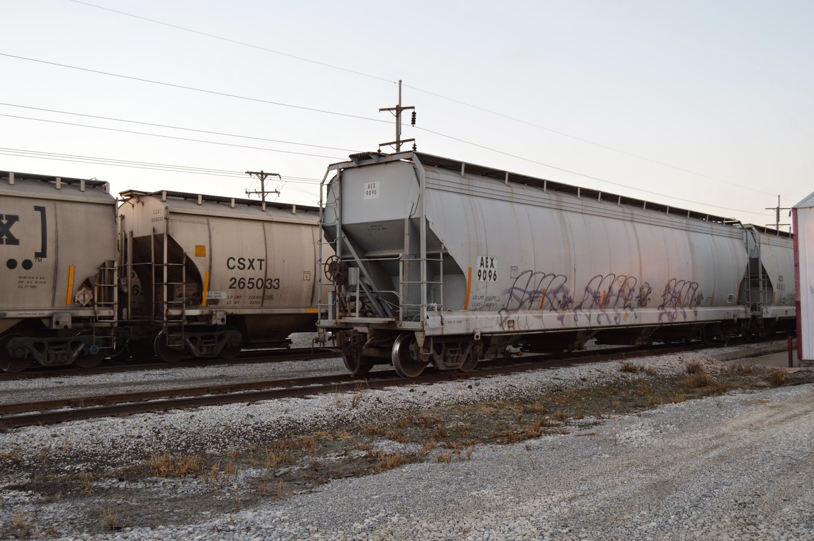
There were also 9 AEX hoppers on the siding that runs east of the two main tracks.


The elevator needs a string of empties on the west track. Then, as they become full, CGB 6410 shoves them up the east track. But there is not room on the east track to hold all the cars that are already there plus the cars that are on the west track. That must be why the CSXT engines are staying in Olney. I'm guessing that they move cars from the east track to the west track as the CGB switcher moves them from the west track to the east track. When all the hoppers are full, the CSXT engines pull the content of one track onto the mainline and then backs it up to collect the cars on the other track. I assume during these CSXT switching maneuvers, the elevator employees help flag the six crossings in town.

During my Nov. 8 trip, I saw another train being loaded.

Generating Plant Smoke Plumes (Duke/Gibson + Newton)

(More smoke plumes)

Duke Energy/Gibson Generating Plant


Update: the Big Four railroad bridge over the Wabash River is still used to supply this plant. My notes on the power plant itself


20141211 0181c
While driving west on IN-64 towards the Wabash River, I noticed a power plant plume. It appears that 3 or 4 of the units were operating. Later I passed a sign indicating it was Duke Energy. The Gibson Generating Station was originally owned by Public Service Indiana. It has 5 units generating 3,340 megawatts. It is the third-largest coal power plant in the world, and the largest still operating in North America.

Network Indiana
The 4 original stacks are 550 ft and the 2 newer stacks are 620 ft. No wonder they are easy to see over the treeline. Actually, the plant may be running at full capacity because two of the stacks are now derelicts left to nesting cliff birds such as the peregrin falcon or the bald eagle. That gets a "hidden nature neighborhood" award ("nature" label). In fact, south of the cooling lake is Cane Ridge National Wildlife Refuge, which serves as a nesting ground for the least tern, a rare bird. And they provide public access to the Wabash River on their land. In this day and age of fenced off and gated properties, that is good to hear. It is interesting that they built such a large cooling lake given its proximity to the Wabash River.

This is the largest power plant in Indiana.
From NIPSCO and pro-coal-bill

I believe the plume is dark because I was running out of daylight, not because of particulate emission. They finished adding selective catalytic reduction (SCR) units to reduce NOx emmisions in 2008. To keep the SCR catalyst clean and operational, it is now economically beneficial for the plant to remove fly ash. And their web page indicates that all five units have sulfur dioxide scrubbers. So they probably burn local southern Indiana coal rather than Wyoming Powder Basin coal. My Dad said that the Indiana coal burns hotter and that helps make it economical to run the sulfur scrubbing equipment. In contrast, most Illinois coal burning plants use Wyoming coal or natural gas. The Illinois coal is exported to China! The Gibson plant is now having to deal with high selenium levels in the cooling pond and the possibility of leaking boron into the water tables of the area (Wikipedia).

Looking at a map, the plant has industrial spurs to the former Southern Railroad to the north and the former Big Four to the south. The Southern Railroad is now part of the Norfolk Southern and is their mainline between St. Louis and Louisville. According to my 1928 Railroad Atlas, Big Four had a route from Danville, IL, to Mount Carmel where it forked just south of town and went to Cairo, IL, and Evansville, IN.
www.acwr.com
An NS map confirms that the Big Four remnants are now owned by NS. In particular, the segment from the former Southern route south to the fork and the initial part of the two forked branches are former Big Four trackage. The Evansville branch still has a bridge across the Wabash, but it ends at the power plant. The Cairo branch ends in a loop east of Keensburg.


The following satellite image indicates the loop serves some sort of mining operation. (Update: it was the Wabash Mine. This mine operated from 1970 to 2007 and supplied coal for the Gibson Plant.)
Satellite
The northern Wabash River bridge carries the St. Louis/Louisville traffic and makes economic sense. Note that there is a swing span on the west side with most of the west half of that span over land. A satellite image confirms this. But the southern bridge seems to support just the power plant. Thanks to an error in the Bing road map of terminating the line for the railroad too soon, I can determine that it has a swing span more towards the center of the river.
Satellite

Newton Power Plant


While driving north on IL-130 south of Newton, IL, I noticed another smoke plume off to the West. I have done this trip multiple times, but this is the first time I noticed a plume. I was aware of the Newton Power Plant near the north side of Newton Lake because I had studied a spur that runs south from a CN/IC route along IL-33. I noticed the "flat top" of the plume and kept my eye on it and took several pictures from IL-33 because I was running out of daylight, and I was hoping at least one of them would turn out. The last one I took turned out to be the best.

I'm sure the flat top is caused by layers of the atmosphere being at different temperatures. Probably an inversion of cold air on top of warm air. But why the boundary between the layers causes a ceiling for the plume is still a mystery to me.

Matthew Baltzell posted, cropped
Work’n the night shift baby.
Newton power station. Newton IL.
 
Dynergy
Unlike the Indiana plant, the owners of this 1,225 megawatt plant are still bellyaching about installing sulfur dioxide scrubbers so that it can use Illinois coal again. Ameren got an extension from 2012 to 2017 by holding jobs at other coal burning plants hostage (SourceWatch). Now Dynegy wants to buy this plant and four others in Illinois (Coffeen, Canton, Bartonville, and Joppa) but delay the clean up until 2020. And both companies refuse to consider an offer from a Illinois coal producing company to install the scrubbers. (WXEF, ChicagoBusiness) It is so nice to see the Indiana plant as an example that not all states are as screwed up as Illinois.


If NOx and sulfuric acid are not enough to worry about, I learned that you can also worry about toxic materials and chlorine gas. The page on chlorine gas makes me wonder about the risk of the Chicago Water Filtration plant that is right next to the Magnificent Mile and The Loop.


Monday, December 15, 2014

Santa Fe 9C Bridge and Canal Road

(Bridge Hunter, Historic Bridges, 3D Satellite)

The main purpose of this posting is to record a Facebook posting by Ramon Rhodes describing the BNSF/SantaFe bridge that crosses the Sanitary and Ship Canal in Forest View, IL.

Steven J. Brown posted
Santa Fe B40-8W's departing Chicago, Illinois - June 1991.
Jerry Jackson That isn't Lemont, but the Bridge close to I55 near Harlem ave, just out of Corwith

Glen Miller posted
Santa Fe Railroad Bridge over the Sanitary and Ship Canal, near Harlem Avenue, now owned by the BNSF Railroad, this swing bridge sits perhaps a quarter mile northeast of Harlem Avenue and still sees frequent traffic. The Historic American Buildings Survey Engineering Record dates it to 1899. All the moveable bridges over the canal are inoperable today with most of the machinery removed.
Paul Webb posted

Ramon Rhodes posted
One of Ramon's 15 photos shows the turntable and its foundation. The foundation is a reminder that part of the canal had to cut through dolostone down by Lemont so it was a very cheap construction material. In fact, it was waste material.
Photo by Wallace W. Abbey
ATSF, Chicago, Illinois, 1946
Santa Fe Railway passenger train "First 20," the first section of the eastbound Chief, comes across Bridge 9C east of McCook behind FT diesel no. 164 on July 28, 1946. Photograph by Wallace W. Abbey, © 2015, Center for Railroad Photography and Art. Abbey-02-062-03Dennis DeBruler shared [permanence of link is experimental]
This is the first photo I've seen where the old power line has wires. It was one of the first high-voltage lines in America, and I presume the world. The power line went from the powerhouse in Lockport to downtown Chicago and it was built by the sanitary district.
...See More

Ken Rehor commented on Dennis' share, cropped
 I spent many hours of my teen years on the other side of that bridge. I wish I would have seen Wally's photos back then. (Westbound Southwest Limited, Fall 1978)

Photo by Wallace W. Abbey
ATSF, Chicago, Illinois, 1946
Santa Fe's eastbound Chief passenger train, behind streamlined 4-6-4 steam locomotive no. 3460, crosses Bridge 9C east of McCook, Illinois, on its way into Chicago on April 20, 1946. Photograph by Wallace W. Abbey, © 2015, Center for Railroad Photography and Art. Abbey-01-047-01
Three more 1946 photos by Wallace W. Abbey by this bridge: streamlined steam locomotive, smoking passenger locomotive and freight steam locomotive

Bob Chaparro shared
Stan Jefferson: 84" drivers and 300# boiler. HUZZAH!!


I have done the trip down Canal Road but there is a tree line between the road and the canal that does not allow getting decent pictures of the bridge. Below are the best views I found of the bridge.

20140906 0134

 
The bad view was even more frustrating when a power move of 4 engines came through. I had the dumb luck that the numbers of the lead engine was behind a girder. This photo is at camera resolution. I'm pretty sure the last 3 digits are 547. But of course it is the first digit that is most important in determining the type/era of the engine. Since it has a "swish" paint scheme, I think the number is 7547, which makes it an ES44DC.  This consist of four locomotives had 3 different paint schemes.
As mentioned, the first locomotive had the "swish" logo. 5205 (C44-9W) and 7722 (ES44DC) had yellow block lettering and 1041 (C44-9W) had black block lettering.


Since the numbers for 1041 were blocked by leaves, I did have another shot that allowed me to determine that number.

Going further down Canal Road, there is an end-on shot of the bridge, and a clear view of the tracks. But the grade separation makes this another bad shot of the bridge.


So I tried a shot from standing on that little pile of ballast.

It is a decent end-on shot of the bridge, but I don't like end on shots. For example, it is hard to determine the truss type of a bridge. But you can clearly see that the top cord near the center truss are strictly tension members and that steel bridges need far less material for a tension member than for a compression member. (Combining the tensile strength of steel with the compression strength of concrete is why many bridges now use prestressed concrete rather than steel.)

Because it is hard to get pictures of this bridge, I was very relieved to see that Ramon has allowed me to cross this bridge off my todo list.

I also found three 1800s era power poles along Canal Road.

Update: I never knew it used to have four tracks until I read:
The only other swing bridge in Chicago is the Atchinson, Topeka, & Santa Fe Railroad Swing Bridge crossing the Sanitary Canal at West 46th Street. Also built by the Sanitary District and converted to a swing bridge by the U.S. Navy in 1942, it carried four tracks over the waterway. When built in 1899 there were very few cases where a single two-truss bridge carried four railways; normally a three-truss superstructure was employed. The bridge carried two tracks down the middle and a track cantilevered off each side of the bridge. The outside railway tracks have since been abandoned and removed from the bridge. This sturdy 1,346-ton bridge is designed to carry at least 4,200 lbs per linear foot over its entire length on each roadway (or about 700 tons per roadway). At just over 334-feet long and 54-feet wide the bridge was designed to safely support any combination of trains crossing the bridge at the same time. (Patrick McBriarty in ForgottenChicago. I have read his book and watched his DVD, but if he mentioned four tracks there, I forgot it.)


Luke Malin posted
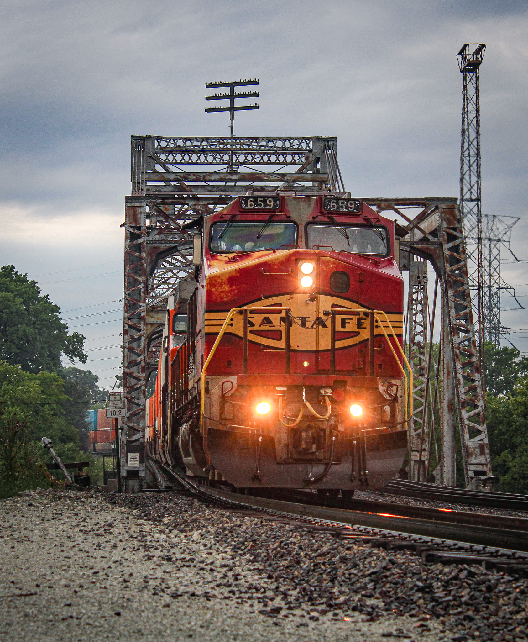
A shot I've been after for a while now that I was finally able to make a reality. Santa Fe 659 leads stacks over the 1899-built Chicago Sanitary & Ship Canal swing bridge in Forest View, IL. 
7/15/2022
Daniel Fredrickson: This engine suffered a catastrophic engine failure on the way back from Ohio this evening [July 17, 2022.]. The scrap yard is its next home.
From what I've heard so far it was a turbo failure leading to a major oil leak rather than the engine block. If that's the case there may be a sliver of hope, though I've seen locomotives trashed for less so I guess we'll have to see.
Tanner Wical: Blew a rod out of the engine block
[Railfans pay attention to the few BNSF locomotives that are still lettered for Santa Fe.]
Alex Lorenz: Beautiful shot! Is that bridge still operational?
Ramon Rhodes: Alex Lorenz The bridge has never been "operational." It does not have a motor to open it and never has. It once was able to be opened manually using cables and a winch, and was opened about six times during World War II. However, it is fixed in place and the rails across it are welded solid. All barges and towboats using the canal must fit under the closed bridges.
Dennis DeBruler: The formerly-movable railroad bridges from the BNSF/Santa Fe Bridge in Lemont to the Lake haven't moved since 1954 except for the South Branch Bridge (also known as Canal Street or Pennsy Bridge). The St. Lawrence Seaway is now used for big loads. I did catch a towboat from Houston, TX, that did not get the memo about the bridges. It was parked at the Lemont Bridge.
 https://industrialscenery.blogspot.com/.../houston-we...

Ramon Rhodes commented on Alex's comment
The tow boats that use the canal have pilot houses that are retractable. When they need to get under a bridge the pilot house is dropped down to the deck, and then as they come out the other side it is elevated back up again. It's on a hydraulic lift like you would see in your auto mechanics garage.
Jeff Lewis: Clever. I'm guessing the stairway is hinged and on a track so it moves backwards?
Dennis DeBruler: Jeff Lewis I believe so. If you look in these notes you can find closeups of Al Weaver with its pilothouse up and down. Unfortunately, I focused on getting a video of Sam M. Fleming going upbound and missed the pilothouse going down on Al Weaver. (Hindsight can be frustrating with tow fanning as well as railfanning.)
 https://dldreference.blogspot.com/.../20180708-sam-m...
There are more photos of towboats with retractable pilothouses in these notes.
 https://industrialscenery.blogspot.com/.../variable...