I used to think the .pdf copy was a better scan. But I have discovered that the eBook did a better job with photos. I include copies from both sources for a map so that you can judge which is better. I enlarged both images until they began to show pixels. The .pdf indicated 150%. I could not get a percentage for the eBook, but I would say it was also around 150%.
You probably need to click and image and then save to disk and use a photo viewer to access the full resolution stored by the blog server.
 |
| Digitized by Google, p531 |
 |
| pdf copy from 1915 Smoke Abatement Report, p531 |
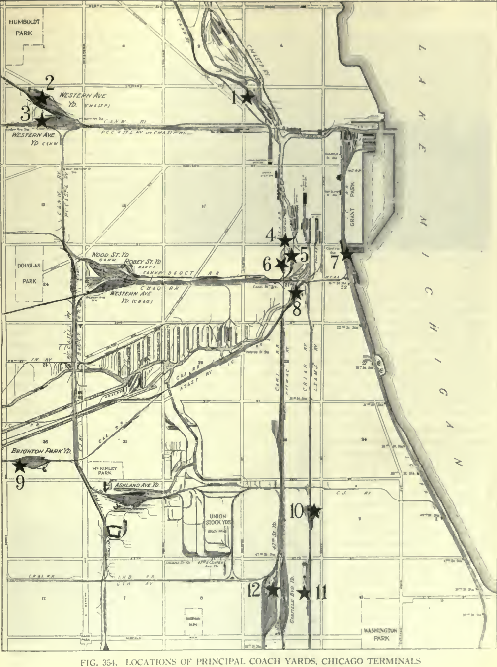
I could not find a key for this map in the report so I made my own:
- 1: C&NW: Erie Street Yard suburban
- 2: Milwaukee Western Ave. Yard
- 3: C&NW: California Yard intercity and suburban, now just suburban
- 4: Pennsy, today the land is used by Amtrak
- 5: B&OCT, Lincoln Street Yard was built after this map was drawn in 1915. [Bob Lalich comment on a post]
- 6: CB&Q, intercity and suburban, now just suburban
- 7: Illinois Central (IC, MC for a while, and Big Four)
- 8: Santa Fe
- 9: GM&O/Alton/Chicago & Alton Brighton Park Yard
- 10: NYC Root Street Yard
- 11: Rock Island 49th Street Yard
- 12: C&WI, which handled coaches for its five owners: Erie, Monon, GTW, Wabash, and C&EI
- way down south: NKP CalumetYard
 |
| Digitized by Google, p529 |
 |
| Digitized by Google, p530 |
 |
| Digitized by Google, p532 |
 |
| Digitized by Google, p533 |
 |
| Digitized by Google, p534 |
Until I write an overview of the freight houses in Chicago, I'm going to park this here.
 |
| William Brown posted, rotated I received the SFRH&MS,'s "the Warbonnet" Magazine today. It had a great article on the proposed replacement of La Salle Street Station, Dearborn and Grand Central Stations with a new Station. This map does a great of showing the Rock Island's downtown Chicago Facilities. The Chicago River Cross Dock and Elevator we're new for me. William Brown posted with the same comment William Brown posted with the same comment Ted Coffey: The center of the railroad universe until the automobile and trucking Christopher N. Kaufmann: Ted Coffey literally, and to think it was the vision of one 29-year-old man in 1835, William B Ogden, our first mayor. https://digital.lib.niu.edu/islandora/object/niu-lincoln%3A38239 |
 |
| Jon Roma commented on William's third post |
No comments:
Post a Comment