 |
| MWRD posted on Feb 21, 2022 A view to the northeast showing a portion of a bridge at Throop Street over the South Branch of the Chicago River in Chicago, Illinois, on April 17, 1902. Construction of the bridge began in 1901 and was completed in 1903. MWRD posted again with the same comment |
 |
| MWRD posted on Sep 22, 2022 A view to the northwest at the southeast leaf for a bridge at Throop Street over the South Branch of the Chicago River in Chicago on April 24, 1902. MWRD posted |
 |
| MWRD posted A view to the southwest of the southeast abutment for a bridge at Throop St over the South Branch of the Chicago River in Chicago on November 8, 1901. Construction of the bridge began in 1901 and was complete in 1903. Bridges Now and Then posted with the same comment MWRD posted again |
 |
| MWRD posted A view to the east showing the southeast abutment for a bridge at Throop Street over the South Branch of the Chicago River in Chicago, Illinois, on November 8, 1901. Construction of the bridge began in 1901 and was completed in 1903. MWRD posted |
 |
| MWRD posted A view to the east showing work on the southeast abutment for a bridge at Throop Street over the South Branch of the Chicago River in Chicago on September 13, 1901. Construction of the bridge began in 1901 and was completed in 1903. MWRD posted on May 15, 2023 |
 |
| MWRD posted A view to the northeast showing work on the southeast leaf for a bridge at Throop Street over the South Branch of the Chicago River on March 27, 1902. |
Loomis Bridge
 |
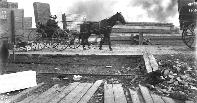
| MWRD posted A view to the east showing conditions of the northern approach to the Loomis Street bridge over the South Branch of the Chicago River on November 13, 1902. [Note the piles of lumber in the background.] MWRD posted MWRD posted |
 |
| MWRD posted Construction of a bridge at Loomis Street over the South Branch of the Chicago River on March 8, 1904. |
 |
| MWRD posted on Dec 8, 2022 Construction of a bridge at Loomis Street over the South Branch of the Chicago River on May 10, 1904. |
 |
| MWRD posted on Oct 3, 2022 Construction of a bridge at Loomis Street over the South Branch of the Chicago River on May 20, 1904. |
 |
| MWRD posted Construction of a bridge at Loomis Street over the South Branch of the Chicago River on May 20, 1904. |
 |
| MWRD posted Lumber yards along Loomis Street viewed to the north from the bridge over the South Branch of the Chicago River on November 13, 1902. |
 |
| MWRD posted on Mar 14, 2023 [Facebook broke before I could copy the comment.] |
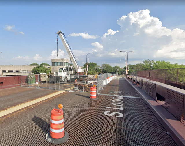
I don't have any photos of this bridge because it is surrounded by industrial property so I could not get any views that Street View could not get. Chicago does a better job of maintaining their truss bridges than Illinois does. This photo caught the first phase of a reconstruction of the bridge. [CDOT]
 |
| Street View, Jul 2019 |
A satellite view caught a barge under the bridge holding a worker lift so they were doing even more maintenance.
 |
| 3D Satellite |
 |
| transmartinc They replaced the steel members of the deck as well as the deck slab. |
A closeup showing the bridge is bolted rather than riveted.
 |
| Street View |
I saved this 2009 photo because smoke is coming out of Fisk's smokestack. That means it was still running in 2009. Also, I wanted to save a link to this page because it offers photos of the Canal Origins Park before it was overgrown.
 |
| mapio |
Before 1904 there was a swing bridge. Note the smoke stacks of the Fisk Generating Station and a gas-o-meter in the left background. Historic Bridges says this bridge "was a 200 foot long 30 foot wide hand-turned iron swing bridge built in 1889 by Shailer and Schniglau."
 |
| [Whoops, I forgot to record the source. Sorry] |
 |
| MWRD posted Historical photo of the week: Lumber yards along Loomis St., viewed to the north from the bridge over the South Branch of the Chicago River on November 13, 1902. |
The 1904 date in Bridge Hunter would be for the Scherzer rolling lift bridge that existed between the swing and trunnion bridges.
 |
| Historic Bridges, the page has additional photos of the rolling bridge. Former Loomis Street Bridge Source: scherzer Rolling Lift Bridges, 1908 Digitized By Google |
 |
| Copelin Commercial Photographers, James S. Parker and Chicago Photography (University of Illinois at Chicago) Via BridgeHunterOld |


Dennis, have you been able to determine when the Throop St. bridge went out of service, and was not replaced?
ReplyDeleteI query because the aforementioned bridge was one which had a City authorized streetcar through route [#23 - Morgan-Racine-Sangamon] operating thereupon. The route, astonishingly, had some operation on private right-of-way (which I endeavored to shoot six years ago - ask about the photographs).
Do you have access to a scanner? I have a AAA map from 1995 which strove to include all the freight railroad stubs in the metropolitan Chicago area, including those which I know are now gone [Cermak Rd.]. As such, these may be more accurate than the maps upon which you are relying upon. Please contact me.
When the Throop bridge was lost is a question that is also on my mind. My current email address is dennisdebruler2@gmail.com
Delete