At the Falls on the Ohio, the river bed falls 26 feet in three miles. I didn't realize until I saw the following photo that there was actually a falls here. I thought it was a rapids. It turns out, it is both. In addition to a falls, it had three rapids called chutes. From north to south there was the Indian, Middle and Kentucky Chutes. The Indian name got changed to Indiana by the 1890s.
 |
| Canal Society of Indiana posted The Ohio River forms the lower border of Indiana and flows from Pittsburgh PA to the Mississippi river near Cairo, IL. It was free flowing except for a 2 mile stretch near Louisville, KY where it makes a 22 foot drop over a limestone ledge. There were 3 chutes through the rapids at the “Falls of the Ohio”. The “Indiana Chute” was the widest and closest to the Indiana shore. Here flatboats had to decide to hire a pitot to shoot the falls or transport their cargo 2 miles around the falls on the Kentucky side of the river. |
 |
| Canal Society of Indiana posted The falls at Louisville only allowed a one-way trip downriver as no boats could be taken up river. This was fine at the time for flatboats carrying settlers moving west and goods for New Orleans. The first steamboat, the New Orleans, arrived on the Ohio River in 1811. A new era demanded a bypass canal. On which side of the Ohio River would this canal be built? |
 |
| Canal Society of Indiana posted Indiana organized canal companies 3 times to build a 2.75 mile canal from Jeffersonville to just below the falls. The first attempt was in 1805 when Indiana was just a territory. After Statehood in 1816 another company called the Ohio Canal Company was chartered and this effort was also supported by Cincinnati merchants. Funding faltered and no construction was performed. The third attempt was the organization of the Jefferson Ohio Canal Company. Ground was broken on May 4, 1818 and some dirt moved. A lottery was held in 1819 to raise funds but, like the canal, was a failure. In 1825 Kentucky formed The Louisville & Portland Canal Company. With federal support the bypass canal was completed in 1831 at a cost of about $1 million. With several later improvements, this canal still operates today. See indcanal.org - March 2019 The Tumble & Historical Archives - Tour Guides |
The 1831 canal had four flights of locks at its downstream end. But it had competition from the chutes. As with the St. Lawrence River, the canal was used going upbound, but boats would continue to use the rapids when going downbound if the water was high enough.
 |
| louisville.edu, p48 |
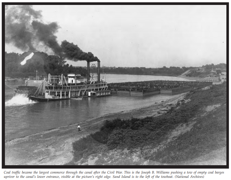
Cincinnati’s marine designers began to adjust to the canal’s dimensions, building steamboats that were 185 feet long by 43 feet beam, filling the lock chambers to near capacity. To offset the dimensional limits, steamboats loaded with freight to a depth of nine feet used all the water in the canal by crabbing, or pulling through the canal backwards, their paddlewheels dragging them across the mud flats on the bottom. It might take them an entire day to get through the canal in that fashion, but it allowed continuing on to New Orleans or St. Louis without transshipment. [louisville.edu, p82]
 |
| Peter Zimmerman posted The Ohio River circa 1906. Canal locks at Louisville, Kentucky. 8x10 inch dry plate glass negative, Detroit Publishing Company. (unknown photographer) James E Reising: The TRANSIT was a local harbor tug, she caught a lot of the Howard launchings, brought a lot of logs to the shipyard from the log raft storage area behind 6 Mile Island. She also worked for the Combine shuttling loads between the Pumpkin Patch fleet, just below 6 Mile Island, to the White City fleet, where Chickasaw Park is today, during low water periods. Looks like that's what she doing in this photo.[Note the original 1886 Kentucky & Indiana Bridge in the background.] Good Old Days posted Canal locks at Louisville, Kentucky on the Ohio River. c.1906. Lloyd Scott Hardin shared James Stark: Down bound towards the “singing” highway/railroad bridge with swingspan… |
 |
| 1886 Bridge, Public Domain, from Bridge Hunter Old via Dennis DeBruler Dennis DeBruler commented on James' comment Since what I saw over the navigation channel was a suspended cantilever span rather than a swingspan, I checked out the bridge. Does this mean that the bigger steamboats had to use the rapids to go upstream as well as downstream? The photo is Public Domain. James Stark: Dennis DeBruler Only if the river stage was high enough would they shoot the falls; Steamboats lowered their stacks when necessary… Dennis DeBruler: Thanks. I forgot that the smokestacks were hinged. |
 |
| booklet, p4 ca 1900 |
 |
| Richard Sattich posted Tarascon steamboat in the Louisville & Portland Canal. 1904. ... The "Tarascon," built in 1863 for the Louisville and Henderson Mail Line, was used in service during the Civil War. Here the boat sits at the Louisville & Portland Canal waiting for the locks to open. It traveled as far as the Alabama River and Mobile, before returning to the Ohio River. Caption under the photo reads, "Leaving Locks. Jeff Noble: Tarascon is one of the oldest family names in Louisville, or more specifically in Shippingport, which at one time was its own town, incorporated in 1785, on the land which is now cut off from Louisville by the Portland Canal. The Tarascons and others arrived there in 1806, predating the canal, and renamed the town of Campbelltown as Shippingport. They had previously purchased the site in 1803. They were shipbuilders and later operated a flour mill. Shippingport was a residential area until well after the 1937 flood. Eventually the entire area was bought by the Corps of Engineers in the late 1950s and the final residents either left or became deceased by 1964. Lloyd Scott Hardin posted Frank X Prudent: The TARASCON are in the photo is a later boat. The 1863 TARASCON was a sidewheeler. Doug Crawford: Frank X Prudent yeah I was gonna say that’s an incredibly long lifespan for a wooden Ohio river steam boat. |
 |
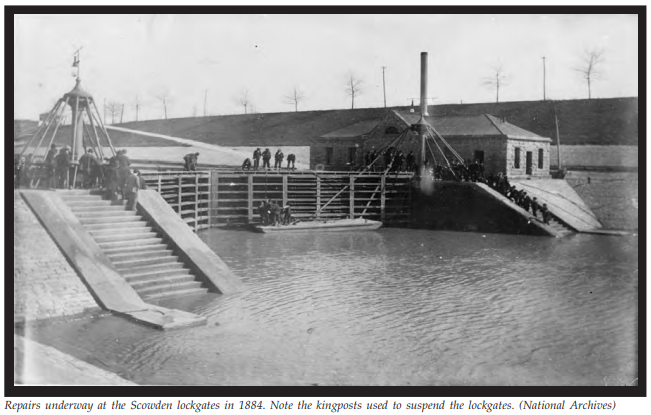
| Dennis DeBruler posted Logical page 138 and PDF page 150 in TRIUMPH AT THE FALLS: THE LOUISVILLE AND PORTLAND CANAL |
 |
| Comments on DeBruler's post |
In the 1870s, a crest dam was built to maintain a depth of 6' in the Louisville docks and at the head of the canal during low water. In the 1900s it built a new dam to maintain a 9' depth to accommodate tows carrying coal. This dam used the recently developed Portland cement instead of stone masonry for the foundation. Concrete was also used in the fixed weirs. Some of the dam was Boule trestles. The segment at the head of the Indian Chute used Chanoine wickets "that could be raised
or lowered faster than the Boule sections." [USACE, p210] Frequently, during the dry season, work was done to widen (by blowing away rock) and channelize (by building dikes) the Indian Chute until it achieved a width of 400'. [USACE, p214]
 |
| USACE, p194 |
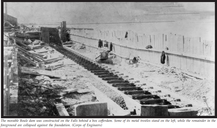
Reducing the flow in the spillway of the Boule Dam in 1930. They hinge a frame up and then insert a panel ("metal shutter"). [booklet, p7] Boule was the type of wicket dam design. Part of the crest dam above the Middle Chute was replaced in 1879 as an experiment. It was considered a success. [USACE, p171] The Boule dam shown here was in the 1920s dam at the head of the Indian Chute.


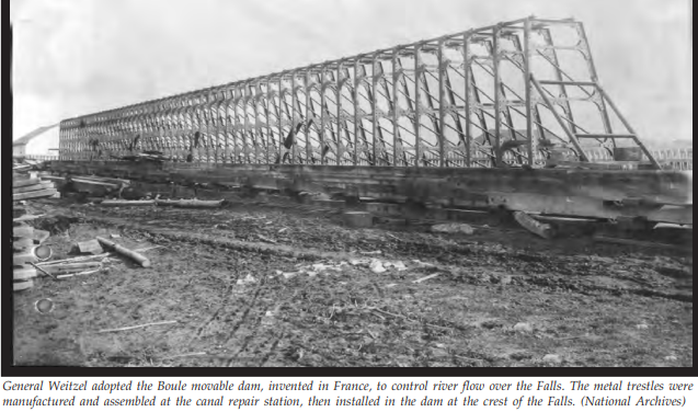 |
| USACE, p171 [(This page is also the beginning of the INDIAN CHUTE EXPERIMENTS. The original name was lost by 1890, and it became known as the Indiana Chute. [USACE, p193])] |
 |
| USACE, p180 |
 |
| USACE, p146 |
 |
| Richard Sattich posted Canal locks, Louisville, Ky. 1906. ... Locks on the Ohio River at Louisville, looking down the canal from the river bank. There are no boats visible in the locks; the gates are closed. Many structures are visible along the bank on the opposite side of the canal. Published by Detroit Publishing Co.; bears manufacturer's number 10431. Stephen Saalman: Much of the stone to build the locks came from the Cannelton, Indiana rock quarries. Lloyd Scott Hardin shared Michael Gore: Great look back. The view is actually looking up (not down) the canal. |
 |
| USACE, p146 They were repairing damage caused by the 1883 flood. |
 |
| USACE, p189 [K&I Bridge] |
In 1910, Congress passed a bill that approved a 53 lock & movable dam plan to canalize the river with a minimum depth of 9'. In that plan, the new dam built here would be #41. The plan called for an 85'x600' lock even though all of the other locks would be 600'x110'. The width of the lock was changed to 110' and the width of the canal was changed from 170' to 200' so that standard tows could pass each other without one of them having to duck into a passing basin. [USACE, p214] William McAlpine was in charge of the design and construction of the 600'x110' lock,
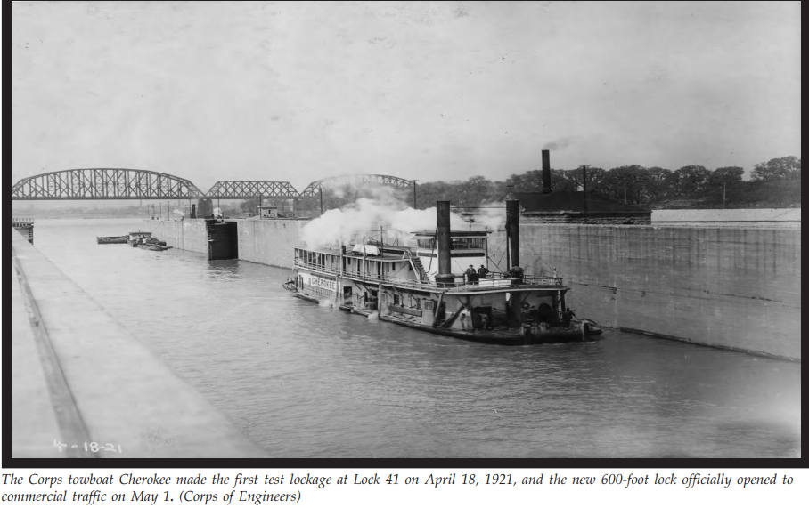 |
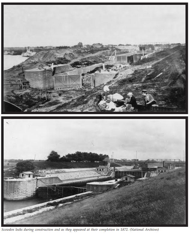
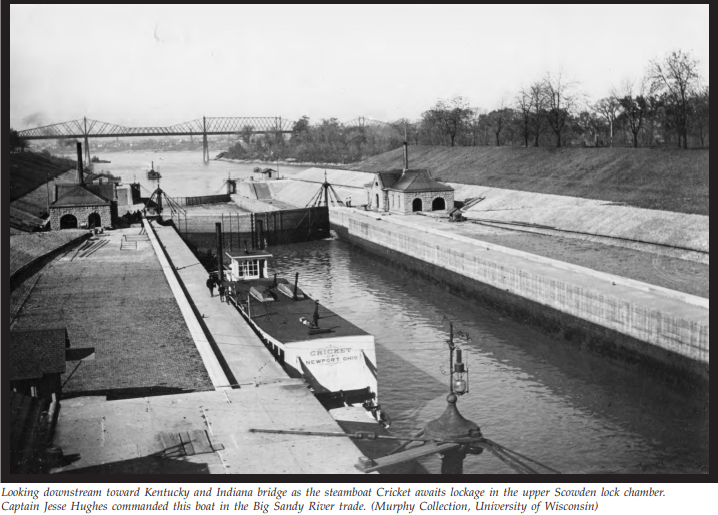
| USACE, p221 "Built of concrete and steel, integral to comprehensive plans for developing the entire Ohio River, Lock 41 set the pattern for twentieth century waterways engineering. The 1830 locks and fifty-foot-wide canal had served as the principal navigation structure bypassing the Falls for forty-two years until the completion of Scowden locks in 1872. In the second phase, Scowden locks and the eighty-six-foot wide canal served for forty-nine years until 1921. Although the epitome of engineering when built, Lock 41 and the 200-foot-wide canal were to serve as the principle structures in the third phase during the forty years from 1921 to 1961, when riverborne commerce expanded to volumes far exceeding the maximum predicted by the Lockwood Board in 1908 when it justified the canalization project." |
Because WWI caused the price of coal to go up and because the ice storm of 1918 heavily damaged the existing crest dam, William McAlpine advocated building a new dam that was 8' higher than the damaged dam. This extra pool height would eliminate the need for dam #40 and would provide more head for hydroelectric power. [USACE, p227] A public-private partnership was formed similar to the one that was pioneered by the 1913 Hales Bar Dam. The L-shaped dam that we see today was adopted to deliver the full 37' head to the powerplant built between Rock Island and Shippingport.
The lock walls did have to be raised and the lock gates had to be replaced with longer gates. [USACE, p231]
 |
| USACE, p229 |
 |
| louisville.edu, p154 |
 |
| David Gulden posted PEAVYS FREDERICK B WELLS by the portland canal now the AMY FRANCIS for MMT |
As part of the 1960s initiated effort to replace most of the wicket dams on the Ohio River with gated concrete dams, a 1200'x110' lock was added in 1961 and the canal was widened from 200' to 500'. The name of the complex was changed from Lock and Dam 41 to McAlpine Locks and Dam. The wicket controlled short part of the L dam was replaced with Tainter gates. That meant that tows could no longer use the Indian Chute. All river navigation had to pass through the canal and locks.
For information about the second 1200'x110' lock that was finished in 2009, see McAlpine Locks. For more information about the dam and the fossil coral reef it protects, see McAlpine Dam. I still need to write some notes about the powerhouse.
No comments:
Post a Comment