Power House: (Satellite)
The powerhouse is further downstream along the Caney Fork River. It is below some rapids, and it is fed by the Collins River. Being downstream of the rapids increases the head of the powerhouse.
 |
| TenneseeRiverValleyGeotourism |
The powerhouse is further downstream along the Caney Fork River. It is below some rapids, and it is fed by the Collins River. Being downstream of the rapids increases the head of the powerhouse.
 |
| Trail View, Mar 2016 |
Two photos from DanielHaston. This web page contains a detailed history of the dam and power plant.
 |
| 1, note the dam in the background "Note: This photo is from Mr. Crouch's materials at TSLA in Nashville, but does not appear in his book." |
 |
| 2 "Note: This photo is from Mr. Crouch's materials at TSLA in Nashville, but does not appear in his book." |
The water was rather low during Mar 2016 when these trail photos were taken.
 |
| Trail View |
The Caney Fork River had more water when the satellite flew over. I fired up Google Earth and determined that this image was probably taken in Feb, 2022.
 |
| Satellite |
Looking upstream, we see that the above flow was caused by three gates being open.
 |
| Satellite |
Because dam operators try to spill most of the water through the powerhouse, there is seldom a flow between the dam and the powerhouse. In fact, some trees had a chance to grow.
 |
| Google Earth, Aug 2010 |
 |
| Rock Island State Park posted The TVA Great Falls Dam has debris caught in a couple of the flood gates and the dam is still actively spilling. Until the debris can be removed, the river gorge will remain closed to hikers. [The trail views above taught me the significance of the river gorge being closed to hikers.] |
 |
| SouthernStandard Rock Island dam gushing with history [You can tell by the angle of the gate supports that they are probably open all of the way.] The powerhouse, which is 0.75 miles downstream from the dam, started generating power on Jan 1, 1917. "The dam was redesigned in 1925, which resulted in its height being raised 35 feet. It now stands 92 feet tall and is 800 feet long. The one-lane wooden road atop Great Falls Dam, which allowed motorists to drive across it, was closed in 2009." The dam was purchased by the TVA in 1937. "The two generating units have a net dependable capacity of 36 megawatts. Net dependable capacity is the amount of power a dam can produce on an average day, minus the electricity used by the dam itself." |
 |
| Screenshot February’s [2019] massive rains washed tons of debris into the lakes and rivers and directly toward some of our dams. Take a look at this video from Great Falls Dam in Middle Tenn. How do we handle the debris at the dams? Find out: http://tva.me/jjnQ50mNRe9 [TVA broke this link :-(] |
 |
| Jon Hattaway commented on the above video [It was the roof of a boathouse.] |
The gorge must be pretty full with water when all of the gates are wide open.
 |
| 0:34 video @ 0:12 All 18 spillway gates at Great Falls Dam on the Caney Fork and Collins Rivers in Middle Tenn. are at 100 percent releasing over 506,000 gallons per second [67,642cfs]. We are managing high river flows to minimize high water impacts all across the Valley. |
 |
| JanAndPat One of several photos |
 |
| TVA-landuse For this dam, the land use of the tailwaters is more significant than the use of the shoreline around the reservoir. I wonder how many other dams have that property. |
Mar 17, 2025: TVA posted three photos with the comment:
Great Falls Dam on the Caney Fork River in middle Tennessee is releasing over 547,000 gallons of water per second with all spillway gates open and generating at full capacity. Strong storms and heavy rainfall rolled through the region on Saturday and overnight into Sunday. Some areas received 5-7 inches of rainfall, causing lake levels to rise and high river flows.⚠️ Boaters: Do not approach the dams because of floodgates spilling and power generation.
.jpg) |
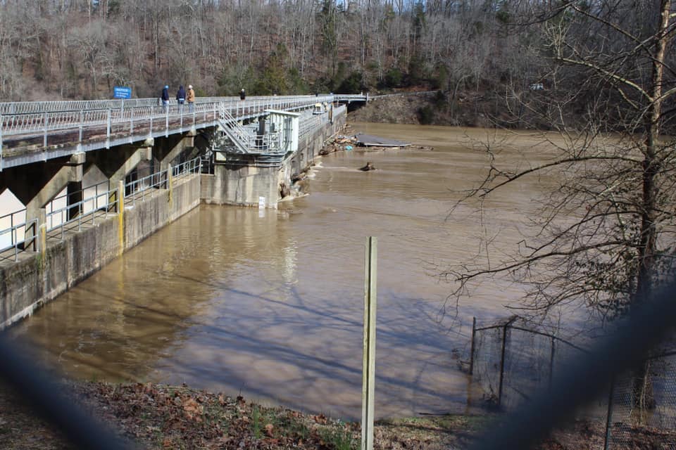
| 1 |
This is down by the powerhouse.
 |
| 2 |
 |
| 1 |
Here is a normal flow down by the powerhouse.
 |
| Satellite |
No comments:
Post a Comment