2011: (John Weeks III; Satellite)
It is now a fishing pier and the termination of a trail.
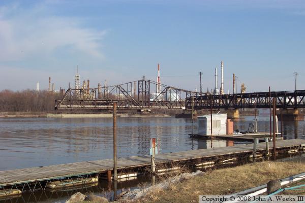 |
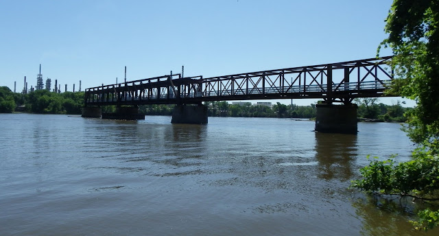
| John A. Weeks III-1894 "The Rock Island Swing Bridge is unique in that it was the last operating toll bridge in the Twin Cities metro area, and it was the last operating swing bridge for automobile traffic. Highway traffic used the bottom deck, while trains used the upper deck. That is a relatively unusual configuration given that trains normally use the lower deck of a shared bridge." [John has an extensive writeup including some history of the railroad.] |
 |
| Jack Robertson posted Rock Island Swing Bridge. The Rock Island Swing Bridge was a swing bridge that spanned the Mississippi River between Inver Grove Heights, Minnesota, and St. Paul Park, Minnesota. It was also known as the Newport Rail Bridge, as it had a spur to Newport, Minnesota, and J.A.R. bridge, after previous owners Joan and Al Roman of Chicago. It was one of the few double-decker bridges on the Mississippi, with the top level formerly used for railroad traffic and the bottom level formerly used as a road crossing. It also was one of a few toll bridges in Minnesota, and one of the last remaining ones. It closed to rail traffic in 1980, and road traffic in 1999, when the toll was 75 cents. After closing, the bridge sat dormant in the open position for 10 years before being partially demolished in 2009. It was converted into a recreational pier, which opened to the public on June 11, 2011. Crosses Mississippi River Located Inver Grove Heights, Minnesota, St. Paul Park, Minnesota Maintained by Washington County, Minnesota, Dakota County, Minnesota |
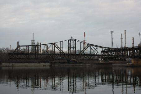
Obviously, only the far two spans are preserved spans. According to comments on BridgeHunter, a span collapsed due to a buckled beam. That would explain why some of the spans were replaced.
 |
| Photo by Jason Smith, cropped, via BridgeHunter [Jason posted a lot of detail photos on BridgeHunter, some of which show pin connections.] |
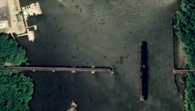 |
| Google Earth, Sep 2008 This is the last image that shows it intact. The western span collapsed just two months after this image was taken. |
 |
| Ryan Rampersad, Aug 2021 |
I was surprised how heavy the upper deck supports were until I read that the railroad used the upper deck.
 |
| John A. Weeks III-2011 |
 |
| John A. Weeks III-2011 In addition to Jason's photos on BridgeHunter, John also documents that the old trusses were pin connected. John describes several more details on his page. |
I'm glad the preservation included some of the "guts" of the old swing bridge. This would be the "final drive." The gear in the foreground was the pinion gear that engaged a rack on the swing truss.
 |
| KJ Golstein, Mar 2019 |
I wonder if you have to pay someone to use it as an "event space."
 |
| Usman Suriono, Jun 2019 |
They have installed quite a bit of interpretive material along the trail leading to the pier.
 |
| Ashley Ondrachek, Apr 2021 |
David Webster posted two photos.
Angel Binner: Rock island swing bridge
 |
| 1 |
 |
| 2 |
 |
| Dennis DeBruler commented on David's post [Included the 3D Satellite link that is at the top of these notes.] |
 |
| Dennis DeBruler commented on David's post 1951 Inver Grove and 1950 St Paul Park Quads @ 24,000 |
John Weeks posted five images with the comment:
If I had to pick a single favorite bridge, I would be unable to narrow it down to just one, but if I tried, the Rock Island Swing Bridge would be near the top of that list. It was an engineering marvel when it was built in the 1890's, and its reconstruction in 2010 and 2011 ensures that people will be able to enjoy it for decades to come.This was my longest bike ride of the season, so far. You would think that wanting to sign up for a 70.3 triathlon would be enough to get me out on the bike, but alas, no, it was a Garmin badge that did it. Rode along the Mississippi River Trail from Inver Grove to Saint Paul. A contractor conveniently closed the trail while I was in Saint Paul, so I had to detour a bit on the way back to Inver Grove to get around the impromptu construction project.
Brenda Buckman Johnson: Where would I find info on the MN bike trails? I've tried googling them but only find the ones around lakes (Three Rivers). Thanks
John Weeks: Brenda, one good way is to open Google Maps and enable the bike path layer. Dedicated bike paths show up in dark green. A second way is to google for the MN state bicycle map. It can be downloaded as a PDF or an app. Third is to google for county and city level maps. Dakota County has a bike path map. The last way is to google for specific trails like the Massabi Trail, Cannon Valley Trail, Root River Trail, or Sakatah Singing Hills Trail (as examples to get started). MN had over 4,000 miles of bike paths, making it a leader in the world in that area.
 |
| 1 |
 |
| 2 |
 |
| 3 |
 |
| 4 |
 |
| 5 |
John Weeks posted four photos with the comment: "Driving around aimlessly after pickleball class this afternoon, and i found myself at Swing Bridge Park in Inver Grover. I guess that if i am going to be stuck in Minnesota during a winter, might as well be 40 degrees and sunny. The ice is already mostly gone from the river and very little snow is still hanging on."
 |
| 1 The two original bridge spans that are part of the Rock Island Swing Bridge pier. This was once the car deck, with the trains running on the upper deck. |
 |
| 2 Looking downstream on the Mississippi River where the ice is mostly gone after being frozen over during the deep freeze two weeks ago. |
 |
| 3 Marina located on the upstream side of the bridge. People live in the houseboats year around. |
 |
| 4 Lots of patina on the old bridge steel. The railroad timbers that used to be up there were treated with petroleum products to prevent rot. Those chemicals dripped onto the steel over the decades. The bridge then caught fire and burned while it was being rebuilt 20 years ago. That left some interesting scorch marks amongst the old paint and light rust. |
 |
| 6:14 video @ 2:50 |
No comments:
Post a Comment