 |
| Sheila Kirby posted Rush Hour C1909 Dearborn and Randolph By Chicagohistory.com |
It is another data point concerning the transition from horses to cars. I don't see a single car in this 1909 photo. But there is a big truck?
This photo reminds me of the trip I took to Chicago with my daughter driving so that I could take pictures. We were headed east on North Ave. and when we were still west of Ashland we came to a stop and there were cars as far as we could see. More significantly, when all of the lights turned green, the cars did not move much. (Except for an Uber car illegally using a right turn lane to get pass us and then try to jam his way back into the through lane in the middle of a jammed intersection.) When we finally got to Ashland, we turned on it and took it to Milwaukee Ave. Then we went back north on Elston, which was neat because I was able to see the Morton Salt facility close up. We then turned right on North so that I could try to get some pictures of the Z-2 bridge. Then we went south at Kingsbury to get off of North again. They keep creating more condos in the area, but they are not building improved roads to accommodate more people living in the area. My trick of driving on the weekends when there is less traffic and more parking works fine in industrial areas. But not in Yuppieville.
 |
| Richard Pitchford posted
Busy morning on the Rush St. Bridge, 1910, Chicago.
The Rush St. Bridge was dismantled shortly after completion of the Michigan Ave Bridge in the 1920s.
Ryerson and Burnham Archives, Art Institute of Chicago.
[Just a year after the picture above and over half of the vehicles are cars. The horse/car ratio leads credence to the intersection photo being staged. It looks like cars generally used the left lane and horses used the right lane. |
 |
| Richard Pitchford posted
Madison and Clark, 1871 (prefire), Chicago.
via Ryerson and Burnham Archives, Art Institute of Chicago
|
 |
| History Season posted Traffic Jam on Michigan Avenue in Chicago, USA. 1927. US City Views posted Michigan Avenue Traffic Chicago (1927) In 1927, Michigan Avenue was a bustling thoroughfare, with traffic reflecting the rapid growth and modernization of Chicago. Known as the "Magnificent Mile," this stretch of Michigan Avenue was lined with impressive buildings, including the Tribune Tower and the Wrigley Building, which had recently been completed. The avenue was a vital link between the city’s downtown core and the increasingly affluent North Side neighborhoods. The traffic in 1927 included a mix of automobiles, streetcars, and horse-drawn carriages, all navigating the busy streets as Chicagoans went about their daily lives. This scene captures the dynamic energy of the city as it entered the Roaring Twenties, a decade of economic prosperity and cultural change. |
| of economic prosperity and cultural change. |
 |
| Richard Pitchford posted State Street, 1890, Chicago.George Miller State Street, looking north from Madison. Can see Mandel Brothers on the right. Farther down is the Marshall Field building at Randolph Street. |
 |
| Sheila Kirby shared Chicago History's photo Looking north on State Street from Madison, 1898, Chicago. |
 |
| David M Laz posted South Grant Park, 1902, with the IC Station |
 |
| Jeff Davies posted
State and Madison. Chicago. 1907. Detroit Publishing Company.
[Looking East down Madison. Louis Sullivan entrance for Carson Prairie Scott. Building now owned by Target, but the last time I was down there, they hadn't totally destroyed the elegance of the entrance.]
|
 |
Richard Pitchford posted
Jackson and Financial Place (then called Sherman St.), 1910, Chicago.
Chet Lunsford The dome of the Hobb's federal building can be seen faintly.
|
 |
| Jeff Davies posted
Monroe Street. Chicago. 1912.
Photo courtesy of Bruce Kelleher.
|
 |
| Bill Molony posted A southbound Chicago & Joliet Electric Railway interurban car passing through downtown Lockport - circa 1915. [Lockport is not "the big city," but I'll bet State Street is not this empty today. No cars and it looks like the main street of the town has yet to be paved.] |
 |
| Jeff Nichols posted View down State Street from Madison. Undated. Pitt. [The consensus of the comments is that this is before WWI.] |
 |
| Jeff Davies posted
South Water Street Market. Chicago. 1926.
Photo courtesy of Bruce Kelleher.
[What appears to be a traffic jam is instead the streets lined with horse & wagons of farmers trying to sell their produce.] |
 |
| Jeff Davies posted
Aerial View. Wrigley Field. Chicago. Year Unknown.
Photo courtesy of Dan Crosser.
[The comments determined the date as 1927-37. I can't believe how empty the streets are. According to the shadow on the field, it its early afternoon.] |
 |
| Richard Pitchford posted Milwaukee and North Avenues, 1922, Chicago. |
 |
| Sheila Kirby posted [The block in front of the Water Tower has just one car stopped at the light!] |
 |
| Richard Pitchford posted Chicago State street [According to the comments, this was taken by Stanley Kubrick for Look magazine in 1949. Maybe there is some bumper-to-bumper traffic because a movie let out.] |
 |
| Jeff Nichols posted Looking north on State Street from Van Buren. Undated. Chicago - Photographic Images of Change, University of Illinois at Chicago |
 |
| Jeff Davies posted
Cottage Grove Avenue. Looking North near 64th Street.
Chicago. 1956. Pinterest.
[Parking is a problem, but traffic still has plenty of room on the street.]
|
 |
| Jeff Davies posted
This is a photo of the intersection of Wentworth Avenue and 59th Street, Chicago Illinois. My notes date this as August 1957 and looking north-bound. That is a south bound bus (#22) on the left. So..this would mean all the buildings in this photo would be torn down to make way for construction of The Dan Ryan Expressway.
Year Unknown.
Photo courtesy of Gregory Moore.
Stan Nettis It is a streetcar not a bus.Tim Musselman Yes, a "Green Hornet" P.C.C. streetcar. |
 |
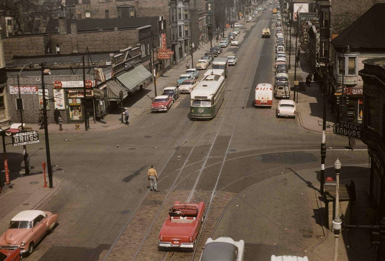
| Sheila Kirby posted Stan Nettis The picture is from the late 50s. All the cars are from the 50s. |
 |
| Sheila Kirby shared David M Laz That is Union Park. Washington St. zigzags through it and this is about 1960, given that the car is a 59 Buick. In the background is historic First Baptist Congregational Church. at 60 N. Ashland. Nice find! |
 |
| Pete Kastanes shared Skokie Blvd and Gross Point Rd in Skokie in 1964. Notice the stores in the photo that are no longer in business. |
 |
| Glen Miller posted Chicago, 1975 by Gregory Wass[By the 70s, the traffic was bumper-to-bumper as I remember Chicago traffic. Thank goodness for the comments. They identify this view as looking south along Lake Shore Drive before the S-Curve was removed.] |
 |
| Mohammad Abdelqader posted Cicero Ave, midway airport. 1940's [It is hard to believe that Cicero used to be more congested than it is today.] |
The "CTA 230 at Chicago and Wells" photo in TrolleyDodger that I saw on Facebook caught my eye as to how "empty" the street was. I'm sure that both Wells and Chicago would be jammed now. This is the first I have seen this site. Looking at some of the other photos is a reminder that people used public transit rather than cram the streets with cars.
While I was walking around Union Station taking pictures, I noticed the traffic lights were green, but all of the brake lights were still on. It made me glad I took the commuter train to town. So they already have gridlock but the City Council is allowing developers to build more high-rise condos, especially in Fulton Market. Amtrak itself wants to build on and around Union Station.
 |
| 20161021 6602 |
No comments:
Post a Comment