 |
| Ken Durkel commented on his posting Jim Potyraj Hmmmm.... I sort of remember it having green roller shades usually drawn. But that was way back when we had to make the saw move at Pine era. [CJ Tower] |
 |
| Satellite plus Paint |
 |
| Ken Durkel posted |
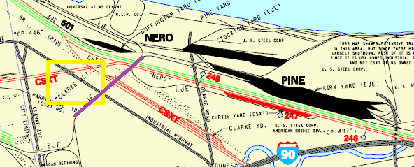
In the summer of 1986, a southbound out of Kirk Yard is seen from on the ground at Clarke Jct. The head end has crossed over the old NYC, B&O, and Wabash, and is about to cross over the old PRR. This section of the old "J" was retired when the new airport bypass was built.In the following map I added a purple line to indicate the EJ&E line the train is on and a yellow rectangle around "CLARKE JCT." because it took me a while to find this junction. The old NYC is the green NS, the old B&O is the "higher" red CSX, the old Wabash is the dotted line, and the old PRR is the "lower" red CSX. The bend in the "higher" CSX route where it leaves the NYC corridor to head west is where the CSX/B&O changes to B&OCT. I understand that B&OCT still exists because there were paperwork errors when C&O and B&O merged to form the Chessie System.
 |
| Excerpt from B&OCT Map plus Paint |
 |
| Satellite |
Update:
 |
| Ken Durkel posted Westbound on the B&OCT at Clarke Jct. Gary, Indiana. Summer, 1986. Crossing the old Pennsylvania Railroad Ft. Wayne mains. Thomas M Dupee It's just east of what we on the B&O called Industrial Avenue. Google maps currently shows it as "Airport Road". Until a few years ago, it was a grade level crossing. Now the highway is on an overpass. |
 |
| Ken Durkel posted A lone SD50 takes a westbound on the B&OCT across the old Pennsylvania Railroad crossing at Clarke Jct. in Gary, Indiana in 1986. The train is in the sun, I am standing in the shadow of CJ Tower. |
A scene impossible to reproduce at this location today, as all tracks seen here are permanently removed. Eastbound Amtrak 40, The Broadway Ltd. has passed Clarke Jct. Tower in Gary, Indiana a few seconds earlier, and is ducking underneath the EJ&E line to Kirk Yard. This section of the ex Pennsylvania Railroad west of Clark Road is permanently removed. The EJ&E ROW and overhead bridge, now CN, was likewise removed when the airport bypass was put in. Ironically, the new CN bypass passes directly through the old site of CJ Tower on an elevated fill just west of here.To gain some elevation, I am standing on the old EJ&E/PRR connection the "J" used to get to the Pennsy's yard at East Clarke.On the rear of #40, Conrail Business Car 1 has the markers on this day, November 29, 1986.
 |
| 2 |
 |
| 1 |
 |
| Ken Durkel posted Shot from Clarke Jct. Tower in Gary, Indiana in late summer or early fall of 1986, eastbound Amtrak 40 is just coming off the old NYC and through the connection between the ex PRR and the NYC. The connection was put in when the PRR ROW was retired between CJ and Whiting. The long train, and the dome car identify this as having been taken prior to October, 1986, when the Capital Ltd. and Broadway Ltd. were still run combined west of Pittsburgh. Beginning in October, 1986, they ran separately the entire way. The train is hitting the B&OCT diamonds. The signal on the left was the new signal put in place for the single tracking of the old PRR and the closing of CJ Tower. The tower closed in December, 1986. |
 |
| Ken Durkel posted Another one shot from Clarke Jct. Tower in Gary, Indiana. One of the daily CP Rail run through trains, this one westbound, bangs across the old PRR Ft. Wayne diamonds on the B&OCT in the summer of 1986. These CP run through trains do not take this routing any longer. The original PRR ROW continued straight here and into the distance. The newer connection to the old NYC curving to the right is seen here. Terry Falduto Thanks for the nice shot and narrative, Ken Durkel. If I understand you correctly: when I enlarge the photo I see a faint gravel path that leads away from the curve, generally toward the upper left. That's the old PRR ROW? That's the NYC barely visible going from L-R near the bottom of the power lines tower? Ken Durkel The old PRR ROW continued straight across the diamonds, there seems to be a gravel path in the general area in this photo. The old NYC is not far around the bend at all, and the NYC was clearly visible from Clarke Jct. But the track you in not the old NYC. That track was a connection used by the Chessie to get from the B&OCT to the old NYC and to Buffington Harbor. I have pictures from there I can post also. |
 |
| Ken Durkel posted How things have changed in 35 years. In June,1986, the end of an eastbound CP Rail train passes through Gary, Indiana on the B&OCT at Clarke Jct. In 1986 there were still a fair number of cabooses seen but they were disappearing fast. We are looking east down the former double track PRR Ft. Wayne Line, which had been severely downgraded by Conrail and was being single-tracked. Behind the caboose to the right is CJ Tower, another rapidly disappearing part of railroading, CJ was in its last few months of operation at the time of this photo, and would close in December, 1986. To stand in this spot today, one would see the B&OCT tracks, and behind that, a high fill with the CN airport bypass to Kirk Yard occupying the ground where the tower is. And little to no trace of the old PRR exists here today. Ken Durkel posted The caboose on an eastbound CP Rail run-through bangs across Conrail's ex PRR Ft. Wayne Line on B&OCT rails at Clarke Jct. in Gary, Indiana in June, 1986. Looking east on the old PRR, CJ Tower is seen beyond the caboose. This train will diverge onto Conrail's Chicago Line (NYC) a couple of miles ahead at Curtis, then at Porter, Indiana they will get on Chessie's Grand Rapids Sub. The CP trains no longer run this exact routing. The B&OCT (CSX) rails are still in, but all traces of the PRR here are just a memory. This is my photo. Mark Egebrecht: The PRR tracks ends as a stub behind the photographer. Tim Shanahan shared |
 |
| Comments on first post |
Darren Reynolds posted three images with the comment:
Conrails (EX-PRR)"Clarke Jct" (CJ) towerGary, Indiana
Tim Shanahan shared
 |
| 1 "Clarke Jct" tower in Gary, Indiana you can see the pipeline in This picture..Must have been hellbin the winter time.. June 18,1978 Photo by: C.H.Geletzke Jr |
 |
| 2 The model board at "Clarke Jct" tower Photo by: Sam Beck |
 |
| 3 A PRR track and interlocking diagram and interlocking machines information for "Clarke Jct" tower in Gary, Indiana... |
#1 is looking west and #2 is looking east toward EJ&E overhead bridge.
ReplyDeleteThanks for the correction. The captions have been fixed.
Delete