(
CRJ;
Flickr;
3D Satellite)
NorthAmericanInterlockings, old:
photo photo photo photo
Chicago and Northern Indiana Railroad Interlocking Towers (click the marker for the correct information)
A total rewrite in 2019. This is one of two towers in the Chicagoland area that is still staffed by UP. The other is
Lake Street Tower. CY Tower and Clybourn Station have seen a lot of history. Let's start with today's view of the tower.
According to
Chicago and Northern Indiana Railroad Interlocking Towers, the tower controls the "junction of UP Kenosha and Harvard subdivisions (North and Northwest Lines) and crossing with Soo Kingsbury line; also controls
Mayfair interlocking on UP Northwest line and CTC on UP between Clybourn and Winnetka." I
posted this comment with the question: "
I know that the Soo line no longer crosses the UP tracks. Does the tower still control Mayfair and the CTC?"
Ean Kahn-Treras I think control of Deval was shifted here as well after the fire.
Eric Larson Yes it does, Mondays thru Fridays on 1st and 2nd tricks. Weekends and 3rd tricks are remoted to Omaha.
The "station" is some stairs going up to some concrete platforms. And you had better understand where you are going and choose the correct stairs. Since these are historically C&NW lines, I assume they are left-hand running. So If you are going inbound on the green (UP-N) line, you use the very visible
stairs from Ashland Avenue. If you are going outbound on the UP-N line or inbound on the yellow (UP-NW) line, you use the middle platform which has stairs from both
Armitage and
Ashland (if you know to look between the overpasses. If you are going inbound on the UP-NW line, you use the stairs hidden on the side of the Ashland overpass. (See street view on the right)
Google comments confirm that there is no wheelchair access and the shelters are minimal.
After seeing how bare-bones this station is, I now understand why the city is talking about building a rapid transit line using the tracks that are now in Goose Island rather than pay to build a decent station here with restrooms and wheelchair access.
In contrast, it used to have a building and roofs along the edge of the platforms.
 |
David Daruszka commented on a post
Banjo signal semaphore combination on the C&NW.
[David posted this photo to illustrate another example of a Banjo Signal. (The initial example was at the IC bridge over the Ohio.)] |
Heinz had a pickle factory south of Tower A-2. But obviously the pickles factory on the right side of the above photo was a different factory.
That building still exists on the south side of Cortland Street, but the windows have been redone.
To clarify the above location, David provided another photo.
 |
David Daruszka commented on a post
Dennis the photo was taken at Clybourn Jct., that's the Clybourn Station in the background.
[This photo provides a portal view of the Deering Bridge. Catching UP-NW inbound and UP-N outbound would be pleasant. Catching the other two directions is bare platforms, and it is not clear how you would get to the UP-NW outbound (left-most platform).] |
A couple more views of the station.
 |
Dave Arganbright shared Chicago & North Western Historical Society's photo.
I stumbled across the CNWHS facebook page, and realized that they have published a killer collection of old B&W facility shots and the like. Clybourn!!
The shared comments: Here is another view of the C&NW station at Clybourn in Chicago which we published on March 13. The tracks to Crystal Lake and Janesville are on the left while the ones on the right go to Waukegan and Milwaukee. We are adding this one because we see pickle cars spotted by a pickle company at the right side of the photo. That building still stands. |
 |
|
Clybourn was an important junction point that warranted an impressive station. Archibald Clybourn built Chicago's first stockyards near here. The tanning industries that grew up around it were a remnant of that early era. |
 |
Chicago & North Western Historical Society posted
Look what is hauling this C&NW commuter "scoot!" That was not an unusual act for the circa 1959 period. This train is outbound from downtown Chicago pulling into it's first stop at the relatively new Clybourn depot site. The train is on an outbound run on what is today called the "north line." It was called the "Milwaukee Line' in those days. The shelter still stands. |
 |
David Daruszka commented on the above post
Clybourn in past times. |
Bob Hendricks
posted two photos with the comment: "Antique Typogravure * Clybourne Station Chicago & Northwestern Railway Company. 2001 Ashland No date. Via ebay.com"
 |
| 1 |
 |
| 2 |
I'm doing a total rewrite because a) I have found some more historical photos and b) I had errors concerning the names of the junction and station. To be fair, I was confused because different sources used different names. I will use "Clybourn" for the station and "CY Tower" for the junction.
To understand the location of the junction, what is now the
606 Trail was the "Bloomingdale Line" that extended east from
Tower A-5, crossed the C&NW at this junction, crossed
Bridge Z-6 and connected with Milwaukee's
Chicago & Evanston branch. By the year 2000, it was the Canadian Pacific crossing the Union Pacific. According to Google Earth, the crossing was removed in 2000 and the Milwaukee remnant operated by the
Chicago Terminal Railroad connected with UP's North Avenue Yard. (As of 2018, CTR abandoned operations of the Milwaukee remnant. The city is working on getting that track.)
 |
| Google Earth 4/23/2000 |
Note the fresh white ballast where some of the diamonds were replaced with regular rail at the former CP crossing.
 |
| Google Earth 10/10/2000 |
We can divide the history of this junction in to four "eras:"
- Before elevation (1874-1913)
- After elevation (1915) but before the I-90+94 expressway was built (1960s)
- 1960s-2000
- 2000-now
I don't have any "before elevation" photos, so I'm ignoring that era other to note that the charter was granted in 1872 and that the line was built
in Bloomingdale Road (later Avenue). As you can imagine, the residents did not like having a railroad in their street. The city passed the ordinance requiring its elevation between Lawndale and Ashland in 1910, which was completed by the required deadline of 1915. [
ForgottenChicago]
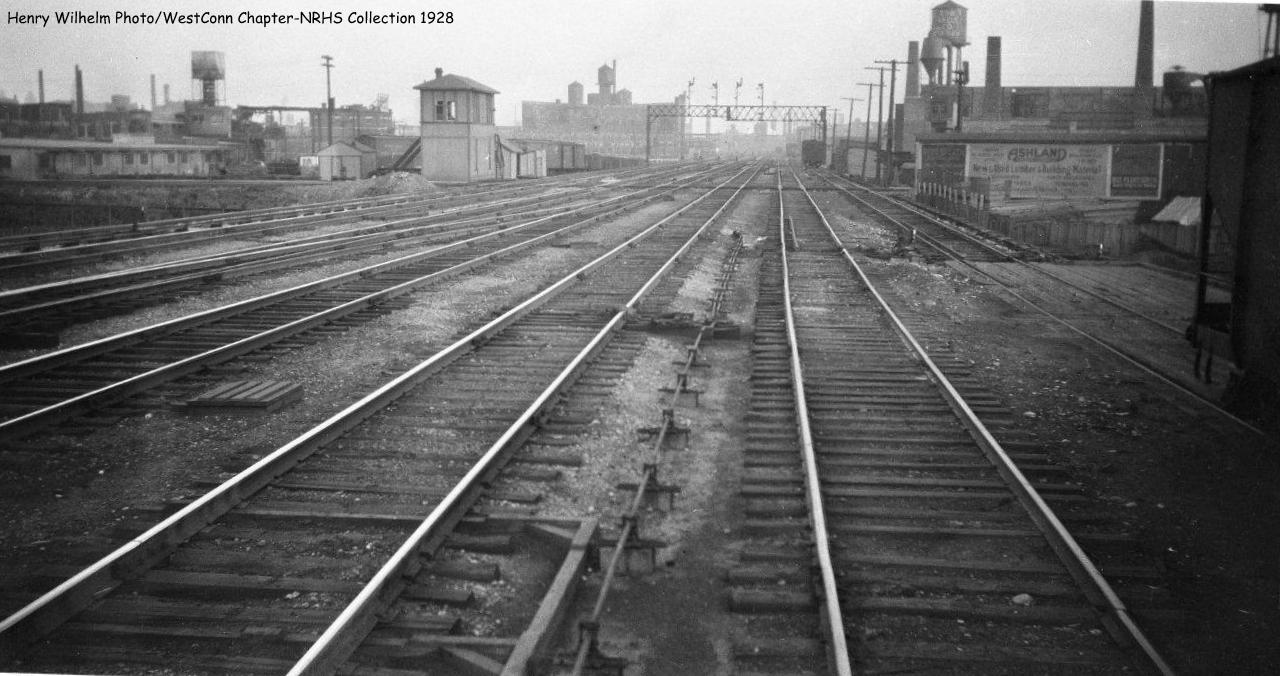
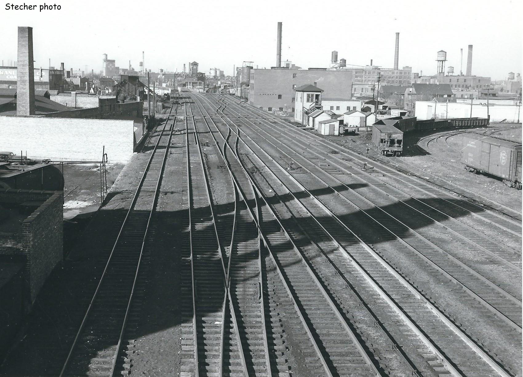
After elevation, we have the following photo looking outbound across the junction. I marked the tower with a red rectangle, the Clybourn Station with a yellow rectangle, and the Milwaukee tracks with a blue line. We can see that this tower was in the southeast quadrant of the junction.
A photo looking inbound across the junction.
This tower was wood. In the center background we see
the huge gasometer that was north of Goose Island.
I still haven't figured out why the Milwaukee track seems to cast a shadow on the C&NW tracks in this 1938 aerial photo. At first, I thought the Milwaukee was elevated over the C&NW, but the above photos show that was clearly not the case.
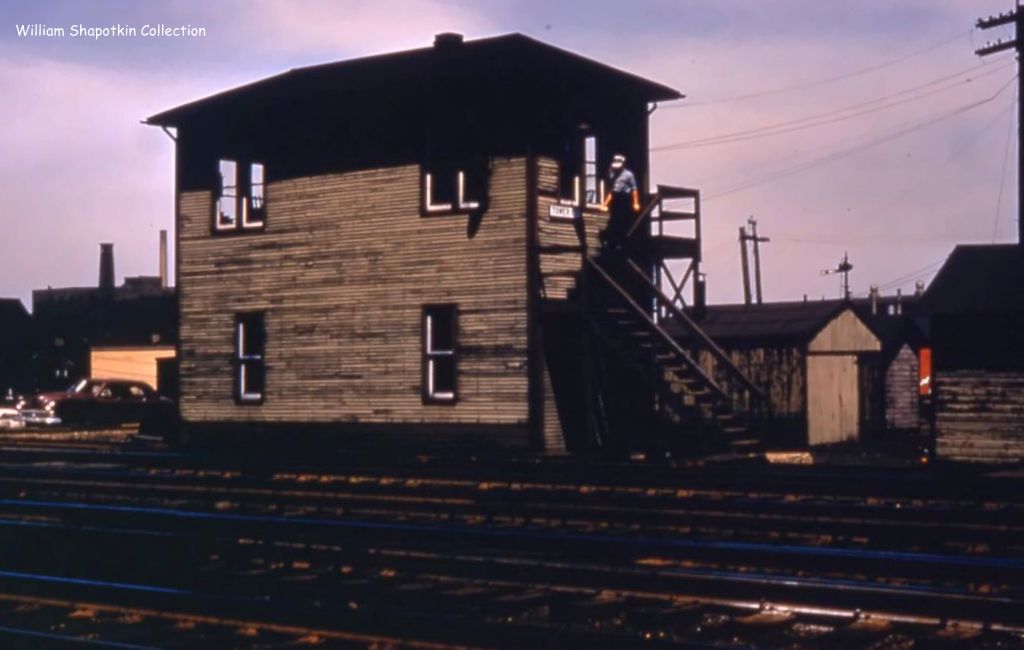
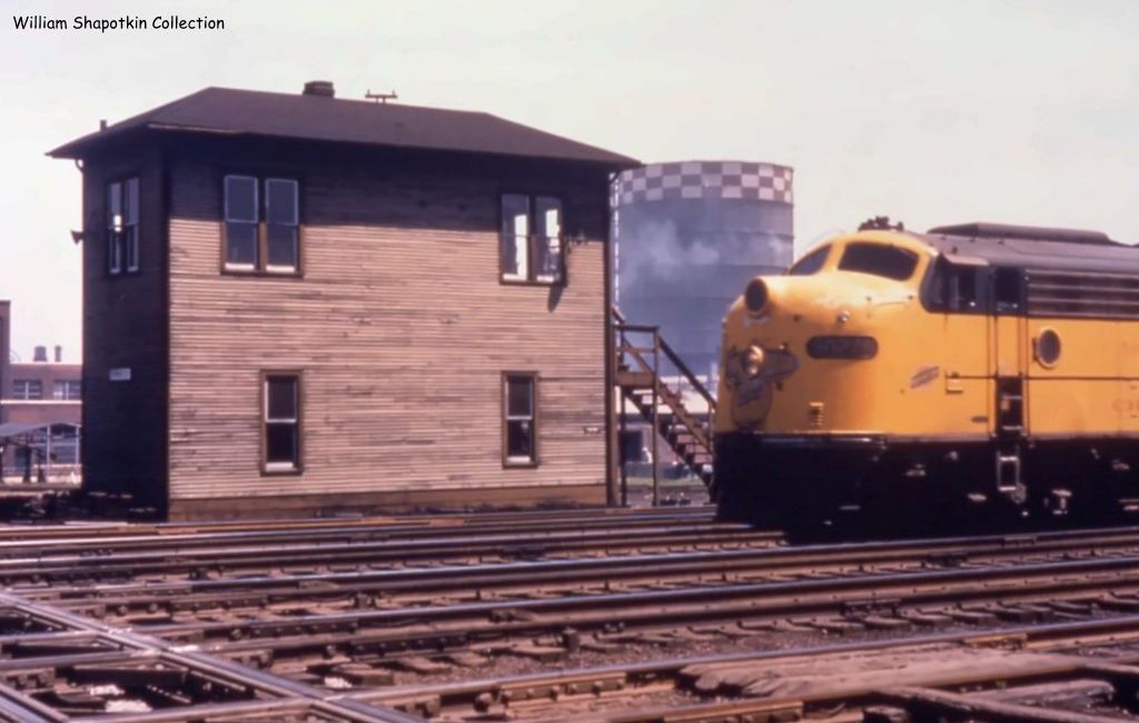
When the expressway was built, the wooden tower was replaced by the brick tower in the northwest quadrant of the junction that is shown at the top of these notes. Since the crossing was removed in 2000, Mark's 2011 track diagram shows the Milwaukee remnant,
CTR, connecting with UP's North Avenue Yard.
 |
Douglas Kydd posted
C&NW at Clybourne [CY Tower] in 1974.
Douglas Kydd It wasn't ALWAYS Metra.
Jerry Jackson The reefers in the back are a nice touch too. [It looks like they are on the curved connector to the Chicago & Evanston Branch.]
Kevan Davis About to hit the diamonds at CY.
[Note the shadow of the tower in the foreground.] |
 |
Lou Gerard captured the Bloomington Line still in use in June, 1995
[Sorry, I forgot to note the source of this photo. Note the tower on the right.]
|
 |
Ned Carlson posted
CNW steam pulling bilevel cars in Chicago. Photo is from James Yanke
Looking south from Clybourn. You can see the gasometer in the background that was a landmark next to the tracks for ages.
That's the signal bridge for the northwest line at Cortland and you can see the one for the diamonds at CY in the distance. |
 |
Chuck Zeiler 1978
[Quite a few passengers leaving an outbound. CNW left-hand running still confuses me.] |
 |
Chuck Zeiler 1979
The following is excerpted from an article by Phillip A. Weibler entitled 'Set 'Em Up' in the Summer 2010 issue of First And Fastest, the publication of the Shore Line Interurban Historical Society.
Commuter jobs benefit from repetition - same locomotive, same number of cars, same schedule every day. Student Engineers (aka Pups on the C&NW) would watch in awe as the 'old head' brought the train to a quick, smooth stop station after station. How'd he do that? What was the secret? The Set 'Em Up! Since the number of cars and train speed would be the same every day, a regular Engineer would develop a series of Set 'Em Ups - marks along the right-of-way that could be spotted easily: a milepost, the end of a fence line, the back door of a house - anything could work, and he probably had an alternate set of marks on the other side of the tracks in case a passing freight blocked his view. At the Set 'Em Up the Engineer would set the big brake - the automatic air brake on the train - to full service and shut the throttle to Idle. A good Set 'Em Up would actually stop the train a little short of the station platform, so the Engineer could release a little brake and adjust the final stop to use the whole platform. The air brake on passenger trains is set for Graduated Release, so it can be set, partially released, and then reset - as long as there is air in the car reservoirs. Some Engineers have been caught by making too many adjustments so that there is finally no response from the brake, known as 'pissin' away the air'. Along with the Set 'Em Ups, Engineers worked with Spots - the precise location for a station stop that, for example, would allow crossing gates behind the train to clear up or that would keep car doors away from a depressed crosswalk. |
 |
Chuck Zeiler 1979
[This is at Tower A-2 but I include it because it has more of the "Set Em UP" info.]
Not a very good photo but it helps illustrate the following by Phillip A. Weibler entitled 'Set 'Em Up', excerpted from First And Fastest, the publication of the Shore Line Interurban Historical Society.
Controlling slack and running a smooth train called on the Engineer's skill with both the brake and the throttle. Slowing down for a speed restriction - for example westbound at Western Avenue crossing the Milwaukee Road - the Engineer would set the big brake on the train, but bail off the engine brake, then reduce the throttle to Run 1. He'd release the brake and hit the diamonds right at 30 mph, then get right after the throttle to pull the train out of the restriction smooth and fast, with no slack action. Eastbound, again the Engineer would reduce the throttle to Run 1, but never to Idle. The old F7's and E's would hang on to transition in Run 1. If the Engineer went to Idle and then opened the throttle again, the locomotive power contactors would drop out, then pick up in series, but drop out again because of speed and then pick up in parallel. While all this was going on, the train was just drifting. When the locomotive finally decided to go to work, it gave the train a pretty good boot. |
 |
Steven J. Brown posted
Metra F40PH 152 heading down the CNW Harvard Subdivision at Clybourn in Chicago, Illinois - November 23, 2001. |
 |
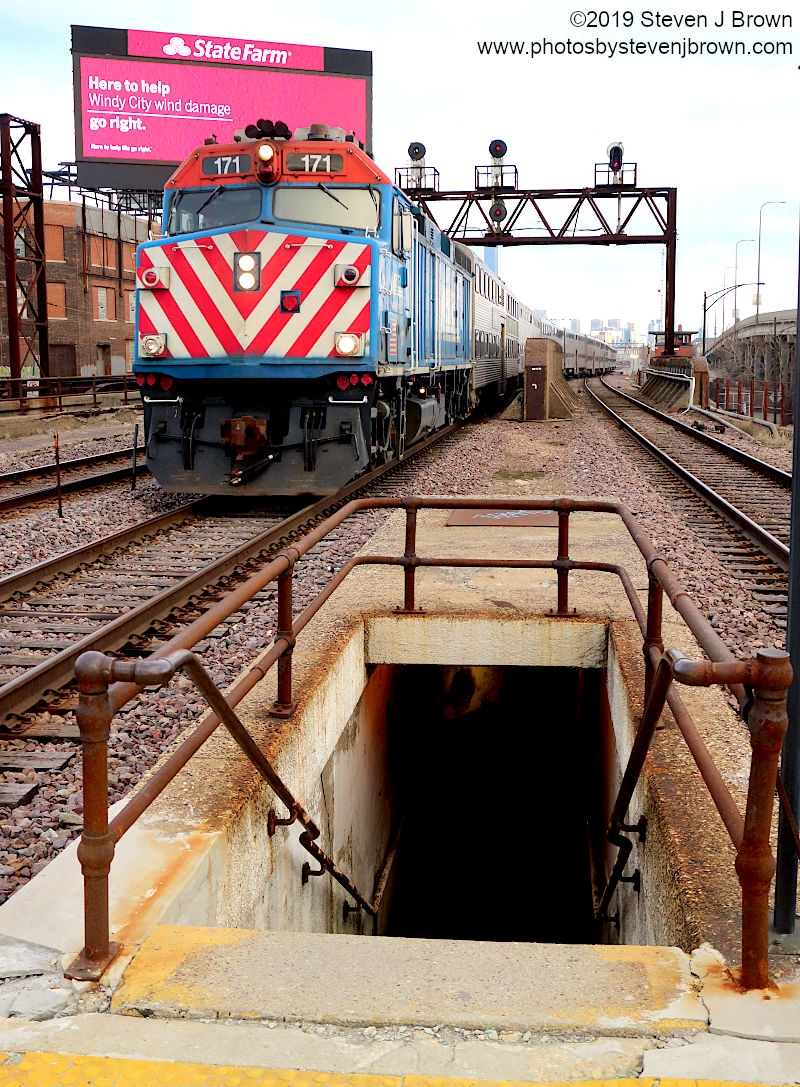
Steven J. Brown posted
Metra F40PH 171 (built 1983) heading up the CNW Harvard Sub center track at Clybourn in Chicago, Illinois - April 2, 2019. |
This photo was taken from Clybourn Station looking South. Note CY Tower to the right of the locomotive.
 |
Steven J. Brown posted
Metra F40PH 172 approaching Clybourn on the CNW Northwest Line in Chicago, Illinois - April 2, 2019. |
 |
Mark Llanuza posted
Its 1993 I'm inside CY tower in chicago with a view looking south with a northbound CNW [ Metra ] getting ready to cross the Milwaukee road.
Robert Blackmore: That’s the Milwaukee Road’s bloomingdle Line starts west at tower A5 runs along Bloomingdale Avenue ( now the Bloomingdale bicycle trail known as the 606 )  to the CY tower and points East to several customers on goose Island.  at one point this was the Milwaukee roads mainline to downtown Chicago.  I worked that line with Marvin Mills (soo)as my conductor coach. And engineer Tom , Mike and Pete (Milw)and a few others. The CP (soo) sold this line to the city of Chicago for one dollar to convert the line into a bicycle trail. Good philanthropy- green space.  the elevated structure was in disrepair. as an apprentice conductor I delivered freight to many customers one of them I remember a centerbeam F483, where I tied the centerbeam down in the middle of the street I think Kingsbury Avenue /goose Island. “Street running” And delivered several mill gondolas G113 to a scrap metal customer. Amazing experience and camaraderie with my conductor and engineers Good times for sure. Mike Howard: Robert Blackmore Also ran up north of Wrigley Field . I remember only once seeing a switch run cross Belmont ave . |
%20Chicago%20&%20North%20Western%20Railroad%20Fans%20_%20Its%201993%20I'm%20inside%20CY%20tower%20in%20chi.png) |
| Comments on Mark's post |
A
D.W. Davidson Flickr Photo of a commuter crossing the Blomingdale Line diamonds from the cab of another commuter. A south view of the tower is to the left of the commuter.
A northeast view of the tower
Around seven minutes into
this video, the trains bang the diamonds and then you can see the tower on the right. At 7:25, it stops at
Clybourn Station; then at 8:35 it resumes its trip.
Dec 2024:
 |
Mark Llanuza posted
CNW CY Chicago tower that is to be retired Today Dec 6th 2024 Friday was built by the Chicago & North Western in 1961 as part of the construction of the Northwest Expressway. This tower controlled the interlocking of the Harvard sub and the Kenosha sub as well as North Ave yard . Later in years in controlled Mayfair CNW tower as well .Today after midnight this will be operated out of Omaha .Most likely the tower men will use there seniority to move to CNW Lake street tower |
First & Fastest
posted four photos with the comment: "As of 12:01 AM on 12/7/24 Union Pacific's CY Tower on the former C&NW ceased to be a manned tower with control turned over to the UP Dispatchers in Omaha. The tower controlled the Jct. of the North and Northwest UP lines at Clybourn and Mayfair. The former Milwaukee Road Bloomingdale also used to cross the C&NW here. Another interlocking tower goes into the history books."
The Blackhawk Railway Historical Society
shared |
| 1 |
 |
| 2 |
 |
| 3 |
 |
| 4 |


%20Chicago%20&%20North%20Western%20Railroad%20Fans%20_%20Its%201993%20I'm%20inside%20CY%20tower%20in%20chi.png)


On page 89 of John Swajkart's 1976 book "Train Watchers Guide to Chicago", in the upper left corner of that page, is a picture in the upper right background of a tall domed building (now gone). I remember it when I was a child in the early '50's. Anyone know what building it was? Thanks.
ReplyDelete